
Answering the most important questions first

Category Archives: Resources and Routes
VOTD: A Day in the Life of a Fire Lookout
via West County Explorers Club: Having visited a couple of fire lookouts this year, I found them to be pretty fascinating places. In this age of electronically monitored everything, rangers and volunteers still head to the tops of mountains to scout for forest fires with nothing more than simply surveying gear.
When smoke is spotted, a bearing is taken using something called an Osborne Fire-Finder, basically a circular map and a sight on a rotating turntable. Once the fire’s bearing is recorded, it’s shared with other towers, who, if they are within visual range, also report a bearing. With a bearing from at least two towers, an approximate fix on the fire can be made. Using the line of sight across the circular map (the lookout tower is located in the center of the map) estimates of the fire’s location can be made if no other lookout is within visual range.
This video, about the Mt. Tamalpais fire lookout in Marin County, just north of San Francisco, is more about the view but I’ll hope you’ll enjoy it just the same.
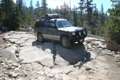
Sierra Nevada Camping Spots
I went on a nice little solo trip up to the Sierra Nevada this past summer, found some great back country camp sites, and thought I’d share them with you. Keep these in mind for next summer when the snow clears.

How to Get a Last Minute US Passport!
“Do you have a current passport?”
“Of course!” “…Are you sure?”
The (Secret) City of London
Did you ever know there was a London in London?
Watch this captivating and funny video to learn more about the City of London and its 11000 thousand habitants.

The Top 5 Trip Reports
Trip reports are to Overlanders what wine is to the French—a daily necessity.
When not traveling, there are no better ways to dream and plan your next adventure.

A Journey into Somaliland in an FJ Cruiser
I became interested in Somaliland as a traveler and as an economist. At the time, I was writing a chapter of an economics textbook and wanted to use the pirates of the Gulf of Aden as the topic of the chapter.

Dust Therapy: Stretching The Legs of My 4Runner (and Dog.)
A good friend of mine (who works too much) was back in town yesterday, so we decided that it was about time I took my truck out.

The Library: Good Books on the Outdoors
As you plan your summer trips, it’s always good to brush up on your outdoor skills.
They all make great reads.

Thoughts on Gear Selection After Riding to Ushuaia
Having the right gear can often make all the difference in the world when it comes to the enjoyment of your trip. Having the wrong gear can take away from your enjoyment of a trip, …

Overland Expo 2012 is around the corner!
Things have changed quite a bit in the Overland world since…
The 2009 edition was held at the Yavapai Fairgrounds in Prescott Valley

10 Great Tips to Ease Your Airline Travels
Here are some tricks I have learned over the years to make traveling a little bit more enjoyable.

Arctic Ocean Expedition: Planning
Winter 2007, N69 26.70 W133 01.60

Lower Looner Land
As a group, we climbed about six routes and I was able to climb three, with the most difficult being a 5.7. Here are a few pictures of our adventure.

Jerome Snow Run
We had all of the adventure we wanted …
One of the vehicles went into a 100 yard slide before even getting to the trail.

Coke Ovens, Box Canyon
…The water continued to rise in the narrow canyon as we pushed towards its exit. The confluence of every inlet and waterfall filling its width…

Chiricahua Mountains
Date: 5/1-3/2004 Trail Time: 5-6 hours Location: Coronado National Forest, SE of Wilcox Arizona. The trail starts at the intersection of Route 181 and the Pinery Canyon Road (Note: I have detailed GPS and track data available for this trip, but would like to limit its recipients to properly equipped and environmentally conscious travelers. Please…

Expedition Portal Announces 2011 Overland Rallies details
Expedition Portal, the international community of adventurers and overland travellers, has announced the details of their 2011 regional Overland Rally series.

So You Want a Lightweight Adventure Travel Bike….
As my own adventure travel preferences have evolved, I have found off-road lightweight maneuverability and performance, coupled with longevity, paramount. Enter the interesting prospect of the Husaberg 570 FE…

Sibley Mansion
Sibley Mansion and Bluebird Mine, Copper Creek Arizona