
Each year, our staff members spend months exploring some of the best backroads our planet has to offer, from the red sands of the Simpson Desert to the frozen expanses of Greenland. Along the way we’ve discovered there’s no lack of breathtaking adventures to be had, but believe it or not, some of the best are right here in the United States. That’s why we’ve spent the last five years recording some of our favorite four-wheel drive tracks and backroads in the USA to create a resource for our readers called Overland Routes. Within each, you’ll find GPX tracks with a description of the drive, resources for the area, photos, and a slew of other information you’ll want to start planning your own overland journey. Below, you’ll find a list of these fantastic trails exploring regions ranging from the sleepy borders of Texas to the Arctic wilderness of Alaska. While we won’t be bold enough to actually call them the best, they’re certainly some of the best. We hope you enjoy these places as much as we have and ask that you take the utmost care in preserving them. The best overland routes in the united states
You can view all of our GPX tracks by clicking the Overland Routes link at the bottom of this page.
Tread Lightly
In order to ensure future generations can enjoy these routes, it’s vital that we all abide by Tread Lightly’s philosophy of backcountry travel. We encourage you to get involved and take their basic courses, but at a minimum please read the link below before driving any of these trails.
PLEASE READ THESE BASIC TIPS BEFORE DRIVING ANY OVERLAND ROUTE.

The Overland Routes
El Camino Del Diablo

El Camino del Diablo translates to The Road of the Devil. The name itself evokes an eerie feeling of discomfort, and it should. Over the last 1,000 years this barren track has earned its name with soaring temperatures, waterless expanses, and an ever-rising death toll. It comes from humble beginnings as a Native American footpath, but earned its infamy with the Spanish in 1540. During his march from Mexico to the fabled cities of gold, conquistador Francisco Vázquez de Coronado dispatched a small expeditionary force to seek out a rumored river junction to the north. Although the expedition did return, the immense hardship encountered during their journey led the soldiers to name the path after the Devil himself.
Over a century later, a Jesuit priest named Eusebio Kino retraced the route, this time mapping the water sources and punching through to the Pacific. Unknowingly, Kino paved the way for over 300 years of travelers to follow, including immigrants, gold seekers, smugglers, and more recently, four-wheel drive enthusiasts.
To download this route, or read the full story, click HERE.
The Texas Hill Country

Prayer is the best way to meet the Lord, but trespassing on this property is faster. Folks in Texas are known for many things, but taking kindly to trespassers ain’t one of ’em. Don’t get me wrong, most would give you the shirt off their back if you needed it, but show up on their land uninvited and they’re likely to send ya packing faster than a prairie fire with a tailwind. Trouble is, there’s very little land in Texas that isn’t private. Between the constant creep of urban sprawl, seemingly endless ranches and farms, and of course the oil claims, it’s tough to find an inch of dirt to drive on—but there are still a few vestiges for those who know where to look. Take this route for example, one of our favorites from the heart of the Texas Hill Country.
To download this route, or read the full story, click HERE.
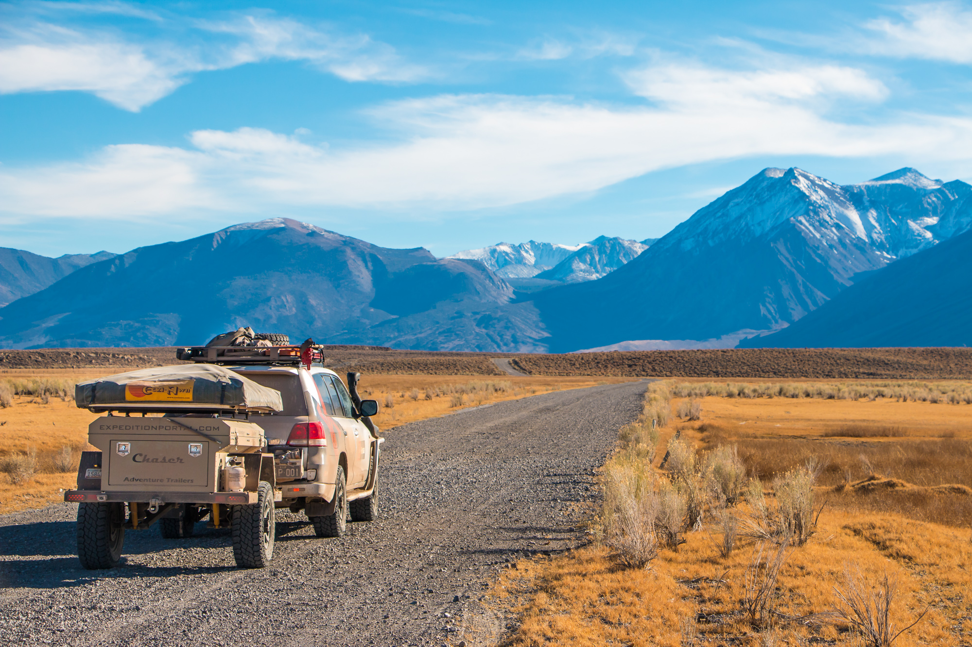
The Continental Divide: New Mexico to Southern Colorado
When most people envision New Mexico, they picture the outlines of rocky plateaus, desert sunsets, and Native American culture. It’s understandable, as you can certainly find these things in abundance throughout the state, but there is also something more: the Continental Divide. Drivers can climb to towering heights, weave through dense forests, and walk amongst ancient lava beds. There are hot springs carved from cliffsides, and clear streams just waiting to be fished or swam. In many ways, the region is a less-trafficked version of Colorado—one that is underappreciated by, or unknown to four-wheel drive enthusiasts. Last summer we set out to change this with Hema Maps by bringing the area together with some of the most famous trails along the divide.
To download this route, or read the full story, click HERE.
The Northern Arizona Traverse

Picture Arizona in your mind; imagine traveling the back roads and observing its landscapes. What do you see? For many people, it’s a sprawling desert dotted with cacti—a place of desolation where sunbaked sands cover endless miles of countryside. But this state has a secret, one that you’ll discover if you venture into the forested hills and grass-covered highlands of its northern region.
To download this route, or read the full story, click HERE.
The Pacific Crest Overland Route: Summary Story
In 2015 Overland Journal launched a series of articles in conjunction with the Australian company Hema Maps. Christened Overland Routes, the new column shared our favorite tracks from around the nation, while providing readers with the information they needed to complete them via the Explorer app. After a year of scouting, their team officially unveiled the U.S. application, and with it a plan for two epic routes. The first would follow the Continental Divide, a well-known and loved track. The second would be something entirely new, a grand tour through the nation’s Western states, one we’d come to call the Pacific Crest Overland Route. This trek would stretch from the Arctic peaks of the Brooks Range to the sunbaked sands of Southern California, visiting some of the country’s greatest treasures along the way. From national parks to hidden hot springs, apple orchards to desert dunes, it is the perfect way to experience the immense beauty and adventure of the Western United States.
To read the full story of this journey, click HERE, but to download the individual routes and guides, check out the stories below.
The Pacific Crest Overland Route: California

What do you envision when you think of California? Shimmering oceans, warm beaches, and a stunning coastline? Perhaps towering redwoods or sparse deserts filled with Joshua trees? You wouldn’t be wrong to think of any of these things, but what if I told you that this beautiful state is filled with so much more? Within its border, you’ll find cascading sand dunes stretching far into the distance, shimmering lakes with depths of over 1,000 feet, and abandoned ghost towns backed by craggy mountain peaks. It’s an adventurer’s dreamland and far more accessible than many people realize. From the northern reaches of the state near Mount Shasta to its southern border with Mexico, we have charted a course through some of the Golden State’s most scenic territories and it is almost entirely on dirt.
To download this route, or read the full story, click HERE.
The Pacific Crest Overland Route: Washington

Adventure doesn’t always look like what you would expect. It is not bound to the toughest trails or limited to foreign lands with unfamiliar cultures. Some journeys are about rediscovering the places we already know and seeing them in a new light. This was our goal with the Washington portion of the Pacific Crest Overland Route (PCOR)—to experience the unique beauty of its small towns and backroads, from the shores of Bellingham to the Oregon border. In truth, we only had time to experience a fraction of the things we had hoped for, but if you choose to explore this route for yourself, it is easy to branch out and see more of the state’s many wonders.
To download this route, or read the full story, click HERE.
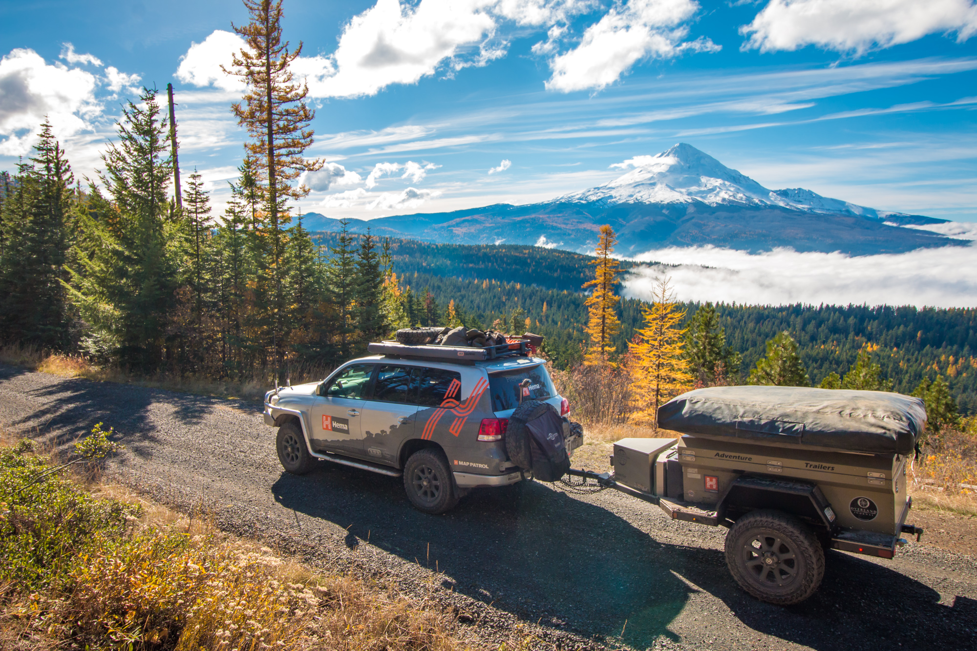
The Pacific Crest Overland Route: Oregon

A cool wind whistled through the pines around us, and I took a deep breath, filling my lungs with crisp mountain air. We had only left the hustle and bustle of Portland’s streets that morning, but the city’s traffic jams and red lights already seemed a world away. Their constant drone had been replaced by the quiet tunes of nature’s melody, and I tried to appreciate its subtleties while my eyes surveyed the vista before me. Far below, a sea of clouds stretched out toward the horizon, rolling over the forest floor and breaking against the rising terrain like waves on a distant shore. Here and there, splashes of brilliant gold trees dotted the landscape; rising from the center of it all was Mount Hood, its snow-capped peak piercing high into the blue sky above. I leaned back on the grass beside the road and sighed in admiration. This was the Pacific Northwest I had been dreaming of—this was Oregon.
To download this route, or read the full story, click HERE.
Elephant Hill and Valley of The Gods

This route, which begins in Mexican Hat along the San Juan River, is one of the most beautiful, remote, and challenging multi-day tracks in the Desert Southwest. It is critical to top off the tanks, as it is nearly 200 miles of (mostly) off-highway driving to the next fuel stop in Monticello. The dirt section begins just below the Moki Dugway (a worthwhile detour) on SR 261, where it turns east on Valley of the Gods Road. Though this section is relatively easy and only requires four-wheel drive in a few places, the views are breathtaking and there are world-class primitive campsites. Our favorite camping areas are near Castle Butte along the northernmost reach of the trail. The road continues between sandstone formations and through several dry washes before reconnecting with US 163.
To download this route, or read the full story, click HERE.
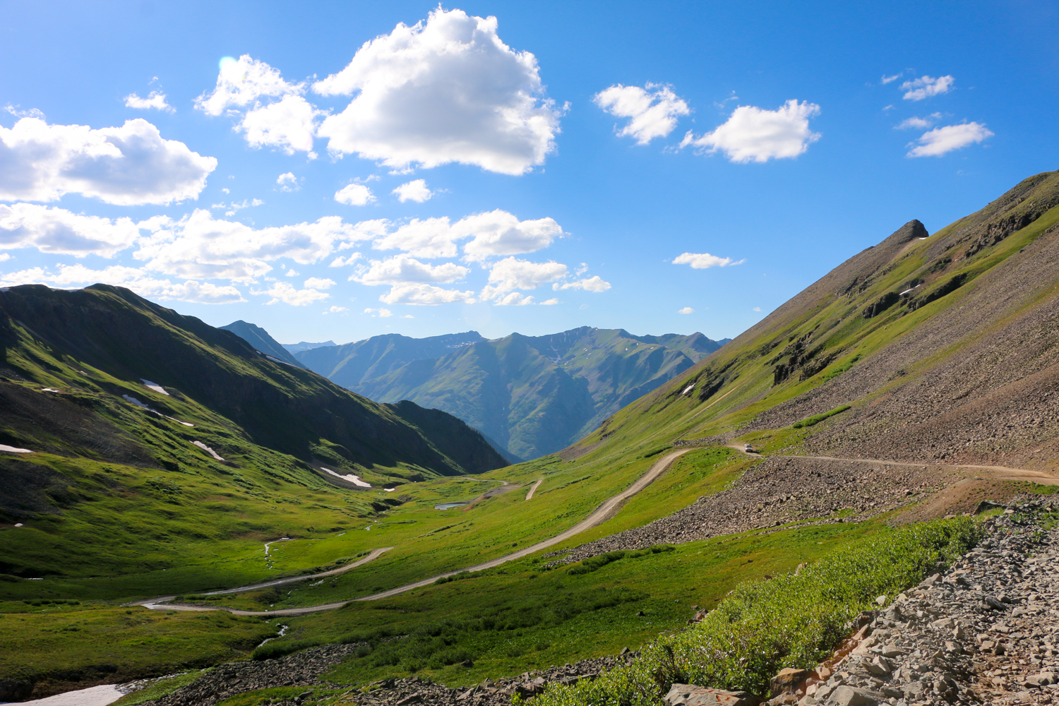
The Alpine Loop

The series of roads between the mines is now known as the Alpine Loop Back Country Byway, and is one of the most scenic and rugged ways to witness the majesty of the San Juans. Along the 70-mile loop drivers will navigate narrow shelf roads covered in loose rock, conquer passes at nearly 13,000 feet, and witness views that can rival almost any in the world. We strongly recommend a high-clearance four-wheel drive for this route, but it is possible to complete the track in a soft-roader if proper precautions are taken.
Travelers can witness a large variety of interesting and unique flora such as cushion plants and alpine forget-me-nots, which grow only in tundra environments such as the high San Juans and the Arctic. At lower elevations, pine, fir, and spruce trees dominate the landscape in an endless sea of green; cottonwood, aspen, and oak may be found among them. Shrubs include Rocky Mountain maple, sage, juniper, and many others. The wildflowers however, are the region’s crowning jewels, with over 150 different species.
To download this route, or read the full story, click HERE.
Death Valley National Park
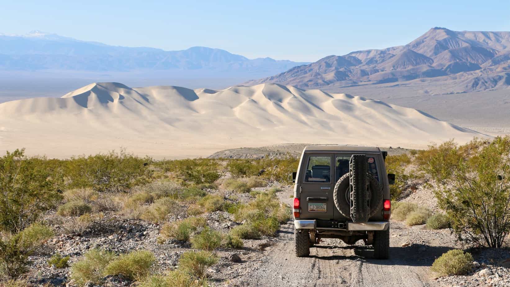
It’s easy to see the allure of national parks like Yellowstone and Yosemite, where breathtaking views and lush ecosystems are just steps from the pavement, but many struggle to appreciate the desolate nature and arid expanses of Death Valley. Here you have to look for beauty, or even work for it, with a hike up a hill or drive down rough roads. This doesn’t suit the fancy of many parkgoers, but for those who love to journey off the beaten track, the unique and strange sights of this desert make it well worth the trip.
To download this route, or read the full story, click HERE.
Anza-Borrego State Park

Anza–Borrego Desert State Park (ABDSP) is a remote moonscape that beckons the adventurer with technical terrain, expansive geology, and the solitude of desert campsites. It is named for the Spanish explorer Juan Bautista de Anza and borrego (bighorn sheep). At 600,000 acres it is the largest park in California, featuring over 500 miles of dirt roads, 110 miles of hiking trails, and 12 wilderness areas.
To download this route, or read the full story, click HERE.
Big Bend National Park

They say that everything is bigger in Texas, and standing in the heart of Big Bend National Park you’d sure believe it. It’s a land of burning sunsets, soaring mesas, and enchanting vistas that sprawl toward the horizon until meeting softly with the deep blue of the West Texas sky. A place of simplicity and wide-open spaces, traffic means a rattlesnake on the road, and international commerce is a rowboat crossing to a sleepy Mexican town. In all, the park spans more than 800,000 acres and is as rugged, romantic, and wild as any Western film.
To download this route, or read the full story, click HERE.
The Mojave Road

The Mojave Road is one of the best known and most diverse overland routes in the United States. Like most western tracks, it was established by Native Americans and used as a footpath for travel long before Europeans arrived to map it. In 1776 the first documented crossing was completed by Francisco Garcés, a missionary on Juan Bautista de Anza’s expedition to California. Over the coming centuries the road would transform into a supply route, making way for wagons, equipment, and rail lines heading to California.
Despite its similar history to other desert crossings, the Mojave Road is unique. Most classic routes were improved over the years or turned to pavement; the Mojave became lost in time when more efficient routes for railroads were discovered. Even today, very little maintenance or development has occurred, allowing drivers to not only enjoy the untouched desert, but do so on what is essentially the same road used over 150 years ago.
To download this route, or read the full story, click HERE.