
In this installment of the Expedition Portal series on brands that inspire us, Senior Editor Ashley Giordano profiles the off-road GPS and mapping app onX Offroad.
In 2009, outdoorsman Eric Siegfried lost his way while hunting at night. Navigating through rough terrain in the dark, Siegfried wished for the ability to see public and private land boundaries while in the field. That vision became onX Hunt, an app that evolved to include thousands of layers with beta informing hunters throughout America. Eventually, the company realized that its app platform and GPS capabilities could be tailored to meet the needs of other outdoor enthusiasts who require accurate navigation tools. onX Offroad was the natural next step.
While you may be familiar with onX Offroad’s main features, including the Route Builder and Turn-by-Turn navigation tools, the company also aims to preserve outdoor recreation opportunities for future generations through various grants, programs, and initiatives. I connected with Andy Zielinski, the product marketing lead at onX Offroad, to learn more about these opportunities and about the new features the team is particularly excited about for 2025.
What are onX Access Initiatives, and why are they important?
Access can mean different things to different outdoor enthusiasts. For the motorized community, that usually means trail or road access. Some projects improve access by adding more trails and roads. Some projects preserve access to existing trails and roads by maintaining or cleaning them up.
Collective stewardship of our shared places is critical. By supporting initiatives (whether grant-funded projects or community engagement and education) that help restore and take care of these places, we can preserve access to them. Because if we don’t, access can be lost forever.
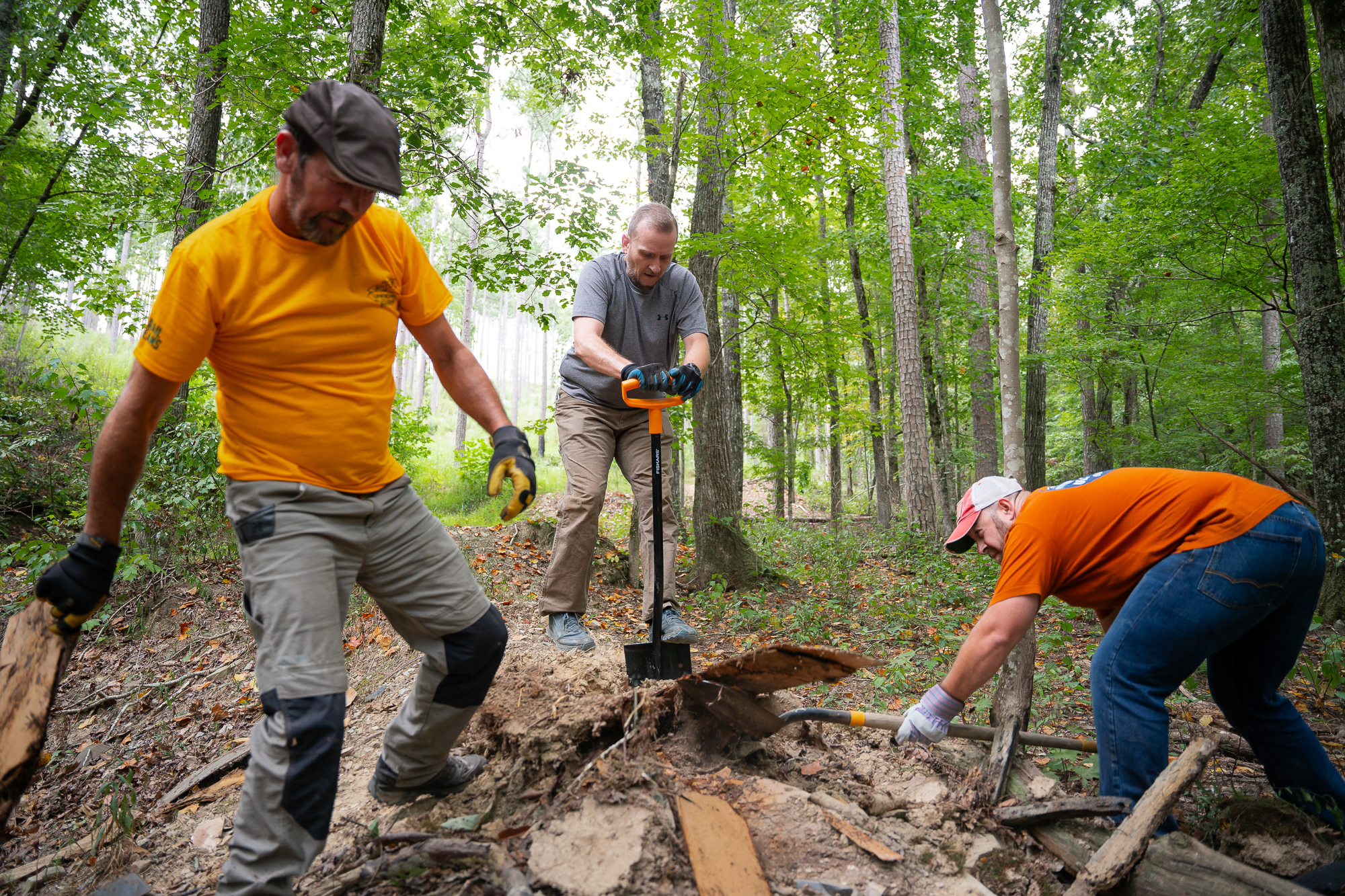
A recent example of an access initiative is when the California Dual Sport Riders cleaned up and restored access to 40 miles of trails in Frazier Park. By removing 60 trees that were blocking trail access, they effectively reopened the area for off-roaders, hunters, hikers, and other user groups. These volunteer efforts are essential to support our land management agencies—which are dealing with long backlogs of deferred maintenance and loss of staff—in keeping access open.
A current example of this is our partnership with Toyota this summer on the Trail Revival Project, a nationwide initiative aimed at combating one of the biggest threats to outdoor recreation: the loss of access due to trail deterioration, overuse, downed trees and debris, and underresourced land management organizations. By rallying local off-road groups and community members, we hope to ensure that trails remain open and accessible for the upcoming summer season. Currently, we’re planning events in California’s Mendocino National Forest, Colorado, Michigan, and Pennsylvania.
Some of the latest onX Offroad features include turn-by-turn navigation and cell coverage layers. What are some details about these features that onX users may not be aware of?
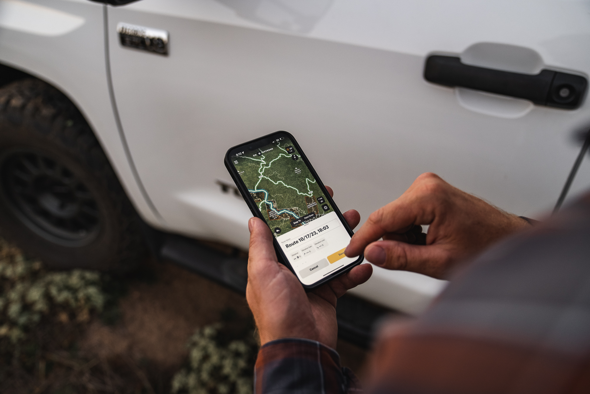
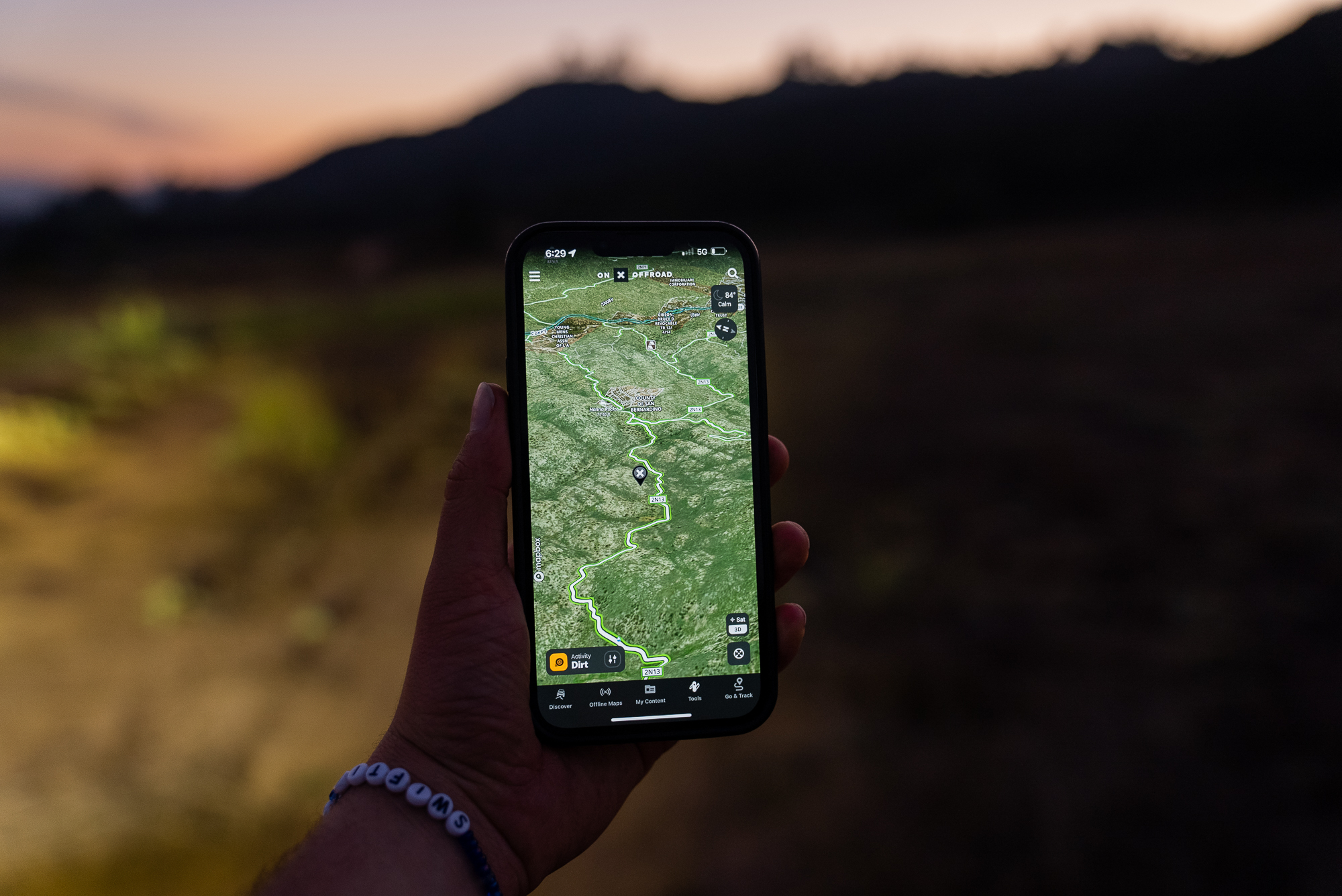
What makes onX Navigation (our integrated, voice-command, turn-by-turn tool) truly innovative is that it was built on a routing engine created in-house by our engineers. We launched our Route Builder tool a few years ago, which allows users to build a route on any of the trails or dirt roads in our app with snap-to-trail or snap-to-road functionality. So, if you click on the map to create a route, the builder will automatically trace that route to the closest road or trail. Because we built it in-house, we were able to ensure that one-way trails were accounted for (as in, you can’t build a route going the wrong way). We apply the same logic to onX Navigation. And it even works when you’re offline. So you can build a route using Route Builder or drop a waypoint and navigate to it with turn-by-turn directions even when you’re far away from cell service, no matter if you’re traveling on pavement or dirt.
As for our cell coverage layers, these are map overlays that illustrate the availability of mobile broadband and voice service from AT&T, Verizon, and T-Mobile. That data is sourced by the US FCC Broadband Map. When you add it to your onX Offroad map, it almost looks like a honeycomb of colored tiles. As you zoom in, you’ll see that each tile is a different shade of blue, pink, or purple (depending on the service provider chosen). That denotes the lowest level of service available within that tile’s coverage area, whether that’s 5G, 4G, or voice and text. onX did this to make sure our app users don’t misinterpret the entire tile as having 5G available when only part of it does. In general, this layer allows off-roaders to know when they will have service and to what level when on an adventure. If they don’t have service, they can get a sense of when they will have it again along their route. Our goal was to help increase users’ safety and confidence while out on the trails.
What is the Trail Guide program, and why is it important?
onX builds its maps from the ground up, tailoring the content to off-roading enthusiasts. To achieve this, we don’t rely solely on off-the-shelf content or random user-generated content. Instead, we contract with hundreds of trail guides across the US who are experts in the space. After going through training with onX Offroad and TreadLightly!, they map the rich content that you see on the map. They are the ones who ride the trails, save a GPS track, write descriptions, take photos, note obstacles, and add relevant information for others. From there, we have a quality assurance team that collects that information, verifying every line and trail, open and closure dates, permit needs, etc., before it’s added to the map.
Are there some new features slated for 2025 that the onX Offroad team is particularly excited about?
On May 15, onX Offroad released a new layer for dispersed camping. It is the first of its kind, a comprehensive data source of where you can legally camp alongside a road or trail on Forest Service land. When toggled on, the layer highlights road and trail segments in bright yellow where dispersed camping is allowed. When a user clicks on the road or trail, they can find details about each area’s unique regulations. By highlighting legal camping corridors on the map, rather than focusing on a limited number of marked sites, the layer will help users truly understand the vast areas where they can spend the night in nature. At the same time, it will also help campers spread out and reduce overuse, as well as our collective impact on public lands.
What is the Adventure Forever Grant, and why should people apply? What are some past projects that were awarded grants?
Because onX is part of the engine encouraging people to get outside, we believe it’s our responsibility to give back to the places that fuel our adventures. We do this through various initiatives, one of which is our grant program, which creates opportunities for off-road clubs, nonprofits, land trusts, tribal, national, and other community groups to unlock funding for projects related to access and stewardship.
Funded projects include those that acquire and conserve lands for recreation, protect access routes, build or restore trails and riding areas, build a community of stewards, or even support public access to recreation on private land. Funding amounts will vary based on project type and location, and typically fall between $5,000 and $25,000.
In 2024 (see our Impact Report), onX helped purchase 101,576 acres of land for public access, built 18.6 miles of new trails, restored 434 trail miles and cleaned up 65 acres. Some of those projects included the following grant recipients:
Two Wolf Foundation, who loaded up their off-road rigs and set out into the Bridger-Teton National Forest to help build a new trailhead that created safe access to over 300 miles of trails in the Commissary Ridge area. They also removed trash along 26 miles of trail and decontaminated 11 dispersed camping sites.
TreadLightly!, which hosted five trail projects across Michigan all in one day last June. The organization rallied dozens of off-road community members to help install 1,120 feet of new fence, improved 76 miles of trails, and removed 8,402 pounds of trash.
Venture Unknown, who gathered 14 teams across 10 states and 12 national forests (in the Southeast) to haul out 101,312 pounds of trash, including 322 tires, and cleaned 255 miles of Forest Service Roads.

One of the aims of onX Offroad is to preserve outdoor recreation opportunities for future generations. What challenges has the team encountered along the way?
In the Access and Stewardship space, onX represents many voices that don’t always see eye-to-eye. For example, onX users across our suite of apps include backcountry skiers, climbers, hunters, hikers, campers, mountain bikers, and all types of motorsports enthusiasts. While it can be a challenge to address everyone’s unique needs when it comes to advocating for public land use, it’s also an opportunity to bring user groups together to stand up for what we all want. We all have the same motivations when we get outside–whether that’s to escape, rejuvenate, overcome a physical or mental challenge, or discover and explore the unknown. By uniting together and advocating for these commonalities in experiences, we can achieve more together than we can as separate voices.
Our No Compromise Clause: We do not accept advertorial content or allow advertising to influence our coverage, and our contributors are guaranteed editorial independence. Overland International may earn a small commission from affiliate links included in this article. We appreciate your support.