
Editor’s Note: This article was originally published in Overland Journal, Summer 2020.
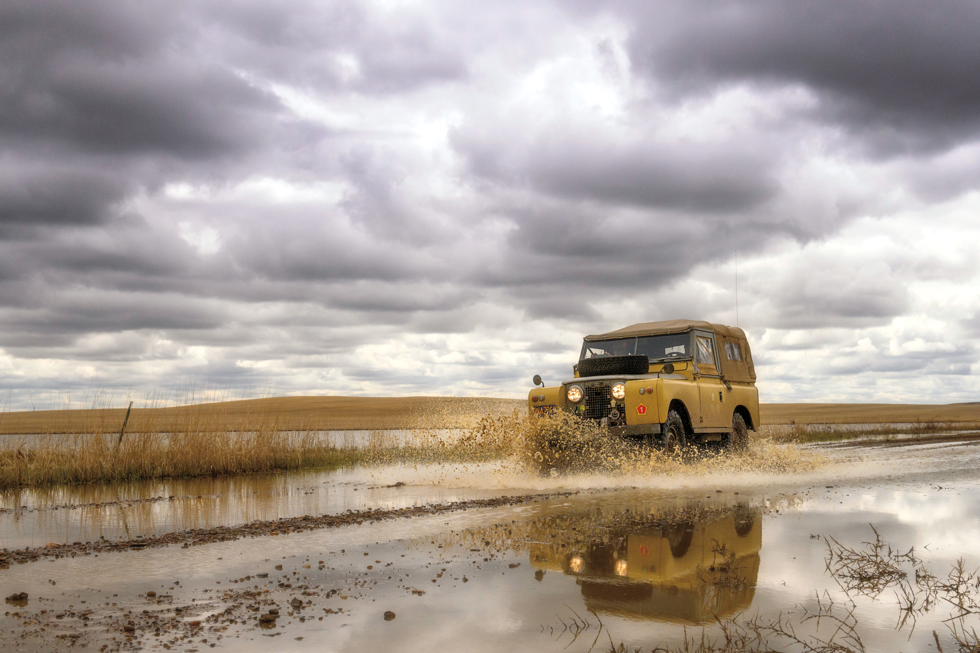
Even by the standards of Montana Land Rover clubs, this idea seemed like a pipe dream under the paired influences of Scottish ale and mid-winter cabin fever. The proposal was such: a weeklong overland foray in early May into some of the most remote country in Montana—the Upper Missouri River Breaks National Monument. We were to be powered by 50-year-old, originally equipped, 4-cylinder Series Land Rovers.
Oh, hell yes, we said. We’ll see it all, the whole 3.5 million acres. We’ll chase buffalo over cliffs with those old rigs, plunder dinosaur fossils. And cross the Missouri in log rafts if we have to.
The expectations were unrealistic, but with a little deferred maintenance on the trucks, we might pull this off. Still, we knew there would be obstacles. There’s a reason the natural east–west overland route, known as the Hi-Line, skirts well north of the Missouri Breaks, close up against the Canadian border. Indigenous people used that route over thousands of years, and the first wheeled vehicles to enter present-day Montana were the Red River carts of mixed ancestry Métis traders out of the Dakotas, possibly in the 1820s. Later, Great Northern Railroad and US Highway 2 surveyors would select this route as well.
A bit south of the Hi-Line, the Breaks country is deep, braided canyonland, much of it unpenetrated by roads of even the loosest definition. Tributary rivers and streams cut in from north and south, creating an inhospitable landscape that greatly hinders overland travel anywhere near the river. All the bottomland and most of the tributary side canyons are protected under provisions of the Wild and Scenic Rivers Act, and later national monument status. Several national wildlife refuges and huge blocks of Bureau of Land Management public properties make the Breaks one of the largest, most remote, and forbidding overland destinations in the Lower 48. Like the fur traders from two centuries past, most visitors today see this country from the river.


A late spring trip two years earlier with club member Jason Swant left us both in awe of the Breaks. That modest trip in Series trucks offered up a share of technical driving over rain-slickened ranch roads, raw beauty, and adventure in a new setting. Our appetites were whetted for another bite, and we found the small group of Montana-based Land Rover enthusiasts willing to take it on, possibly because of the restriction to 4-cylinder Series Rovers. “Wherever they are,” one member said, “those old Land Rovers just look like they belong there.”
The Upper Missouri River is hugely influential in Montana— historically, culturally, and, for our purposes, geographically. Along Montana’s north–central tier, the river generally runs west to east from Fort Benton, the uppermost navigable port for 19th-century riverboats, to the sprawling Fort Peck Reservoir 150 river miles downstream.
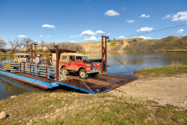
For many decades, the crossing at the earthen Fort Peck Dam and a drawbridge at Fort Benton were the only spans across the Missouri River along Montana’s Hi-Line. Plains Indians also had few places to ford the big river, and notable battles occurred here during the riverboat era. The Badlands of the northeast side became a famous hideout for outlaws such as Kid Curry of Wild Bunch fame. The only other crossings of the Missouri were by seasonal ferries, which may have numbered six or more over the years—three remain in operation today.
A major goal of our group is to cross the Missouri River on at least one of these remote historic ferries. Another is to simply survive the elements, the logistics, and the vagaries offered up by these vintage Land Rovers when dropped into a forward gear.
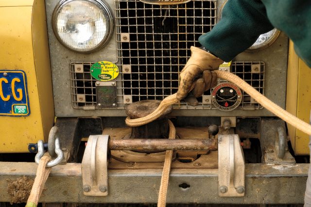
Our to-do list is daunting. We’d already pulled an engine and transmission to change out seals—one appears to be original leather, and smells vaguely of beef jerky. We perform clutch replacements, bearings and brakes, and, sweetest of all, suspension and frame bushings all around in Kern Kemmerer’s 1970 late IIA 88.
Standing over a transmission and transfer case on the Swant’s garage floor two weeks before departure, we are resigned to allow a support vehicle to tag along. Two “modern” Rovers are volunteered: a Defender 90 and a Discovery I, which we load to the roof racks with jerry cans, water, firewood, emergency spare parts out of Rovers North, and miscellaneous provisions, including plenty of Harvest Moon beer.
We depart Helena just as Wayne and Kathy Phelps pull in from the Portland area in an enviable 1963 88 under a full canvas top. Eighty miles later, we rendezvous with Matt Mc- Cune out of Bozeman, also in a 1963 IIA 88. The contingent is five of these short Series trucks with Josh Kemmerer driving his father’s Defender. Kyle Stugill-Simon later joins us in a Disco I.
We throw snowballs around at Kings Hill Summit while the rigs cool and overflow coolant from the pull to 7,300 feet. The descent carries us through a limestone canyon that coughs us out onto the plains.
Central Montana unfolds as we drive a dirt road north, ascending the flanks of the Highwood Mountains, an island range with a view straight across to Round Butte and Square Butte to the east. These are iconic geologic features for a hundred miles around, standing as backdrops to generations of snapshots, tintype images, and the landscape paintings that preceded them. Rising almost 3,000 feet above the surrounding plains, these buttes are igneous formations known as shonkinite, found in only a few locations worldwide. Eons ago, molten rock, rich in iron, was forced up from the mantle and into overlying layers of sedimentary rock where it spread out horizontally. As the softer rock weathered away, these impressive formations emerged.


Elk and mule deer were abundant here as we dropped down into the federally protected Waterfowl Production Area at Kingsbury Lake, a part of the National Wildlife Refuge System. This is our entry into the “sag” country of the Breaks just outside of the tiny town of Geraldine. The shallow lake is an important migratory bird stopover place, but spring is late this year, and snowdrifts persist in the gullies and along ridgelines. We see mostly owls.
In Montana, sags are the former river beds of the Missouri. The repeated advances and retreats of Pleistocene ice sheets shoved around the Big Muddy, forming giant lakes behind fragile ice dams. These glacial lakes burst numerous times over the ages, flooding and scouring today’s Missouri River Breaks. The course of the Missouri River along the Hi-Line roughly follows the leading edge of these repeated glacial advances. Grain farmers in Montana and North Dakota regularly thank these ice sheets for bulldozing Canada’s rich topsoil onto the US side of the border.
We wake to an inch of snow at our camp in Geraldine and adjust our plans. Instead of undertaking a likely one-way trip down into the Breaks, we choose to push north through the Shonkin Sag toward the long-defunct Missouri waterfalls at Lost Lake. Crossing the Highwoods, we encounter fresh snow.
Landowners at Lost Lake are generous and allow visitors to walk out (at your own risk) and view one of Montana’s great natural features: the 300-foot cliffs of the dry waterfalls, almost a mile across, and the sink of saline water that pools at the base. These columnar cliffs are also comprised of hard shonkinite rock.
We drop into the historic town of Fort Benton to gas up and return to our camp in Geraldine, where we collect Kyle Sturgill-Simon in his 1997 Disco. In the morning, we strike out for the White Cliffs of the Missouri, oftentimes fording spring-flooded roadways, raising up long-billed curlews and American avocets as we splash through.
Later, we approach Slaughter River, another private inholding on the Missouri. The Lewis and Clark Expedition camped here twice, once in the spring of 1805, and again on the downstream run a year later. The pair named a significant tributary coming in from the south Slaughter, although the incredibly winding drainage is now ironically called Arrow Creek.
The drop from the bench to Slaughter is dicey. The landowner had told me over the phone, “There’s only one way in and out. If it rains, you might be there awhile.” The two-track is greasy as hell on the steep low-range descent. The abandoned old homestead at the bottom is a marvel of dashed dreams and gargantuan rusted farm equipment, some of which could only have arrived by river barge. We make a delightful camp and grill salmon with wild rice, and toast our luck with Islay Scotch whisky.
Although Slaughter River is only about 10 air miles from our next planned camp at the confluence of the Judith and Missouri rivers, record ice jams a few weeks earlier have taken out the only bridge crossing Arrow Creek. We backtrack and ride a bit of highway to push north again to the Judith River, named by William Clark for his future wife. Weather closes in on us as we seek permission to camp on private ranch land along the Judith River bottomlands. The dense cottonwood galleries along the water stand in stark contrast to the Missouri, whose banks are void of young trees. Hydroelectric dam releases from upstream and the relentless spring ice jams prevent young cottonwood trees from taking hold.
We are quite sheltered on the Judith, and the evening air is filled with the breeding calls of plains spadefoot toads, wild turkey, and pheasant. As we climb switchbacks onto the bench the next morning, we find ourselves in the teeth of another Montana spring snowstorm.
Like Geraldine, the little town of Winifred is a gateway to the Breaks and offers camping at its park. Townsfolk are friendly and informative. We are told the ice jams have taken out the Stafford–McClelland Ferry north of town. This is a disappointment as we wait out the storm, fussing over plan revisions. We take the opportunity to make minor repairs and check the boxes on the hardworking trucks. A Series 2.25-liter engine can build 74 horses on a good day. All five have known better days, yet each rig performs perfectly, particularly given the loads and grades.
As the road dries, we approach Judith Landing and the American Prairie Reserve’s (APR) 50,000-acre PN Ranch. Managers of the reserve welcome self-contained overlanders at this and several other large additions to the east. The APR also offers accommodations in yurts at the various properties, as well as a developed campground at Antelope Creek. The APR works to restore native shortgrass prairie ecosystems and currently wants to convert some of its cattle leases on BLM lands to bison. It’s not without controversy, and we see occasional signs that read: “Save the American cowboy. Stop the APR.”
The APR’s ranch manager suggests an informal campsite in the Judith River cottonwood bottoms. We hurriedly set camp and make for an evening foray, once again along a former Missouri River channel known as Big Sag. Our photographer, Chris McGowan, hikes to several high points for shots as the old trucks spread out in the gloaming and sage.
The next day we work our way upstream to a ferry crossing at historic Virgelle. The Missouri River ferries are operated and maintained by the respective counties, and there is no charge. Just ring the bell at the water’s edge, and the ferry master will eventually arrive to board the vehicles. Ferry operator Jimmy Griffin walks a couple hundred yards from the Virgelle Mercantile and antique store. At other crossings, the operator might be hailed from a farm tractor. The ferries offer a dramatic river crossing of the Missouri, although perhaps somewhat less so than a cottonwood raft.
That gap between wild expectation and raw experience is a certainty. You can plan an adventure, but you get what the country and the conditions yield. As we worked around broken bridges, blown-out passages, and morphed plans, those faithful old Land Rovers just kept plugging away and seemed to maintain an appetite for more.
The geology, history, and full expanse of the Missouri River Breaks can be overwhelming, particularly under Montana’s famous Big Sky. We move like rolling dust specks across this untamed setting, with one eye cast toward the past, and a light foot on the throttle to whatever the world serves up next.