OnX Offoad Shows the Way
Navigating the Hatfield-McCoy Trail (HMT) System, with its over 1000 miles trails will soon be easier. Navigation app developer onX Offroad and Hatfield-McCoy are partnering up to improve the user experience in the forests of West Virginia. Adding the Hatfield-McCoy to onX Offroad’s 600,000-plus miles of mapping data will improve user safety and minimize navigation problems.

Current phone apps aren’t much good in the woods, says HMT Executive Director Jeffrey Lusk. “Quite a few of our trails are in areas with little or no cell service, which makes traditional navigation impossible. The onX Offroad Application will change all that.”
A Better App
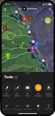
onX Offroad users can download maps to use offline, including finding their exact position via their phone’s GPS. That’s the kind of certainty that makes exploring a little less adventurous, but a lot safer.
John Fekete, Deputy Executive Director of the Hatfield–McCoy Trails, is impressed with the app’s offline capabilities. He stated that, “For years, we have provided downloadable trail maps for offline use, but this app provides a simplified, directional navigation view of the trail while driving. That’s a real game changer.”
It’s All on Your Phone
 Beyond the pinpoint location data available with the onX Offroad app, users will also find a host of Hatfield-McCoy trail data. Information on trail difficulty, various map views, and recreation point details for lodging, river access, trailheads and
local businesses will be at their fingertips. Trail riders can also add custom waypoints for anything interesting, such a campsites or obstacles.
onX Offroad Data Accuracy
 onX Offroad General Manager, Rory Edwards stated, “We are proud to become the official navigation partner, combining the East Coast’s preeminent trail system, the Hatfield-McCoy Trails, and onX Offroad’s GPS App technology.” A big part of that is providing users with accurate and easily obtained trail data, “So they can make the most of their time out there, enjoying routes and exploring the largest trail system in the world.”
 Given that the Hatfield-McCoy Trails are often in flux due to changes in land use agreements, that’s a tall order. Having HMT personnel involved with onX Offroad’s geospatial crew allows an expert to ensure accuracy. “Riders can be misled by user–generated and unverified mapping information,” said HMT’s Marketing Consultant, Chris Zeto. “Right now, folks are selling unsanctioned trail maps and even pre–loaded tablets that can contain unreliable and outdated mapping information. These maps can get you lost or, in some situations, lead you to private and posted lands as an unwelcome visitor. Now riders have an app they can depend on.”

Our No Compromise Clause: We carefully screen all contributors to ensure they are independent and impartial. We never have and never will accept advertorial, and we do not allow advertising to influence our product or destination reviews.


