
We first discovered the Baviaanskloof Mega Reserve (also known as the Baviaanskloof Wilderness Area and recognized as a UNESCO World Heritage Site since 2004) in 2011 after returning home to South Africa from a journey to Kilimanjaro in our 2003 Land Rover Defender 130. We fell in love with the untamed beauty of the remote area, and it became our go-to adventure route for camping, off-road driving, campfires, stargazing, and hiking. Upon our return to South Africa, after eight years on the road in the Americas, Europe, and Western Africa, we made a beeline for the Baviaanskloof. We were pleasantly surprised to find that it was even more beautiful and rewarding to travel than we had remembered. Exploring the Baviaanskloof and the surrounding areas is like stepping back in time to a place where doors are open, people are friendly, wildlife roams, and your soul is free to breathe, where the cool air of the Indian Ocean meets the golden warm breath of the Karoo, itself an expansive semi-desert without clear definition or borders.
General Information
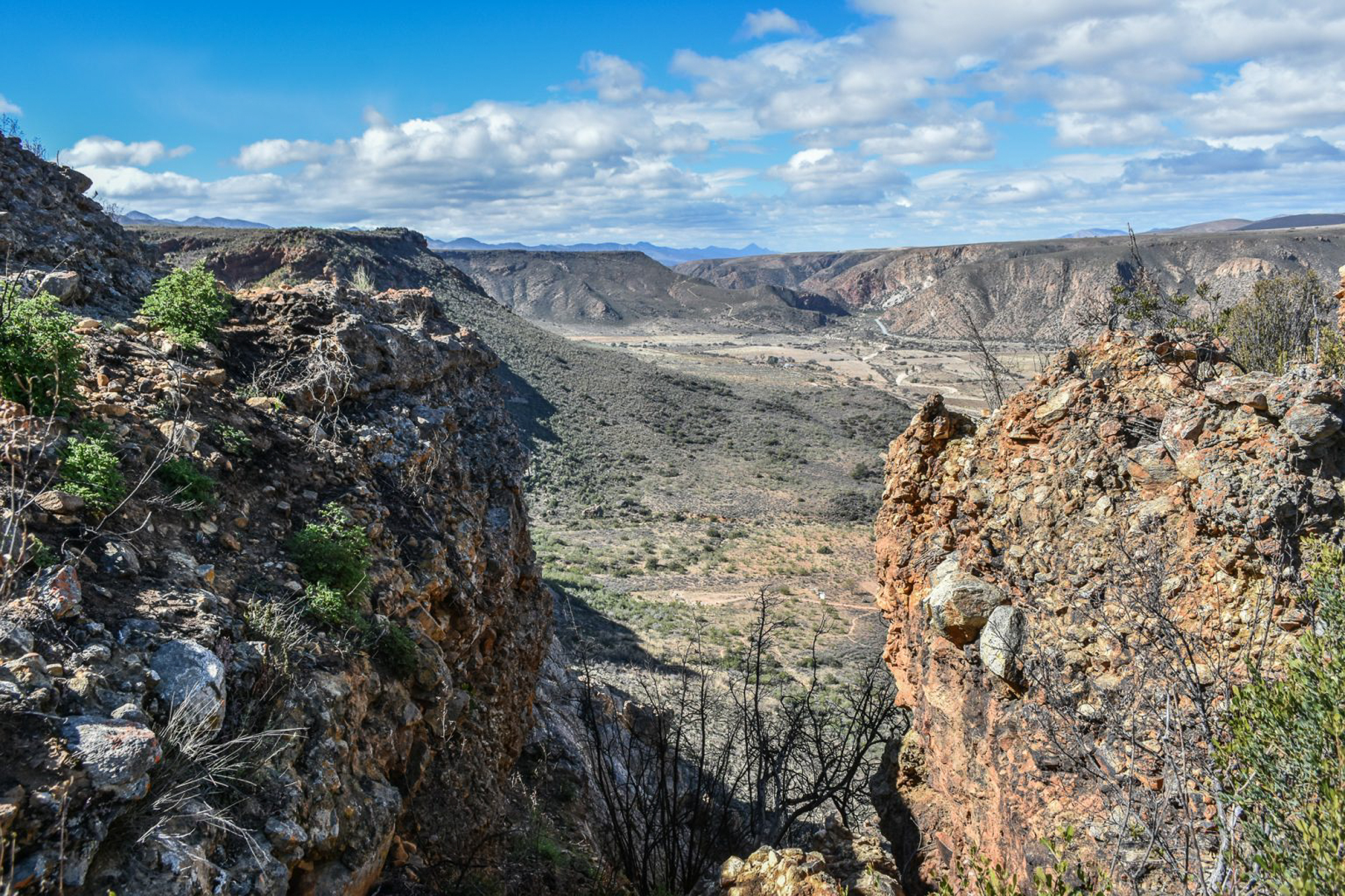
The name Baviaanskloof is rooted in the Dutch phrase “Valley of Baboons,” and the reserve is a haven of mostly untouched nature, winding gorges with steep mountain passes, expansive grassland plains, sweeping views of pristine wilderness, and flowing streams. Over millennia, these flowing streams, which at times become voracious rivers, have sculpted this landscape where human presence can be traced back over a million years; South Africa is considered the cradle of mankind. It’s a pleasure.
This narrow valley, stretching almost 124 miles, is nestled between the Baviaanskloof Mountains to the north and the Kouga Mountains to the south, sitting at a lower elevation than the Karoo. Rainfall seeps through these mountains, feeding the Baviaanskloof River and giving rise to a lush valley rich with diverse plant life with over seven of South Africa’s nine biomes present, feeding agriculture until the river ends at a confluence with the Kouga River, nearly 50 miles from its source.
The Baviaanskloof region features a network of protected zones overseen by the Eastern Cape Parks and Tourism Agency, covering approximately 500,000 hectares (1,200,000 acres). The largest among these is the Baviaanskloof Nature Reserve, which spans 184,385 hectares and is the third-largest protected zone in South Africa. Also part of this cluster is the Baviaanskloof Forest Reserve, established in 1920, along with the Groendal Nature Reserve and Formosa Nature Reserve. The area also encompasses sections of private land, many offering campsites and accommodation ranging from basic to glamping. Visitors are encouraged to circle back along the coastal route, regardless of the starting point of the trail, as the coast offers many hidden and not-so-hidden treasures, such as the Storms River National Park and the Bloukrans Bridge with the terrifying 710-foot bungee jump (never again, thanks). Beach lovers will enjoy Jefferys Bay, renowned among surfers as a top destination, thanks to the right-hand point break at Supertubes Beach, made famous in the 1966 movie The Endless Summer.
The Drive
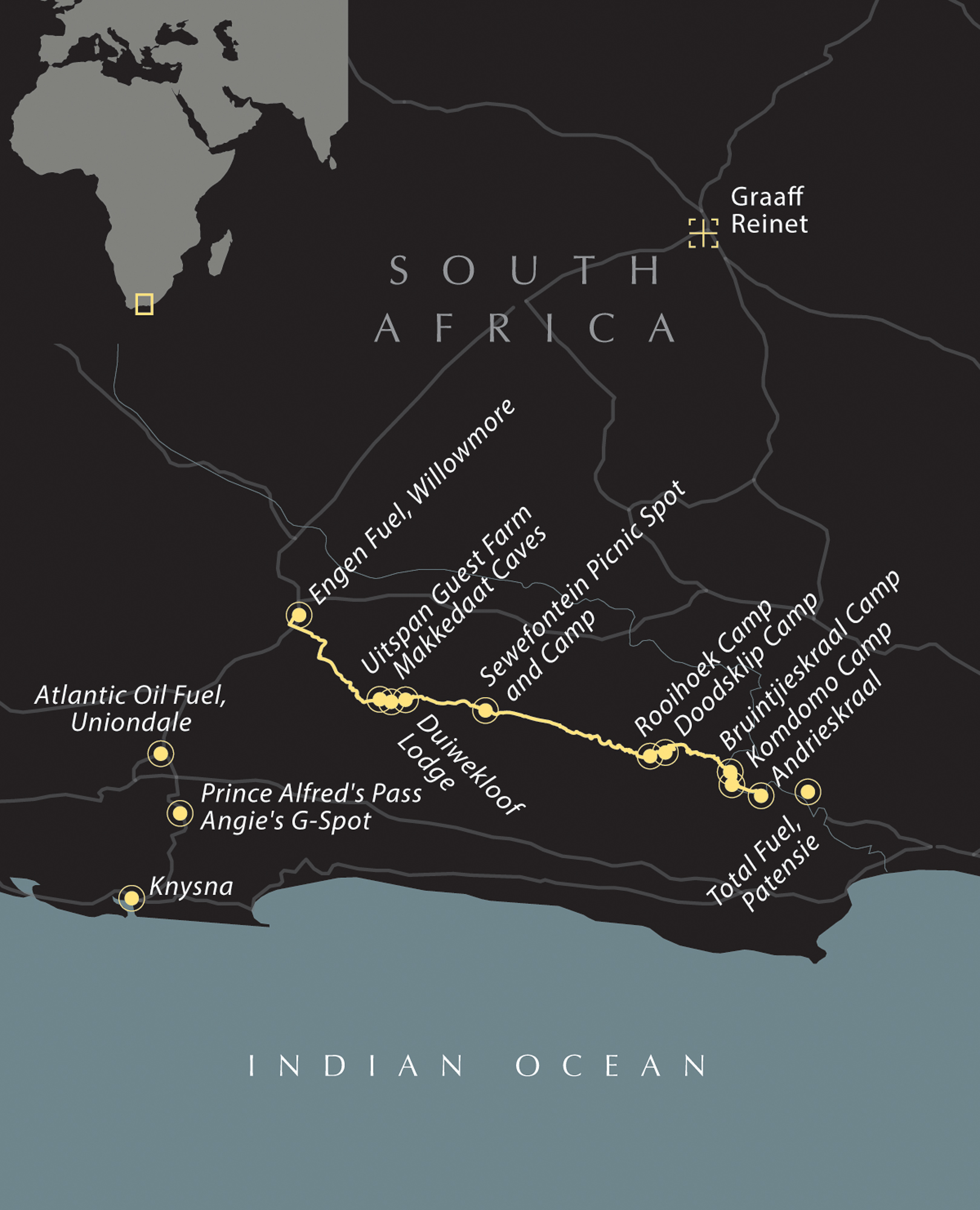
There are two options to enter the Baviaanskloof Mega Reserve, either from the west with an approach from Willowmore or Uniondale (fill up with fuel here) or from the east and the delightful farming community of Patensie (fill up with fuel here), where stark mountains frame rolling hills of verdant farmlands.
Our starting point is usually the coastal towns of Plettenberg Bay or Knysna (considered two of the most beautiful coastal towns in Africa and, thus, the world). We would travel over Prince Alfred’s Pass (R339) through the Tsitsikama Forest, where wild elephants once roamed (now only one lone adult female remains), to Uniondale, and then toward Willowmore. Prince Alfred’s Pass is itself a route worth exploring, climbing 43 miles from the ocean to the interior; it holds the distinction of being the longest publicly accessible mountain pass in South Africa and the second oldest unmodified pass still in use. Halfway through Prince Alfred’s Pass, you can stop at Angie’s G-Spot, the cheekily named campsite where a cold drink and basic accommodation are guaranteed. From here, the more adventurous traveler can head down to Die Hel (The Hell), also known as the Gamkaskloof, a narrow, isolated valley spanning 16 miles where a small community lives; it’s accessible only by robust vehicles. Those choosing to skip Die Hel (or returning from it) can continue driving Prince Alfred’s Pass to Uniondale and the R332 road that leads into the Baviaanskloof. The road between the end of Prince Alfred’s Pass and the R332 is paved, scenic, and often devoid of traffic, save for a few farmers.
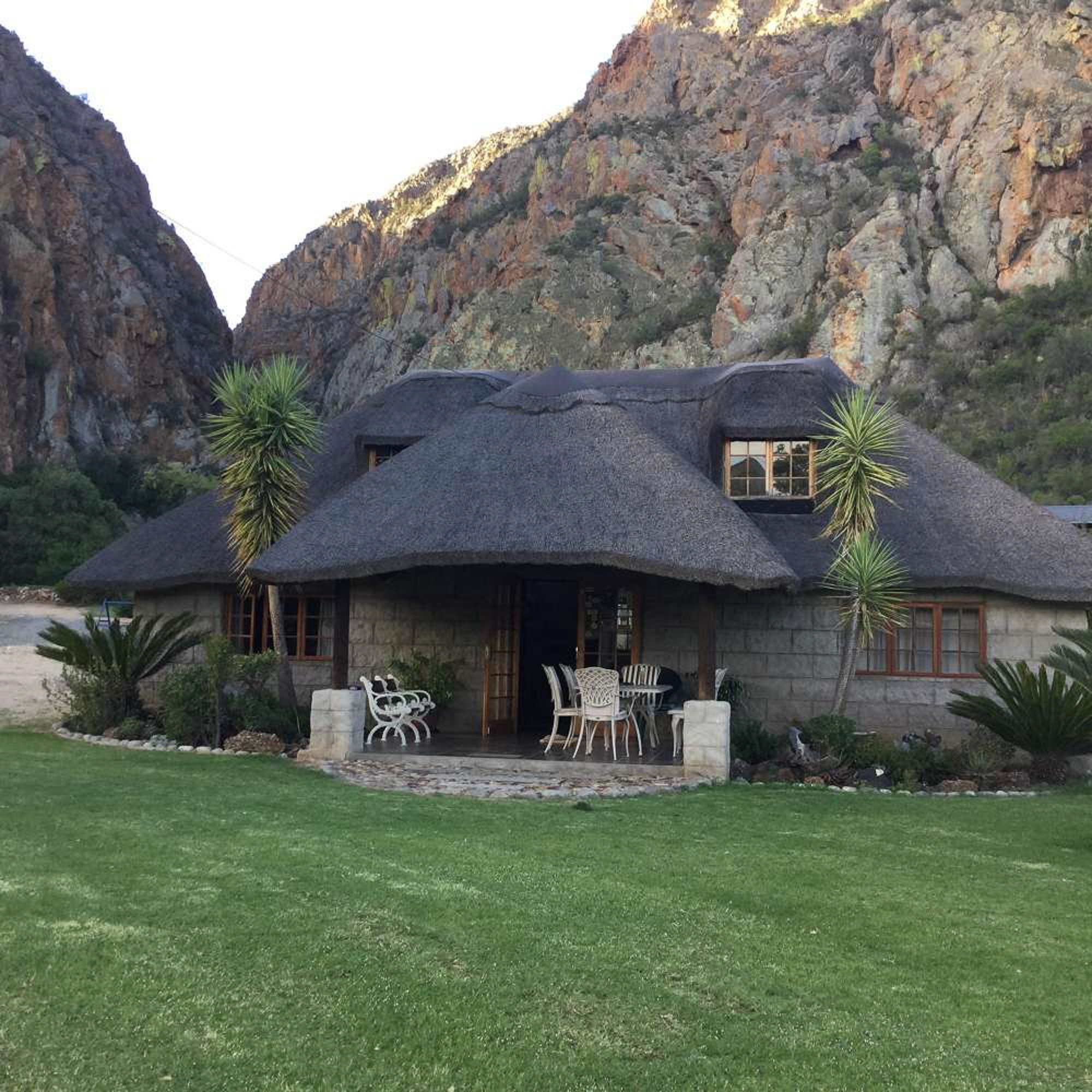
The unpaved R332 route is accessible by lowly sedan vehicles for the stretch between Willowmore and Zandvlakte (the location of the national reserve gate), a distance of about 60 miles along which excellent accommodation can be found. This road can sometimes be heavily corrugated and moderately flooded during heavy rains as many streams meander beside and across the road. The locals, mainly Afrikaner farmers, and their workers, descendants of the Khoisan people, are friendly and eager to offer assistance, directions, or recommendations if required and opened two Baviaanskloof Interpretive Centres in 2022 at either end of the reserve featuring modern info hubs, conference rooms, immersive virtual tour platforms, administrative offices, kitchens, cafeterias, restrooms, parking areas, and a covered terrace. Zandvlakte is the location of the western Baviaanskloof gate, beyond which only 4WD vehicles can venture. Before entering the Baviaanskloof (or after if traveling from the east), we would be sure to spend a night or two at the Uitspan Guest Farm, where we would camp, hike to explore the canyons, and enjoy a campfire and hot shower. The campsites here are world-class, and each has a covered area with a built-in braai (barbeque grill), sink, water supply, and electricity.
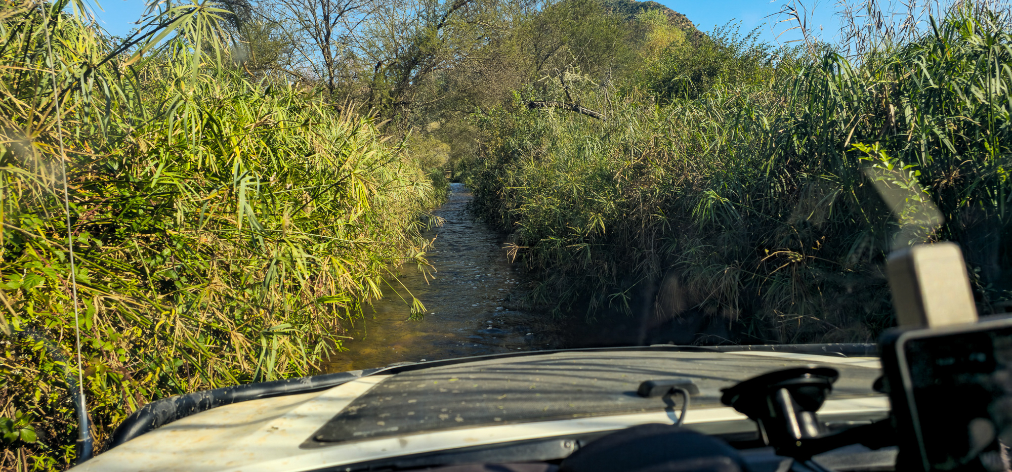
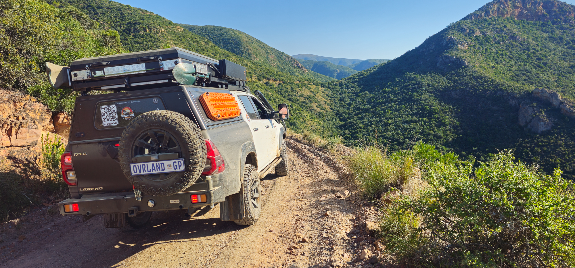
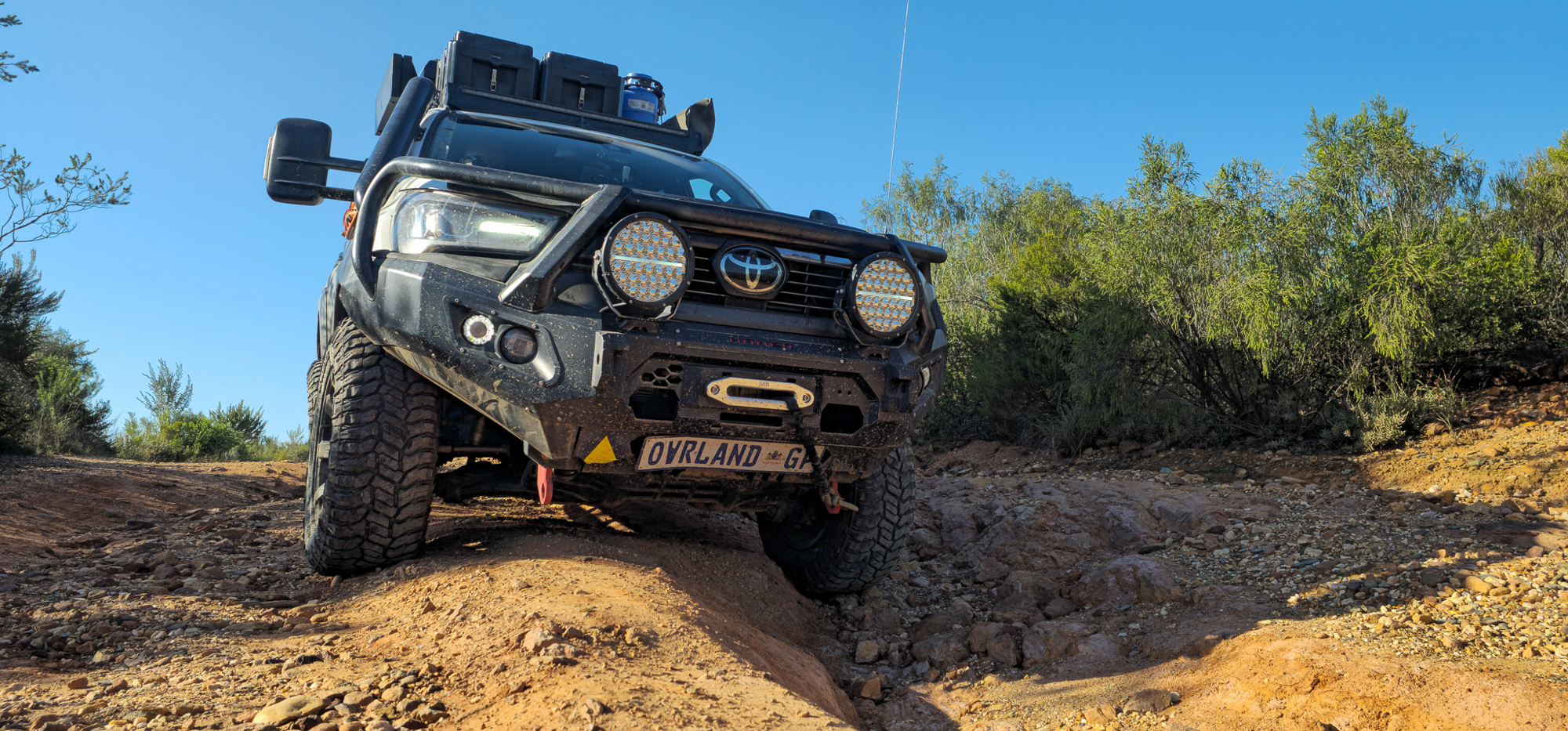
You can enter the reserve and begin your adventure after paying the nominal park fee and registering your personal and vehicle details. The route is 4WD exclusive between Zandvlakte and Poortjie (between the two reserve gates), as there are numerous river crossings and steep mountain passes. Low range is only required if the water crossing is particularly deep during the rainy season, but that is merely a precaution as most river beds have long since been paved during the dry months. Winter flooding has damaged some of these submerged concrete roads, and in sections, you may find a wheel dipping alarmingly; in this case, it is best to reverse and try another line. Airing down your tires is also only really necessary to improve the comfort of your drive, as these roads are not maintained except for occasional repairs due to flooding. Most river crossings and animal sightings are found on the trail’s lower, western portion. In the past, we have spotted Cape mountain zebras, greater kudus, common elands, savanna buffaloes, and red hartebeests (two of which surprised us once when we stopped for a romantic picnic), along with playful vervet monkeys, rock hyraxes (dassies), small grey mongooses, and troops of savanna baboons, from which the valley gets its name. Leopards have also been spotted. From the valley and after the river crossings, some of which can be quite overgrown, long, and deep, the ascent will begin at the top of the Kouga Mountain Range. Before the ascent, there are two national park campsites, namely Rooihoek and Doodsklip; both are basic with limited amenities and plenty of wildlife (bookings must be made at either entrance to the reserve).
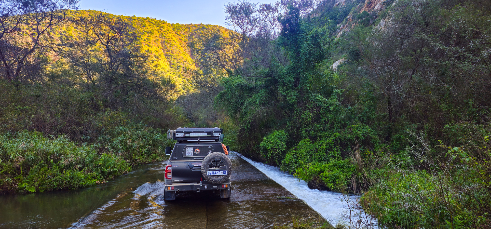
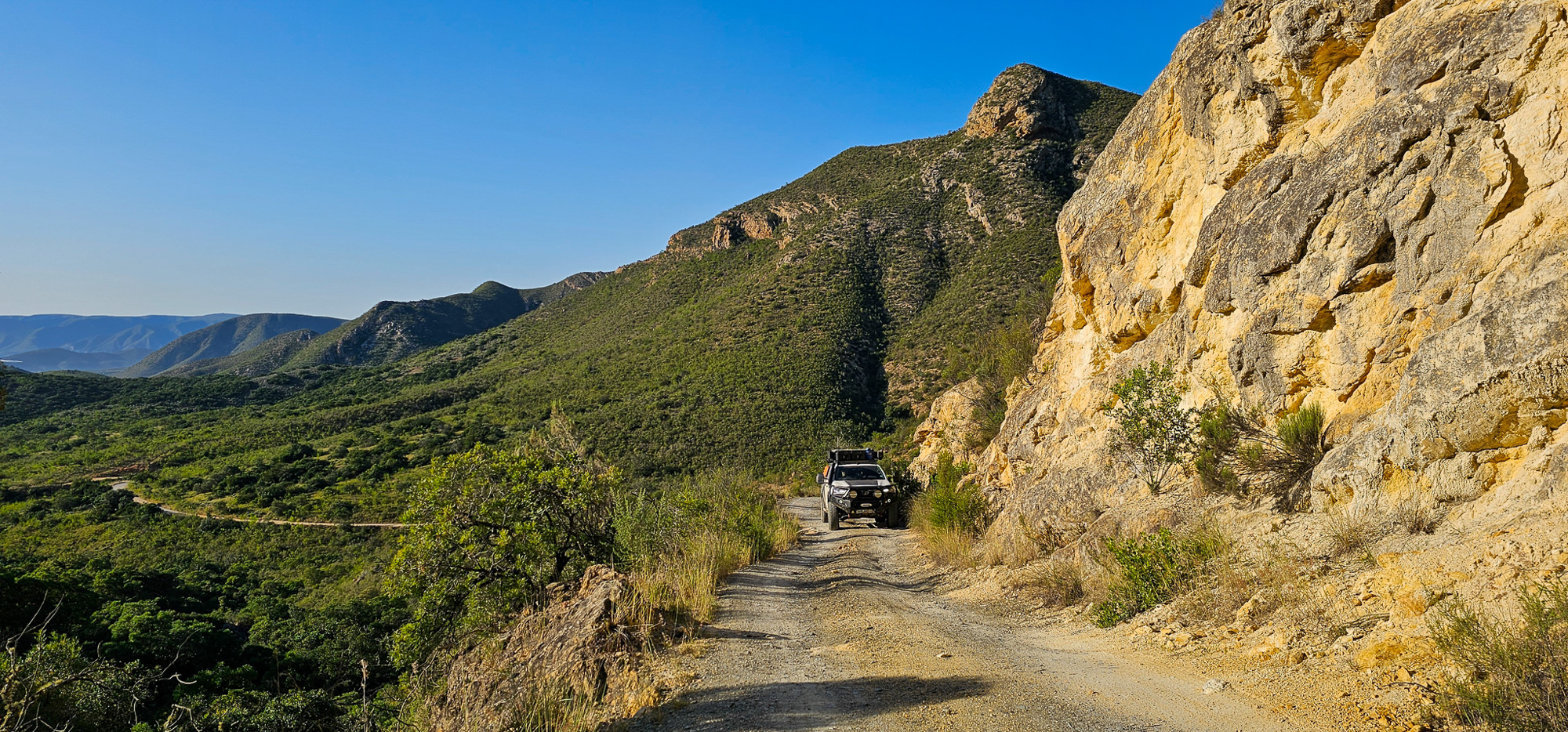
Generally, the ascent (or descent, depending on your starting point) road is in relatively good condition, and there will occasionally be areas wide enough to allow approaching or faster vehicles to pass. I will never understand why some rush the pass; taken at a leisurely pace, it is possible to travel from gate to gate within seven or eight hours. The climb is at first winding and moderate, interspersed with a few steep and heavily rutted and eroded sections to get the heart beating a little faster. Those with a fear of heights (like our Luisa) might want to hold on tight when the trail enters the mountain pass that leads to Patensie. The drops are steep and should be approached respectfully, as there are only natural barriers to avoid a disastrous plunge. The views are, however, sublime and well worth the drive. After a satisfying day, one arrives at the eastern gate and a few options for camping. We choose to camp beside Groot River at Bruintjieskraal, which offers a choice of large sites equipped with gas showers, campfire areas, and toilets. You might find yourself sitting beside the fire after a swim in the river, with a cold drink in hand, seriously contemplating heading back the following day and doing the route again. We highly recommend exploring the area for as long as possible as there are many routes to investigate excellent campsites and chalets to enjoy.
Access
West Entrance From Knysna, travel north on the R339 up the Prince Alfred’s Pass to Uniondale for 49 miles. Take N9 north towards Willowmore for 36 miles. Before reaching Willowmore, turn right onto the gravel road marked R332 and drive 33 miles to the entrance of the western gate of the Baviaanskloof.
East Entrance From Gqeberha (Port Elizabeth), travel west along the N2 for 27 miles and take the turnoff to Thornhill. From Thornhill, travel west on the R331, which merges with the R332 for 49 miles, to the east gate of the Baviaanskloof.
Logistics
Total Miles 124 miles
Suggested Time 2-4 days
Longest Distance Without Fuel 124 miles
Fuel Sources
Total, Patensie 33° 45’26.7″ S, 24° 48’45.5″ E
Agrimark, Patensie 33° 45’26” S, 24° 48’44” E
Engen, Willowmore 33° 17’33” S, 23° 29’22” E
Difficulty (3.0 out of 5.0)
Four-wheel drive is compulsory for entry into the national park; however, the trail can be explored most of the year with a high-clearance vehicle. With rainfall, the road can be slightly more difficult to navigate as there are over 40 river crossings.
When to Go
Any time of year is good, but spring and fall are the best times to visit as the summers are hot and the winter nights are cold. Weekends are moderately busy with locals; from Monday to Thursday, you will have the area mostly to yourself.
Permits and Fees
All day visitors to the Baviaanskloof Nature Reserve must purchase a permit: R40.00 ($2.20) per person; children under 12 are R25.00 ($1.40) each. The gates open at 5:00 a.m. and close at 4:00 p.m.
Suggested Campsites
LOCATED WITHIN THE RESERVE
Rooihoek, 33° 37’12” S, 24° 08’30” E | Five riverside campsites located on the eastern side of the reserve; basic amenities, opportunities to view wildlife
Doodsklip, 33° 37’48” S, 24° 10’12” E | Basic campsites with long drops located on the eastern side of the reserve
Komdomo, 33° 44’21.84″ S, 24° 36’51.30″ E | Lovely lawned campsites next to the eastern entrance to the Baviaans; grills, water, electricity, full bathrooms
PRIVATE CAMPSITES OUTSIDE THE RESERVE
Bruintjieskraal, 34° 2’33.36″ S, 19° 18’30.24″ E | Fourteen campsites situated along or close to the Groot River; private ablutions, barbeque areas bruintjieskraal.co.za
Makkedaat Caves, 33° 38’14” S, 23° 59’0″ E | Unique cave accommodation (self-catering cabins) built into the side of a mountain; barbeque and kitchen facilities makkedaat.co.za
Duiwekloof, 33°35’26” S, 24°24’53” E | Large shady campsites; water, electricity, private barbeque area duiwekloof.co.za
Uitspan Guest Farm, 33°39’0″ S, 23°58’0″ E | Self-catering cottages with beautiful campsites based on the western side of the reserve; lapas/covered barbeque areas with electricity and water, playground, pool, lake, hiking trails baviaansuitspan.co.za
Additional Information
There are no ATMs within the reserve, so make sure to carry cash. There is limited mobile reception along the route and no grocery stores. Pets are not allowed within the reserve. Carry food, water, and fuel for the duration of your stay.
There are several mountain biking trails and hiking options, the longest hiking tour being the Leopard Trail, a four-day, three-night hike with slackpacking.
A trail map will be provided when purchasing your permit at the gate to the Baviaanskloof Mega Reserve, and Tracks4Africa offers a GPS map of the route.
Contacts
Baviaanskloof Tourism Board, baviaans.co.za, 083-420-5434
Gamtoos Tourism Board, baviaans.net, 042-283-0437
Police 10111
Ambulance 083-578-7556
Resources: Baviaanskloof Mega Reserve
It is recommended that the traveler utilize redundant GPS devices (like a phone and a dedicated GPS), along with paper maps and a compass. This track, along with all other Overland Routes, can be downloaded on our website at overlandjournal.com/overland-routes/.
26 Overland Route descriptions are intended to be an overview of the trail rather than turn-by-turn instructions. We suggest you download an offline navigation app and our GPSX track, as well as source detailed paper maps as an analog backup. As with any remote travel, circumstances can change dramatically. Drivers should check road conditions with local authorities before attempting the route and be ready to turn back should extreme conditions occur.
Editor’s Note: This article was originally published in Overland Journal’s Summer 2025 Issue.
Our No Compromise Clause: We do not accept advertorial content or allow advertising to influence our coverage, and our contributors are guaranteed editorial independence. Overland International may earn a small commission from affiliate links included in this article. We appreciate your support.