

(Editor’s Note: This article was first published in Overland Journal, Winter 2007 Issue)
Journal Entry, March 29, 2007
It is 2:30 a.m. The temperature outside the canvas wall of the rooftent is 50 degrees below zero Fahrenheit.
I retreat deeper into my sleeping bag, drawing my arms across my chest. I’m drifting between restless sleep and half-awake shivering; the slightest movement sucks frigid drafts around my face and neck, causing me to cough, lungs rebelling against air cold enough to injure them.
I am startled to alertness by what at first feels like a strong earth tremor, or a furious blast of wind. The truck and tent are shaking. Finally I realize that Pasquale, in the bag next to me, is shivering violently, interspersed with bouts of deep coughing.
“Pasquale! Are you okay?” I ask. He responds through chattering teeth, “I split out the zipper in my bag, and I can’t feel my legs.”
Fully awake now, I immediately yell to Chris, sleeping in the other tent mounted on the trailer. “Chris, get up! We need to get out of here, now!”
The Ends of the Earth
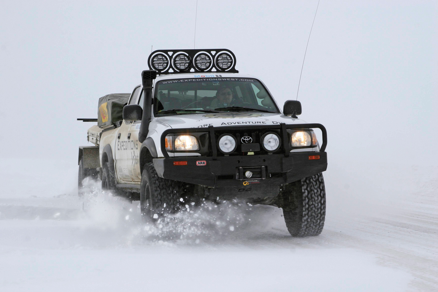
There has always been something about distant places that resonates deeply within the adventurer. A mountain summit, a coastline, the end of a road—all pull at us, inspiring the commitment and sacrifice necessary to continue past the horizon, or beyond another false summit. An end is a goal, and in our case, the end was Tuktoyaktuk, the last vehicle-accessible human outpost in northern Canada, over 230 miles north of the Arctic Circle, clinging to the edge of land and the start of the frozen ocean. The final stage ofour route would take us down the ice road on the Mackenzie River, which each year freezes solidly enough to support 18-wheelers.
Getting to Tuktoyaktuk was not easy; in fact it took over 3,000 miles and eight days of solid driving to just reach Whitehorse, in the Yukon Territory. From Prescott, Arizona, we drove north, over Hoover Dam, through Las Vegas and another 200 miles beyond to our first camp, in Utah. Before sunrise, we were on I-15 again, and into Salt Lake City, where we had lunch with Paul May of Equipt Outfitters. I have always enjoyed meeting up with friends and other adventurers along a road trip.
Next was Idaho, and then Jackson, Wyoming, and the Gun Barrel Steak and Game Restaurant, which served without question the most impressive cuts of buffalo and elk I have enjoyed outside of my uncle’s Brady-Vekol Ranch. Stuffed and tired, we camped along the Snake River and for the first time used our arctic bags. We only had the liners left for additional warmth, and still another 40 degrees of temperature drop to deal with.
One of the highlights of the trip north was a stop at American Expedition Vehicles (AEV), and a day on the trail with Dave Harriton and their two Icelandic expedition vehicles. The specially prepared Jeep Commander and 4-door Wrangler were built to support a glacier crossing and kayak expedition. Our trek took us into the mountains of Missoula and into the deep snow still clinging to their northern face. The Commander drove much better than it should have, given the 40-inch IROK tires fitted for maximum flotation on Iceland’s Vatnajokull Glacier. Even at street pressures, the Commander climbed high into the forest, further aided by the Hemi V8 and the team’s experience in Montana’s deep snow. Spending the day with AEV was a further boost to our excitement about getting to the Arctic, and it was impressive to see how much a small team can accomplish with the right talent.

The next day we crossed into Canada, and faced our first real challenge of the trip. It appears that three guys driving a fully kitted-out truck plastered with commercial decals raises much more suspicion crossing into Canada than Mexico. After a few moments talking to the border guard, we were asked to pull over and see the officer upstairs. Next came the waiting, sitting in a small room with a few chairs and even fewer things to read. Chris, Pasquale, and I looked around at the various framed pictures of the Queen and highway safety campaign posters, all the while attempting to look as innocent as possible. The officer asked a few questions, took our passports, and then asked us to sit again. More waiting, and my imagination was now picturing our failed expedition turned back at the border for violating some obscure vehicle regulation. From around the corner, the officer first called Chris into his office—alone. Even though I was concerned, things were, at least, getting interesting. “This guy is checking out our story,” I commented to Pasquale, and he responded with a half-crooked smile. I normally love crossing borders, and I had thought Canada would be all smiles and “eh”s welcoming our visit. No, we were getting questioned more by the Mounties than I did at a military checkpoint on the Algerian border. Pasquale was next, passing Chris as they traded seats. Then came my turn, and the officer honed in on my time in service, asking about which base I was stationed at, was I deployed overseas, etc. Then he stood up and said, “Welcome to Canada,” and with that we were blazing north to find the first green beer we could order for Saint Patrick’s Day.

To break up the drive a bit, and experience some suitable winter adventure sport, we drove to Canmore, Alberta, for an ice climbing lesson. We had booked the day with Sarah, a world-class climber and one of the Yamnuska Mountain Guides. Excited to escape the cab of the Tacoma, we loaded up our gear and headed to Cascade Falls, a grade three route just south of town. Once we began trusting the crampon points the climbs came easy, and Chris and I knocked off several fun routes. With a half-day’s rest, we climbed back in the truck and drove down the hill to Calgary and a meal with the members of the Rocky Mountain Cruiser Club—a first-class group of Toyota fans.
From Calgary, it was all about making mileage, and we drove for days with stops only for sleep. Arriving at the start of the Alcan (Alaska-Canadian) Highway—was a major milestone, but only afforded enough time to take a few pictures and grab a cup of coffee before moving on to Whitehorse.

Whitehorse
After driving for days on the Alcan, each town barely registering as a blip in our day—a stop for expensive fuel, cheap coffee, a slice of brown bread, and the flirtation of WiFi (travelers note: a sign indicating Wireless Internet is not a guarantee of actually connecting to the internet)—Whitehorse came as more than a surprise. First, it was much bigger than we expected, and it has great coffee, real WiFi, and more than a few excellent resources. The downtown area has great character, a decent sushi place, the Edgewater Hotel, located along the Yukon River, and most important of all, The Kanoe People, a family-run outfitting company that specializes in expeditions farther north. They also rent personal locator beacons (PLB), which would be our only means of calling for help once on the ice.
We performed a full inspection on the truck, and rearranged the trailer by putting the lighter sleeping bags and clothing on the bottom, and moving the survival gear and Arctic supplies to the top. We also topped off both of the truck’s fuel tanks (18-gallon main, 22-gallon auxiliary) and the trailer’s jerry cans (10 gallons) in preparation for the push to the Dempster. As we would discover, finding fuel, or more bad coffee, would not be that difficult.
The Dempster
The Klondike Highway is a well-maintained road, and proved to be not only exceptionally scenic, but also an easy segment of our journey. This allowed us to subtract nearly a day from our schedule, as we covered the Klondike’s entire length in only five hours. So, with a camp in Dawson City not needed, we topped off the fuel tanks a few minutes before the gas station closed, and turned north on the Dempster Highway, despite warnings from the shopkeeper that weather was moving in and the Dempster was closed.
We decided to air down the tires on the truck and trailer. This would improve the ride quality on the uneven route, and also increase our traction on the irregular ice found farther north. Then we started up the 417-mile-long gravel road, looking for a place to camp.
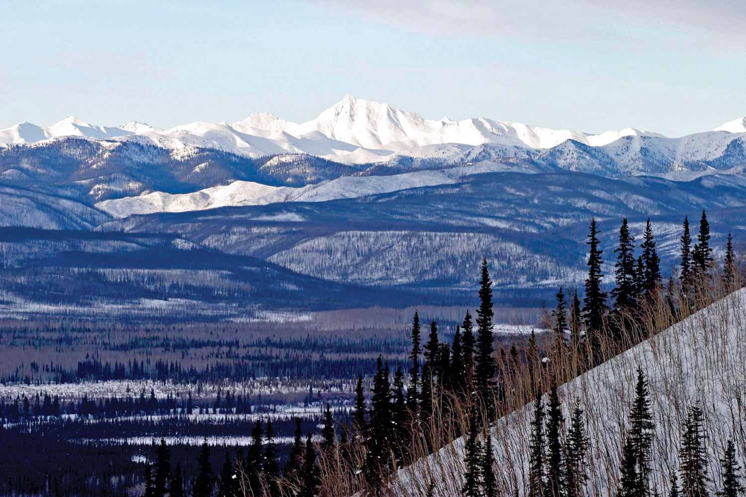
Camping on the Dempster in winter is not an easy task, mostly because people don’t camp on the Dempster in winter. All the campgrounds were closed, and deep snow prevented access to any side trail or rest area. We continued to drive, growing more concerned as the sun began to set, casting a rose-colored glow across the road’s surface, the distant mountains standing in sharp detail against the bent and broken spruce that created a corridor to the north. We scanned the sides of the road looking for a trail, even a pull-out that would provide protection from the building wind and 24-hour truck traffic. Luckily, we found a side road that led into a stand of trees, apparently used by loggers to collect wood for heating the homes in Dawson City.

We pulled back into the trees and shut off the motor. It would be well below zero that night, and we would have to trust that our large battery, synthetic drivetrain fluids, and the Toyota’s toughness would allow it to start in the morning. We deployed the roof tents, climbed inside, and cooked dinner and brewed chai on two stoves perched on a Storm case. Despite the heat from the stoves, we were still wearing our heavy jackets, the condensation from our breath billowing like smoke from our lungs. The cold, dry air was already beginning to take its toll.
The idea of camping at well below zero had sounded like fun in Arizona, but in practice the results were much less glamorous. As soon as the sun set, or with even the lightest breeze, our time spent outside the vehicle or tent was measured in minutes. Being desert dwellers, our skin, our lungs and even our eyes where ill-equipped for the cold, and our heads would retreat inside the sleeping bags to retain every ounce of moisture exhaled.
We awoke well before dawn, and with the HID driving lights puncturing the distance we rolled north. The air was perfectly still, and save for the road we were driving on there was no other sign of man: no buildings, no aircraft, no other vehicles. For hours, we continued north without encountering another soul; we were completely alone. Well, not completely, as the silence and lack of traffic had emboldened the fauna on this desolate piste. Pure white ptarmigans erupted from the side of the road as we passed, completely camouflaged against the snow. A fox crossed directly in front of us, his fur a deep red, and full, and in a moment he had cleared the snow bank and was off into the brush, leaving the three of us scrambling for cameras and feeling more than a bit slow.
Of all the animals this far north, the one I wanted to see the most—even more than a polar bear—was a wolf, to have the chance to lay eyes on one of the planet’s most cunning and accomplished carnivores. My chance would come.
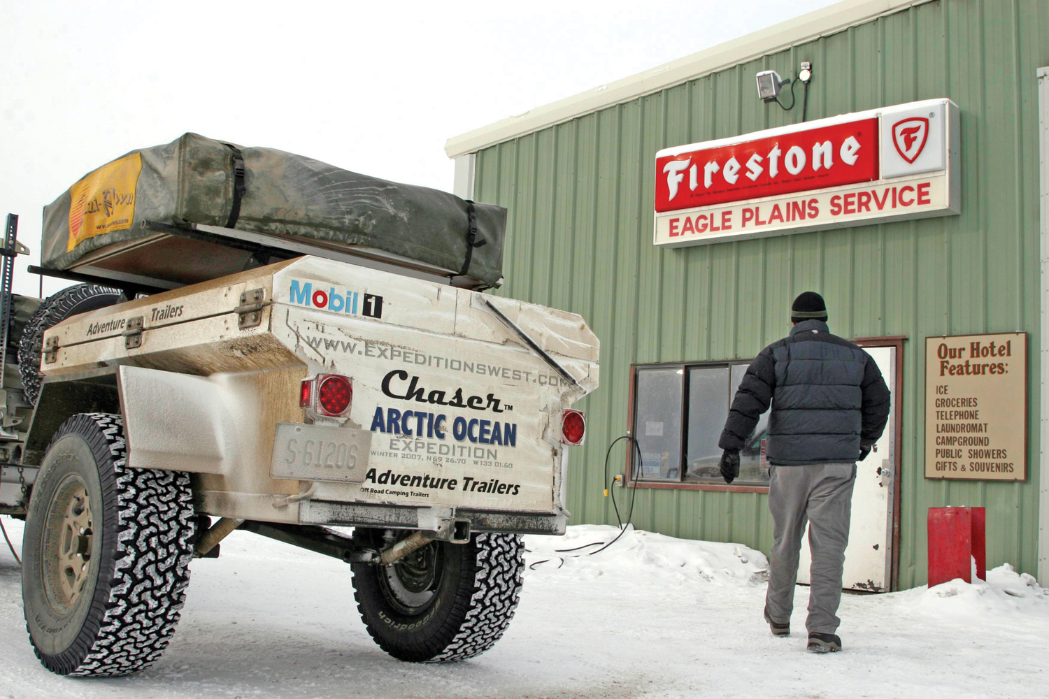
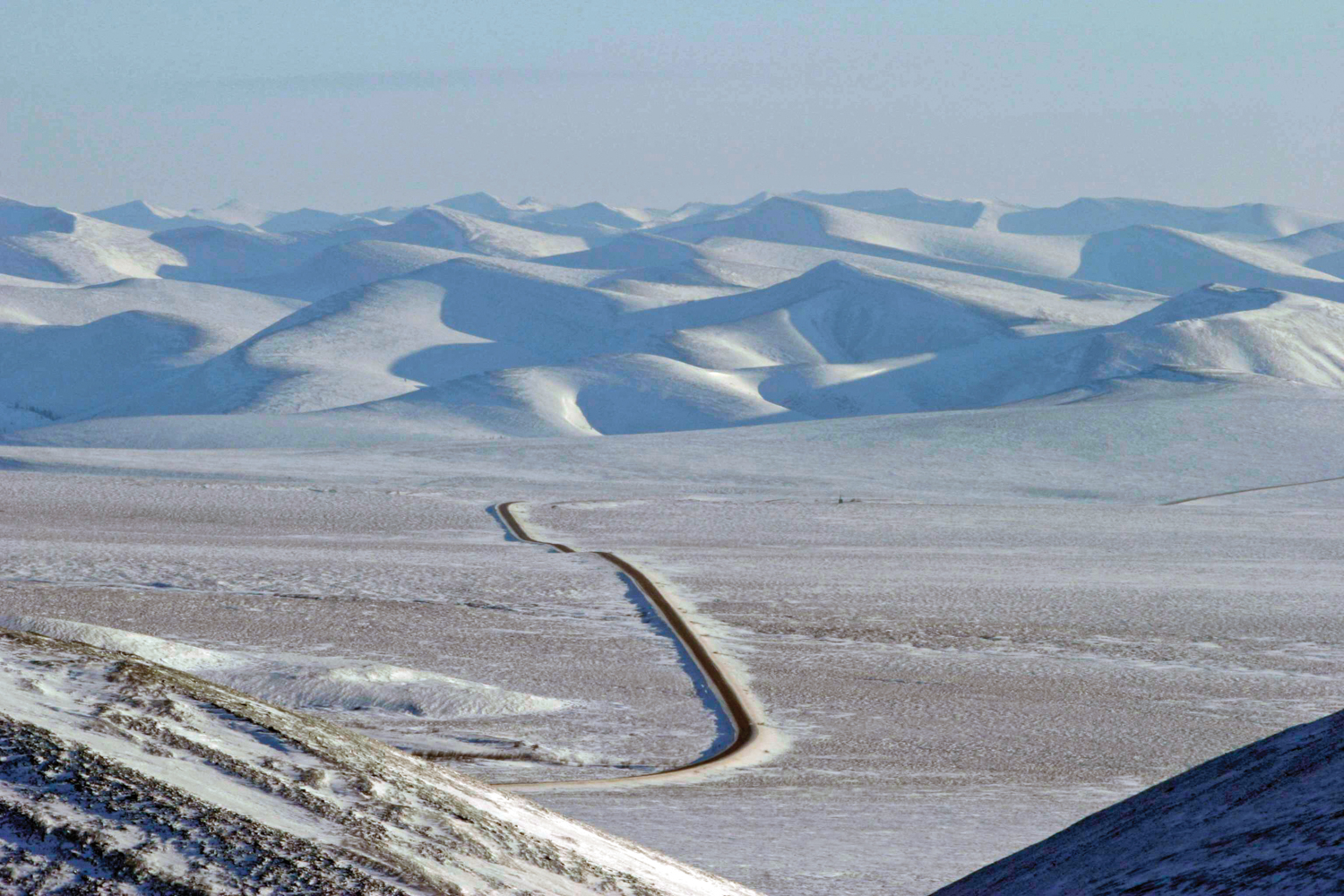
The Dempster can best be described as purity of purpose, a narrow thread of a gravel roadbed built several feet above the permafrost and tundra, and heading as straight as possible to its goal: Inuvik and the rich oil fields above the Arctic Circle. Fortunately, the scenery is nothing less than breathtaking, and every kilometer yields a new vista, a change in flora, or a scurry of fauna. For 735 kilometers, its length is only interrupted once, by the fuel stop at Eagle Plains.
Eagle Plains is also where they often close the road north, because of frequent storms and white-out conditions. Don’t expect a town there, as Eagle Plains is only a small collection of metal buildings, their sole purpose to service passing vehicles. A gas station (run by the lady in the bar), a repair shop, and a motel with cafeteria, all with a heavy 70s feel. The place just felt odd, and not only because the first item for sale on their billboard was “ICE.” The lady in the bar confidentially informed Pasquale that the mountains to the west were not real, only a figment of our imagination. Fearing that another few minutes in Eagle Plains would really have us seeing things, we jumped in the truck and continued north, passing through the open gate with no warning of things to come.

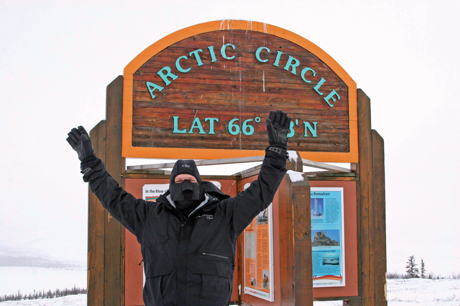
As we would find out later, the gates should have been closed hours before our arrival. The road crew monitoring the winds and white-out just a few hundred kilometers north simply forgot. So our solo white Toyota slipped past Eagle Plains and north to the Arctic Circle, our second major milestone of the trip. The wind was already building, and we pulled masks over our faces and big gloves onto our hands. We could barely see the sign welcoming our arrival at N66° 33’, as the truck rocked from the gusts. I think we spent less than five minutes there, our eyes tearing from the biting wind, no longer able to see through the viewfinder, the howling blasts stealing our words of celebration, our concern building.
The Tacoma wouldn’t move, despite the throttle Chris was applying. The engine revved against an unknown obstacle, then suddenly let loose with a wild crack, truck and trailer lurching forward. Certain something had failed; I jumped from the truck and went to investigate. Had my most trustworthy of vehicles let us down in a rising storm? Crawling around on the frozen surface I saw nothing out of place, and I even double-checked the CV axles, certain they were the culprit. The wind grew more wild and fierce, and sent me retreating to the cab, filling it with blowing snow. “Go ahead and drive again, Chris,” I said, between wiping my running nose and tearing eyes. Again, a violent crack as he pulled away, and with it a revelation: The tires, warm from the previous hours driving, had frozen to the surface. Relieved—at least somewhat—we continued north, deeper into the storm.
We should have stopped, since there were several pullouts along the way, and visibility had dropped to just a few feet, the wind carrying a sheet of white nearly horizontally across our field of view. We had heard rumors of these storms lasting for days and actually turning over trucks. Instead we switched drivers quickly and I continued north, our progress measured 10 feet at a time, the distance between the snow plow poles that lined our side of the road. Inching forward, a pole would come into view and we would move toward it, pass it, and then see nothing for a few moments before the next pole would break the whiteout. For 20 miles this continued as we snaked along the twisting ridgeline that slowly dropped toward Fort McPherson. At last the visibility began to increase, along with it our speed and confidence.
In the distance we saw a parked truck, its yellow lights flashing, clearly waiting for us. A young, smiling Inuit man was sitting in the truck, his cheeks full and lightly frost-nipped. We slowed to a stop alongside and were greeted with a “Hello,” and, “You guys okay?” followed by, “You know, you guys were the last to make it through Eagle Plains before they closed the road, eh?” All we could get in was a “Yeah,” before his eyes lit up and he said, “There are wolves here, just up on the hill, protecting a fresh caribou kill. I watched them take it.” With that, my eyes lit up too, and I was clamoring to get out of the truck with my camera. With emphasis, he added, “There were four of them during the kill. I can only see two now.” Not really a warning against checking them out, but a friendly comment, most likely needed for our survival. We were way down the food chain here, and surrounded by elements and animals that could kill in a moment. The man was patient with us, incredibly kind in sharing information on what he had seen, and pointing to where the wolves were, his eyes trained to the terrain.
And there they were, resting at the top of a ridgeline, their heads, eyes, and ears trained in our direction, but certainly not showing much concern. Actually, more of a taunting look, it seemed to me. Seeing them on the ridge, only a hundred yards away, was a powerful experience. I was humbled to be in their presence.
The road worker followed us the last few miles to the northern gate and let us through and on our way to Inuvik, locking the gate behind. It would remain locked for the next two days. We had been lucky.
Inuvik
Pushing farther north, we arrived in Inuvik a full day early, which allowed us some time to thaw out in a cabin and prepare for the final push to land’s end. We had reservations at the Arctic Chalet, which had several excellent cabins with, incredibly, mostly functional WiFi, and about 30 fluffy malamutes.
With a day to spare, we booked a dog sled ride with Judi and her malamute/husky teams. I have a big soft spot for dogs in general, but especially the Arctic breeds (we own a 132-pound Malamute named Yukon), so going on the dog sled route was pure and absolute fun. My cheeks were hurting more from smiling than the cold, and we laughed, fell over, and got dragged behind the teams for over two hours. What a thrill. There is just something about working with dogs; the activity strikes deep within our nature, supported by 10,000 years of symbiotic partnership with man’s best friend.
Journal Entry, March 25th
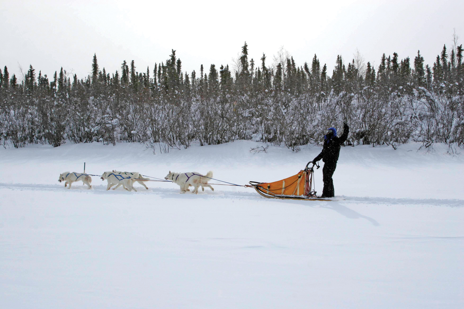
Mush! Well… at least that is what we thought we were supposed to yell. But it turns out that “mush” isn’t really the thing to shout and “go doggies!” works just fine. Give a light press on the braking pad and say “Chee” to turn right and “Chaa” to turn left. Judi Falsnes of Arctic Chalet has some very fine dog sledding teams and they hauled us around this arctic wonderland for the ride of our lives. We were lucky enough to sled with a cross-breed of Alaskan malamute and Siberian husky. They are pure white and I would consider them to be the “Land Cruiser” of sled dogs. They aren’t the fastest, but they will just keep running forever.

Judi and Olav were also a huge help with our planning for the trek farther north, and she called in a favor for us, arranging a day with a polar bear hunter named Joe in Tuktoyaktuk. Things were shaping up nicely, and the next morning we would be within sight of our goal.

The Mackenzie River
We almost failed—well in reality, I almost failed to reach the Arctic Ocean, as the night before our departure I was lying in a pool of sweat, shivering on the bathroom floor of our little cabin. The poison worked swiftly through my body; whatever toxin I had ingested from the food earlier that day was making quick work of me, stealing my strength and clouding my mind. I was shaking so badly that the floor of the cabin began to creak, and with it grew Chris’s and Pasquale’s concern for my safety. They spoke quietly about when to take me to the hospital, despite my urgings to the contrary. I was in violent intestinal distress and had a building fever—and I was the only member of the team with medical training.
I called for Chris to bring me a blanket and pillow, since even though I was sweating profusely I was losing too much body heat, the cold bathroom floor soaking away my strength with each minute, and I could not throw up despite the effort to rid my stomach of the offending bug. Still on the floor, my head in a fog of thoughts, my imagination swimming with the possibility of failure, I slowly faded, slipping into a deep sleep. And my most trusted companions never left my side, checking on me throughout the night.
During the night my body fought back, and I awoke feeling considerably better, although still a little peaked and mentally fogged. Despite this, we knew it was the day to drive north, and we had an appointment with an Inuit hunter, an opportunity not to be missed.
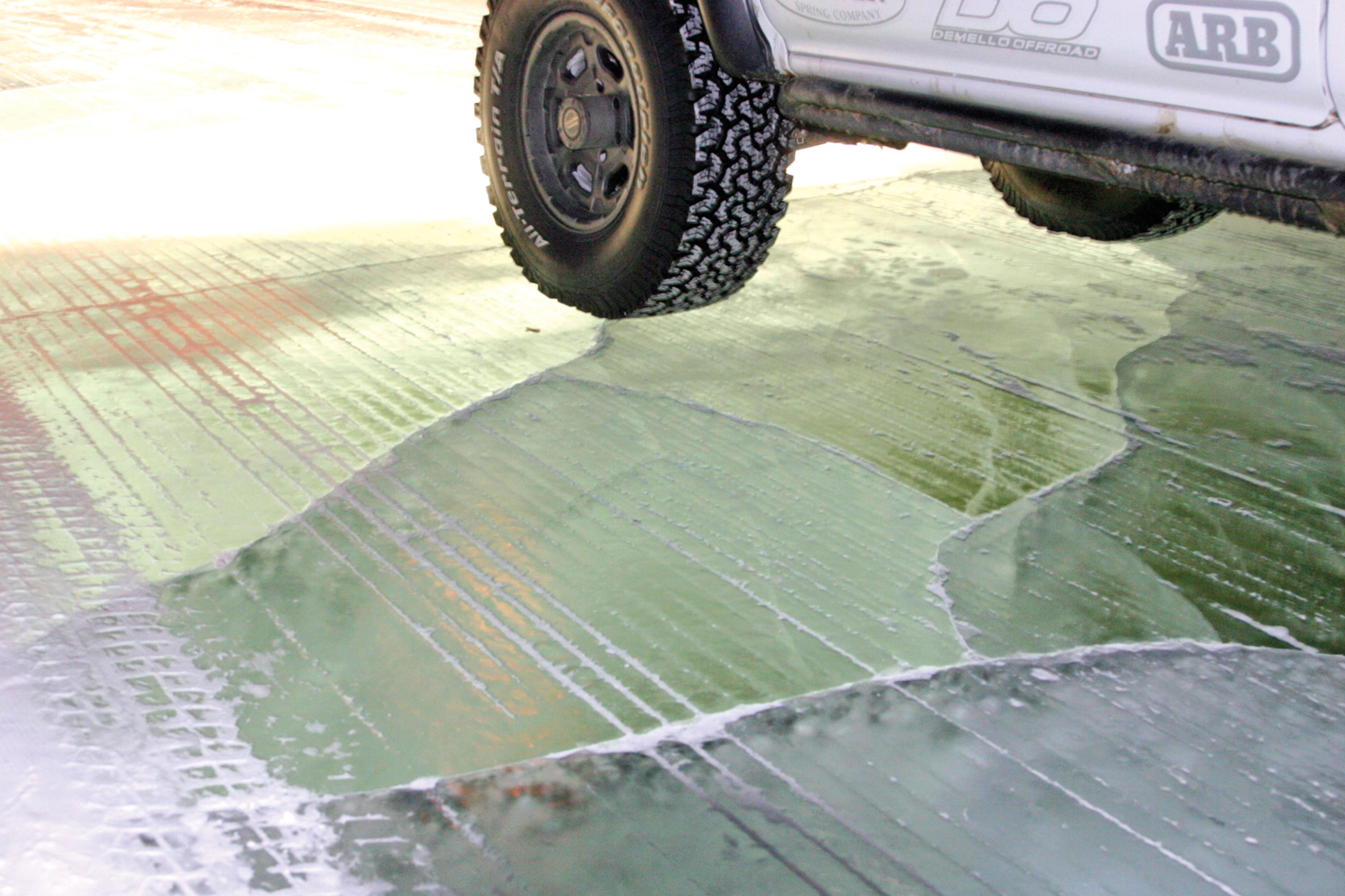
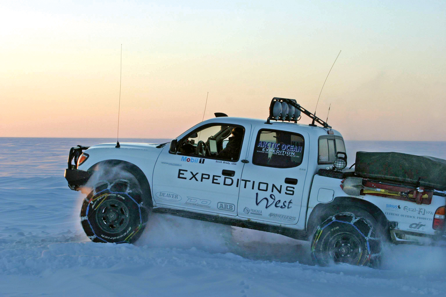
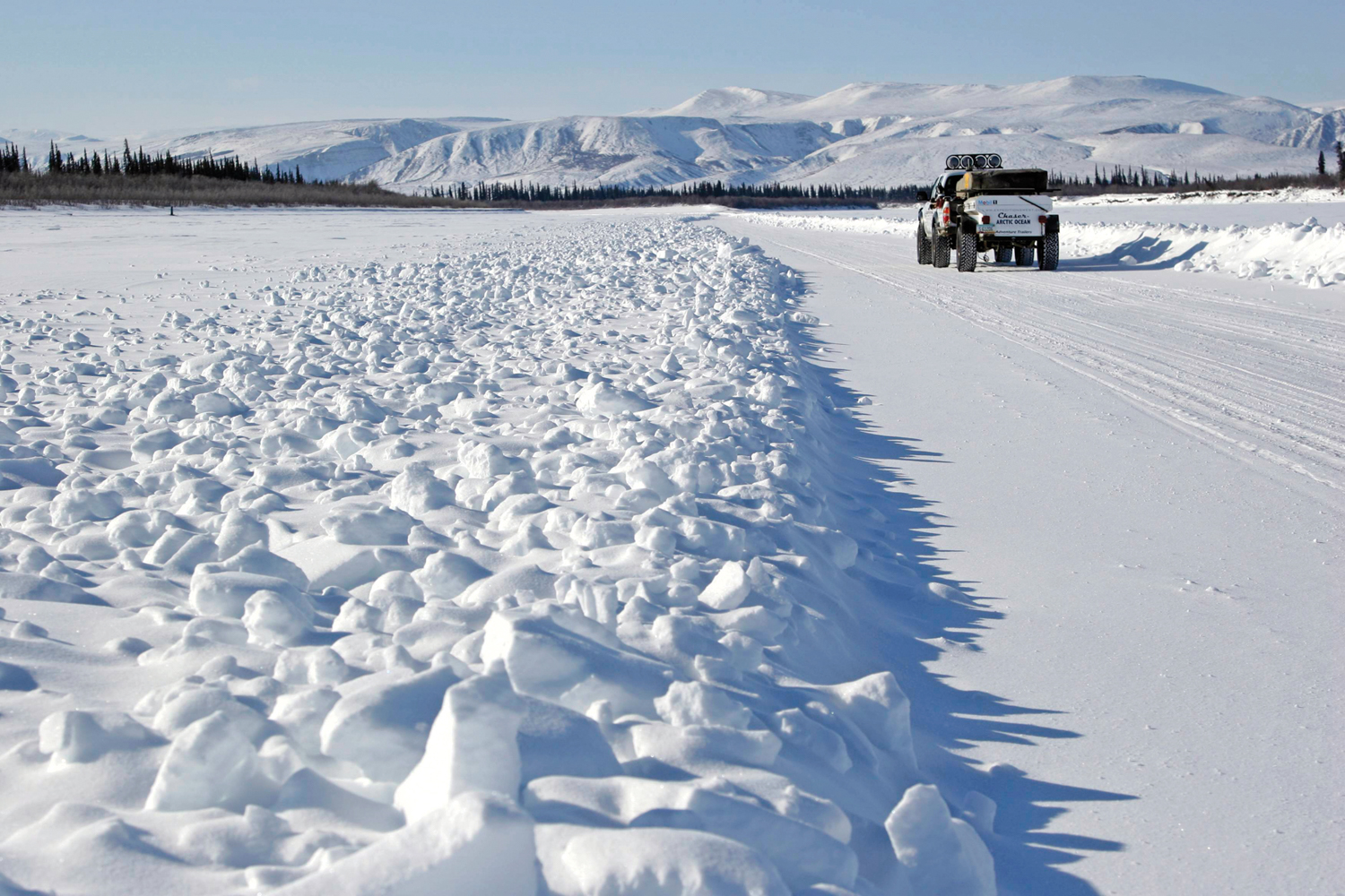
Pulling out onto the ice road—the frozen surface of the Mackenzie River—was a bit anticlimactic. As with most things, the anticipation and imagination of the unknown is much more dramatic than reality. There was even a stop sign at the river’s edge and a road marker indicating maximum weight the ice could carry—over 20 times the weight of our little Toyota. The early spring ice was stable and, most importantly, thick. Driving on the ice road was in fact easier than driving on the Dempster: it was flat, and the turns were wide and easy. Our confidence grew and so did our speed. Land’s end was approaching.
The Mackenzie River begins to split into a wide delta as it nears the Arctic Ocean, and the land loses much of its elevation, becoming nearly flat and difficult to distinguish from the level of the ice. Calling it a river doesn’t quite do the Mackenzie justice, as it is monstrous, the longest river in Canada and when combined with its headstreams the second-longest river in all of North America at 4,241 kilometers (2,635 miles) in length. The delta untethered us from the proximity of land, and all that lay before us was ice, delta, and Arctic Ocean frozen together in an unbroken layer out to the sheer point, the place where polar bears stalk the fractured and broken ice, the point where the sea is too deep and too violent to form a solid layer of ice. We were less than 1,500 miles from the North Pole.
Journal Entry, March 23rd
Despite the lack of clouds, the sky has almost no color, a muted shade of lavender punctuated by the near-stick-like spruce trees, coated in frost, stunted and packed tightly together. It is so dry that my eyes itch and my nose stings when taking a long breath.
Animals seen so far: Lynx, Fox, Wolves, Coyote, Caribou, Moose, Bison, Willow Ptarmigan, Ravens.

Standing on a Frozen Ocean
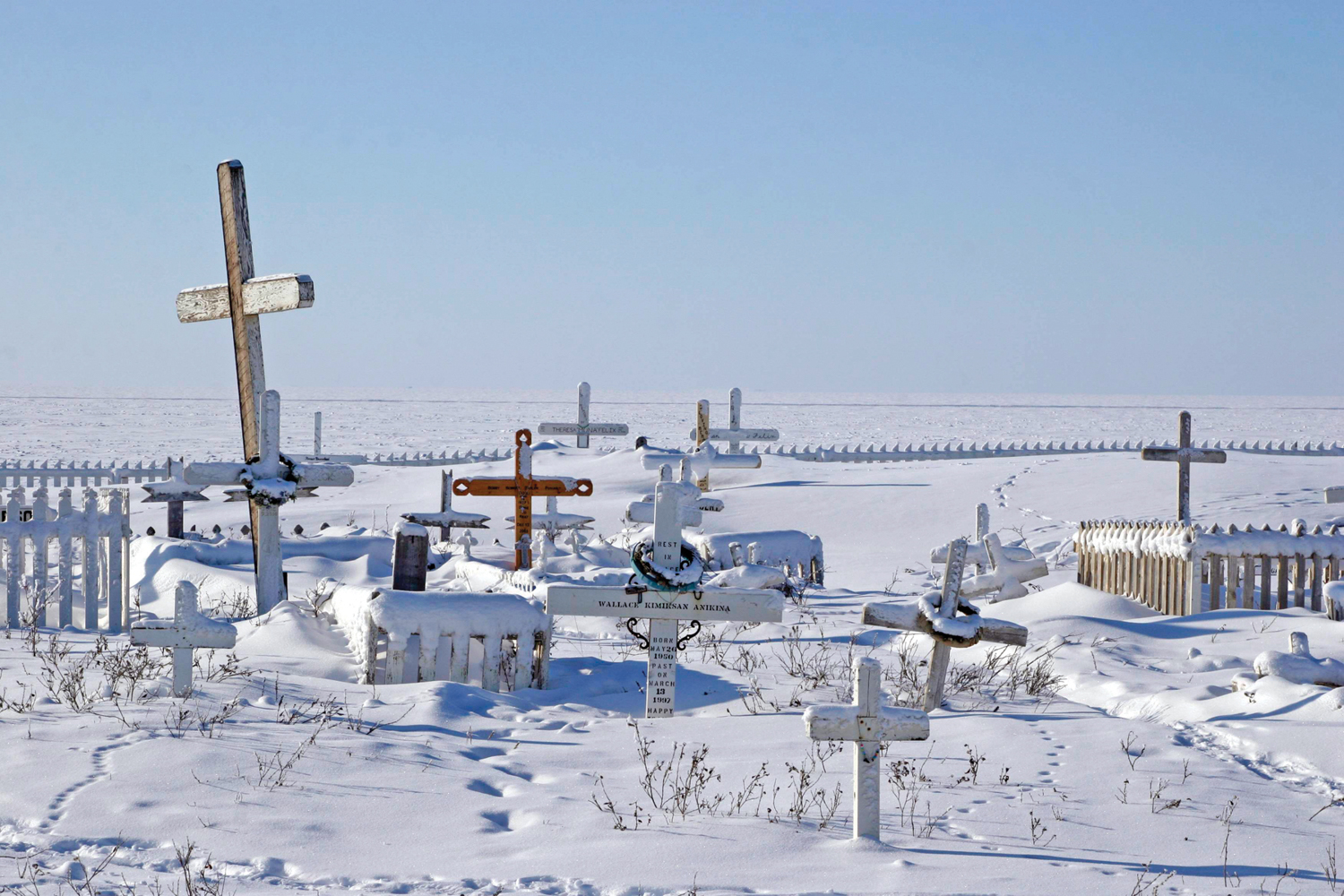
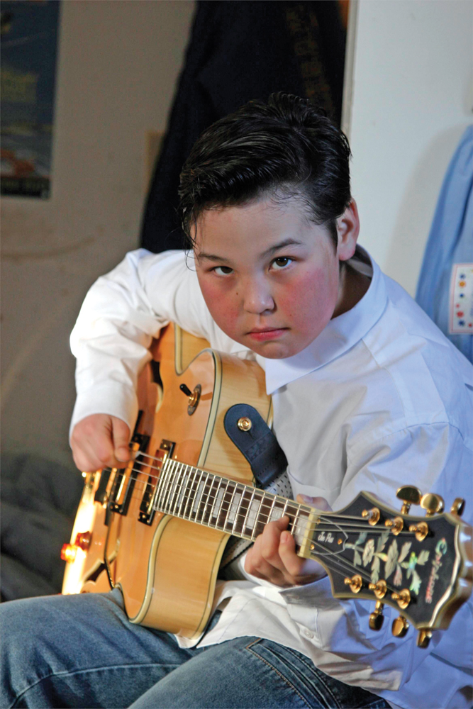
Tuktoyaktuk is filled with history and adventure. People die all the time up here, when a whiteout causes them to get lost, or their snowmobile breaks through the ice, or a polar bear catches them unaware. These are tough people, committed to their heritage, yet more than a bit influenced by those living far to the south. TVs crackle with bad reruns, and the Internet has reached their homes, teaching them as much about who they are and where they came from as anything in their own legends, and exposing them to new concepts of commerce. Joe, our host, spent the first few minutes of our visit enthusing about the antique tea set he had bought off eBay. Meanwhile Joe’s son Larsen strummed Johnny Cash songs on an Epiphone guitar, also from eBay. We were all impressed by this family, who have great commitment to their heritage yet are not afraid to embrace new opportunities or ideas. Larsen was a skillful guitar player, and we could see his dad was proud.
Journal Entry, March 26th
The cold creeps in quickly on the frozen sea, with no land to break the wind’s path, not a tree within a dozen miles for shelter. It is –23°F and the sun is setting against the expanse of frozen ocean beyond our view, the crumpled surface reflecting the sun’s auburn hue across fissures of ice cracked from the pressures of the ebbing sea.
Despite our discomforts, we are humbled by the fact that Joe, our Inuit guide, maintains a hunting igloo 30 miles farther into the Arctic Ocean, where he insulates himself with twin caribou hides laid skin to skin and covered with a 4X down blanket. We spent the day in Tuktoyaktuk with Joe and his family, sharing in their stories, myths, and a meal, the silence broken by their son Larsen playing Folsom Prison Blues with his hair greased back and wearing a white button-down shirt.
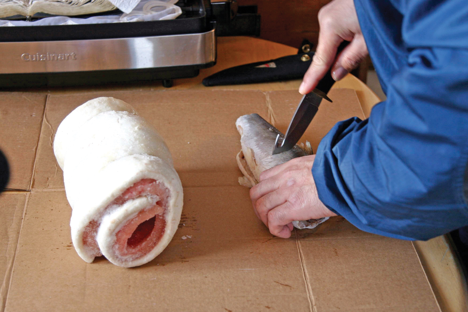
Joe left the table for a moment, and returned with a few heavy packages wrapped in newspaper. He slid the contents of the packages onto a piece of cardboard: a few fish and a huge chunk of red and white flesh, rolled into a log. If supplies or money run short for a family, this is what they eat, the menu of their ancestors, caught and prepared in essentially the same way. The fish was herring, caught in big nets and then smoked over a fire and frozen. Joe cut off several small chunks for us, salting them heavily to help mask the intense flavor. My stomach still reeling from the night before, I took a small bite. Next was the muktuk, an Inupiaq word for raw whale flesh and blubber. Joe cut small slivers of the creamy white fat for us to try. It was chewy and nearly tasteless.
While we sampled, Joe gorged, as if the traditional sources of protein before him had struck a deep, primal chord. He used a big knife to cut mouthfuls of meat, pouring on the salt and stuffing them into his mouth. He stopped talking altogether and finished off the herring before coming back to his more modern self. Looking a bit conscious of the amount of food he had just eaten, he said, “I have eaten enough fat in my life that would have killed five white men.” No doubt he had. With that, he was up, and moved outside to show us his polar bear mitts, skins, and hunting equipment. He was planning a traditional hunt, with only dogs and spears. He wants to tilt the odds back toward the bear.

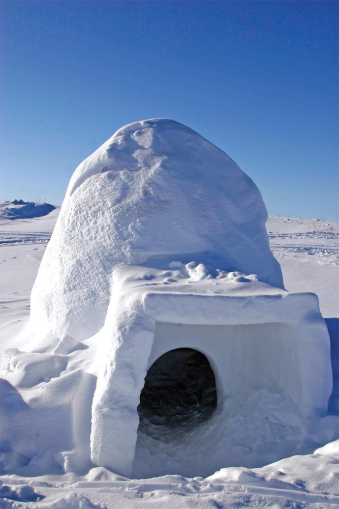
As the day came to a close, we took a tour of the community ice house, a food storage tunnel dug 40 feet below the surface, deep in the permafrost, used to store emergency staples, and food for dogs. At the top of the entrance shaft, Joe tied a tattered hemp rope around my waist; the rope must have been as old as the tunnels, dug a half-century before. He called it their “Eskimo climbing rope,” and the frayed ends and multiple knots provided no sense of security for the climb down the ancient ladder. It creaked with each step, and my shoes slid about on rungs coated with a veneer of frozen blood and fat. Soon, Chris and I were at the bottom, no worse for wear and walking about with the aid of our headlamps. Small, crooked doors concealed the contents beyond the narrow corridors. My head bumped the ceiling and my shoulders rubbed the walls, the permafrost twisting in shapes and colors. It was like walking through the center of a huge bowl of rocky road ice cream. The walls had been frozen through since the last ice age. It must have taken immense effort to create this life-saving storage.

After the ice house, we spent a few more minutes talking with Joe, asking him a few questions about his life in the Arctic. One comment was of note. I asked Joe if he had seen any effects of global warming. He smirked a bit, and said, “You mean, other than all the scientists that started coming up here?” Then, “Well, I am looking forward to global warming. Have you seen where we live? The thought of it getting warmer up here sounds pretty good to me.” Certainly a different and understandable perspective.
Aklavik and the Peel River
After visiting Tuk, and spending nearly an hour watching the sun set across the Arctic Ocean, we returned south for one more night at the Arctic Chalet in Inuvik. With our return visit came good fortune in the form of an email . . . from the resident of the cabin next to ours. Marcel had looked up the Expeditions West website and found my email address, and sent us a note.
“Hey!
I’m in the other side of the cabin at Arctic Chalet. I assume you’ll be going to Tuk, but I wanted to suggest another ‘road less traveled’ once you take care of that. The ice road to Tuk branches off a bit north of Inuvik, the branch leading to Aklavik (which means Grizzly Bear Place). Past Aklavik there is a new road north by northwest leading to a gravel source in the Richardson Mountains. I discovered it on a drive to Aklavik a month ago, but ran out of time, so couldn’t drive it. Just thought I’d let you know. Most people around here don’t even know yet that it exists! Also, I heard recently that there has been an ice road from Aklavik to Ft. MacPherson, so you won’t have to backtrack so much.
Marcel (next door)”
Our schedule allowed for an extra day as safety margin, and now we had been granted an opportunity for some very remote exploration. We quickly packed up the truck and drove back out onto the ice road, but this time our first objective was Aklavik, which is accessed from a narrow ice route that splits from the main Mackenzie ice road and turns west.
The town of Aklavik is a gem, and sees little tourism—which is unfortunate, as the people who live there are considerably more friendly toward travelers than the main stops. They also had a new store with readily available fuel and food, including fresh (if understandably expensive) vegetables. Two of the locals took particular interest in us, and regaled us with the history of their town, the legend of the famous “Mad Trapper,” and the ice performance of their big Ford diesel. After we declined their invitation for an ice drag race, they wished us well with big smiles and firm handshakes.
To drive the Peel River was a rare opportunity, as this route is not maintained by the government and its condition is only confirmed through local knowledge. The 120-mile, twisting, narrow, and remote river is cleared to the width of one vehicle every few years, in support of the big native festivals held in the area. It allows for a much shorter route from Fort McPherson to Aklavik, and we would be among the first outside visitors to drive its length and document its challenges.
The narrow Peel was significantly different than the Mackenzie. The snow had collected in deep bands across the cleared route, and in several locations the ice had shifted and fractured, leaving a tall shelf to climb. It was perfect, and for over 100 miles we did not encounter another vehicle, not even a tire track, as we wound our way south. Absolute silence and the sense of remoteness reigned as the three overlanders from Arizona proceeded over-water to a distant goal. We were completely dependent on our truck; it was our only lifeline.
The Aurora
Our arrival in Fort MacPherson signaled the end of the ice roads, and in our minds the end of the adventure. From that point, we would only have the long trek back south, retracing over 4,000 miles of winter road conditions to home. However, the Arctic still held a surprise.
As we headed south on the Dempster, my only regret was that we had not seen the Aurora Borealis. It was late, and the cab was quiet, the silence lightly broken by whatever music played from the iPod. I was driving, and just inside my peripheral vision I caught a glimpse of green. I slowed down and looked over my shoulder to the north—and stared, my eyes transfixed on the most amazing display of light and color I have ever witnessed. It was like the combination of 20 years of grand finales dancing across the horizon. It was the Aurora, and we came to a stop in the middle of the road and stepped out of the truck to watch in silent wonder. The Arctic had bid us the most magnificent of farewells.

TRIP PLANNING
Whitehorse to the Arctic Ocean, northern Canada
Requirements
The Arctic is a volatile region. Travelers can expect intense temperature variations, white-out conditions, frequently closed roads, and poor infrastructure. Obtaining spare parts and having them installed can take days or weeks. Repairs in the field can be deadly. So, as a traveler, proper preparation of the vehicle and team can mean the difference between enjoying the Northern Lights and coming home minus a few toes.
Vehicle Preparation
Proper vehicle choice, preparation, and inspection is absolutely essential to a successful Arctic trip, especial as a solo vehicle. Accounts of other trips to this region are littered with dead batteries, cooling system failures, doors frozen shut, and seized engines. Here is our top ten “must-do” list for a long-distance Arctic adventure.
1. Reliability: Vehicle reliability is vital, so proper service is paramount. Start with a high-quality vehicle, designed for operation in harsh climates and over long distances of rough roads. Research the cold-weather testing performed by the manufacturer of your vehicle. All Toyota trucks are tested to –60°F; other manufacturers typically employ much less stringent standards.
2. Batteries: Install two, large-capacity batteries and keep them isolated when the motor is not running. We installed a group-31 and group-24 AGM Lifeline battery in the truck with a heavy-duty relay. Even at –40°F, the truck always started immediately, and we had a spare that could jump or assist the main if needed.
3. Low-glass-rated tires: Make sure that the tires fitted to the vehicle have a glass rating (the point at which rubber becomes a solid and can fracture) below your predicted operating range. The BF Goodrich All-Terrains we had fitted are good to at least –60°F. Use an all-terrain tread design with siping for good performance on ice and wet roads.
4. Fluids: Use 0W30-grade synthetic engine oil, and lighter synthetic gear grades as well. We used a Wolverine 50-watt oil pan heater to run off 12V and a 250-watt unit for shore power. The transmission was fitted with a 125-watt unit. www.wolverineheater.com
5. Lighting: Winter brings long nights, and for periods in December and January the Arctic is cast into nearly complete darkness. We used IPF HID lighting to extend driving hours and ensure sufficient visible distance to eliminate animal strikes. We combined two HID lights on the bumper with four halogen spot beams on the roof.
6. Chains: In winter, a trip to the Arctic from the continental U.S. will require thousands of miles of road driving. Many areas require chains to negotiate mountain grades, and it is a good idea to have them regardless. Quick installation is also critical at sub-zero temperatures. We used the new Thule tire chains for fast set-up and good traction performance on ice and snow. konig.it
7. In-cab air temperature: Keep the truck cabin cool, to prevent large swings in temperatures as you enter and exit the vehicle. This also helps reduce condensation on camera lenses. Overall, it is safer and more efficient to wear extra layers while driving, just in case a quick exit is required.
8. Water temperature gauge: The gauge provided by the vehicle manufacturer is not sufficient to monitor coolant temperature. In the Arctic, it is essential to ensure that the engine gets warm enough to promote efficient combustion and proper operation. We used a Scan Gauge II to monitor the engine and transmission status. scangauge.com (OBDII vehicles only)
9. Spare parts: Talk with other owners of your model vehicle and determine the parts most likely to fail at your mileage (plus 20 percent) and either replace the components or carry spares. A spare alternator, all belts and hoses, fuel filter, critical fuses and relays, and known failure components should comprise a minimum spares kit. Know how to change them all in the field using the tools you carry in the vehicle. At –20°F, there is little time for troubleshooting. Consider bringing a tent heater and tarp to make a temporary work-space shelter.
10. Code reader: For OBDI and II vehicles, a code reader can be a trip saver. In Whitehorse my truck displayed a check engine light, which proved to be nothing but a loose gas cap. Being able to diagnose issues quickly and bring in the right parts is a real time saver. www.scangauge.com
Personal Equipment
As three guys from the Southwest, we learned a lot about personal equipment, and some of it the hard way. The expensive North Face equipment did not work as advertised, but the less expensive Columbia Titanium gear exceeded our expectations. This was particularly true of the manufacturers’ comfort rating. Our –20°F-rated North Face boots left our toes frozen at –10°, while Pasquale stayed comfortable in the same conditions in a pair of identically rated Columbia boots (and he was even more stationary). Here is what worked:
1. Layers: You’ve heard it before, but layering is essential. We used Minus 33 brand wool base layers and then a series of Columbia layers, including fleece and wool. Avoid cotton.
2. Protecting your skin: Products such as Mustela with beeswax work well. The dry conditions require constant evaluation of skin and eye condition. Those with contacts will suffer the most.
3. Protecting your lungs: I did not use a balaclava for most of the trip, and my lungs suffered severely as a result. It took several weeks before I could take a full breath pain-free. Use a balaclava to rebreathe warm, moist air.
4. Survival bag: Prepare for the worst event (like the vehicle falling through the ice) with a bug-out bag filled with survival essentials, including a personal locator beacon (PLB), dry clothes, emergency water, food, shelter, and a compact down sleeping bag. Each of us had a bag handy in the cab.
5. Good boots: One of the products that failed to perform was our expensive boots. Research the performance of the brands you are interested in, beyond the manufacturers’ claims. We found that different boots with the same rating performed differently. I also recommend a good pair of down-filled booties, which will make a big difference for sleeping. We used 700-down-filled booties with rubber soles for camping.
6. Quality sleeping bag and liner: One of our two Alps Mountaineering –20°F bags split out a zipper, and both Chris and Pasquale experienced severe cold spots. I had better success with my traditional Coleman canvas –0°F bag and a 15° fleece liner. If specifying for this trip again, we would use bags with much lower ratings and higher-quality construction.
7. Organization: Keep the cab and storage areas organized and easy to access. At these distances and temperatures, efficiency is key to morale and comfort.
8. Canon cameras: For four weeks, 4,000 images, and 28 hours of HDV footage, we had no failures in the camera equipment. Chris and I used Canon 20D prosumer bodies with Canon L lenses (24-105mm and 70-200mm). Pasquale used XLH1 and XHG1 high-definition video cameras with PortaBrace covers.
9. Good food and liquids: Stick with high-quality foods and lots of warm liquids (avoid restaurants). We used a Jetboil (see stove test, this issue) to simplify preparing tea and coffee. Healthy snacks kept the drivers nourished and prevented big swings in blood sugar.
10. Good tent: We used Eezi-Awn roof tents for the entire trip, and although they were not designed for Arctic conditions, they never failed us, and always provided a comfortable place to sleep. The canvas walls also fractionally improved insulation, along with the standard thick mattresses.
Seasons
Driving to Tuktoyaktuk can only be done while the ice roads are open, which means late winter to early spring. Ice is usually at its thickest and most stable in early spring (March timeframe). Expect temperatures to be as low as –60°F and as high as +15°F along the Dempster and Mackenzie routes. Summer is typically beautiful in that area, yet still cool. Overall, precipitation above the Arctic Circle is minimal, and restricted to late summer months.
Waypoints/Route
Braeburn Lodge (Klondike Hwy Mile 55)
Approximate coordinates: N61° 28’ 51.74”, W135° 46’ 44.07”
Famous for their enormous cinnamon buns, and also a stop on the Yukon Quest dog sled race, Braeburn Lodge is a welcome sight for hungry travelers.
Klondike River Lodge (Dempster Hwy Mile 0)
At the intersection of the Klondike and Dempster highways (Mile 301 of the Klondike), this is the sub-Arctic equivalent of a desert oasis for the Whitehorse-to-Inuvik traveler. For fuel, food, and water this is a priority stop. From here, it is 456 miles to Inuvik.
Eagle Plains
(Dempster Hwy Mile 229, population: 8)
There is a hotel, restaurant and phone (867-993-2453) as well as a tire repair shop and fuel station. Diesel fuel and propane available. Electrical hook-ups, dump station and camping (check ahead of time depending on season). This is where the road is often closed to north-bound traffic due to common weather issues (including white-outs in our case).
Fort McPherson
(Dempster Hwy Mile 342, population: 952)
Small town with a few services, located where the Dempster Highway crosses the Peel River (ice bridge or ferry crossing). Dene Indian crafts, artwork, and guide services may be available depending on the hours and season. Home of the famous Fort MacPherson Tent & Canvas Company.
Mackenzie River Crossing
(Dempster Hwy Mile 378)
Ice bridge or ferry crossing depending on season. Townsite of Tsiigehtchic, a small Gwichya Gwich’in community is located here. Location of the confluence of the Mackenzie and Arctic Red Rivers.
Inuvik
(Dempster Hwy Mile 456, population: 3,667)
Small town located on the banks of the Mackenzie River. This is a hub of activity in the region and has all major services including food, fuel and lodging year-round. This is as far north as you can drive, except in the winter season when the frozen river becomes certified for vehicular use. Visit the Arctic Chalet for comfortable accommodations year-round. Be sure to inquire about their dog-sledding adventures. arcticchalet.com
Tuktoyaktuk, or “Tuk”
(93 miles north of Inuvik, population: 943)
Approximate coordinates: N69° 26’ 34.00”, W133° 01’ 52.00”
A small Inuvialuit community on the shores of the Arctic Ocean. Approach by vehicle must be made during the winter, driving on ice beginning on the Mackenzie River at Inuvik, to one of the largest river deltas in north America, ending with a drive along the surface of the Arctic Ocean close to the shoreline. Tuk is famous for its pingos, large hills of frozen ground being forced upward by subterranean water pressure, some of which are around 1,000 years old.
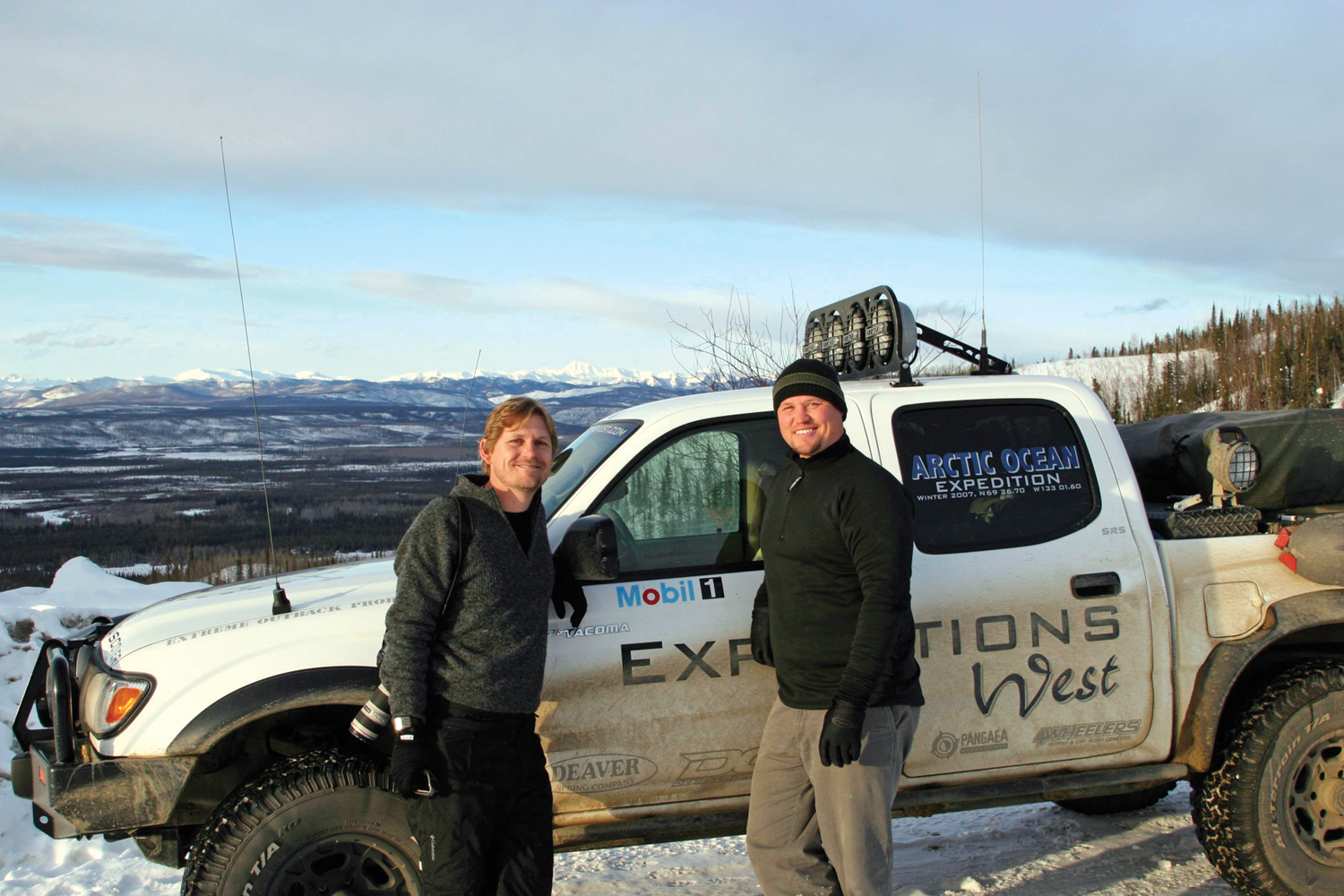
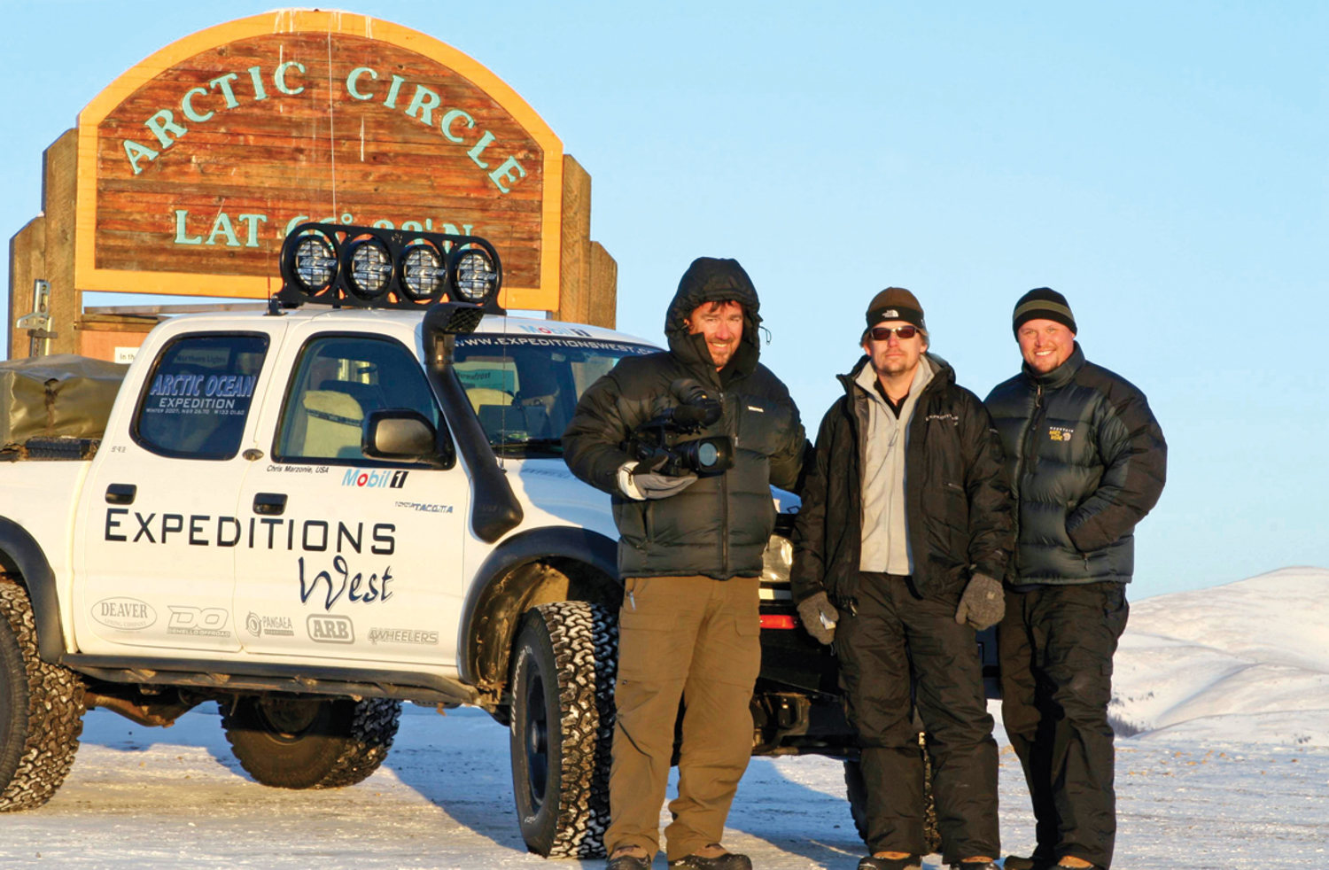
Chris and Pasquale were wonderful travel companions and exceptional adventurers
Resources and Special Thanks
Kanoe People: A wealth of local knowledge and support in Whitehorse. Personal locator beacons available for rent. www.kanoepeople.com
Arctic Chalet: Dog sledding and WiFi, along with clean, comfortable cabins. www.arcticchalet.com
Gun Barrel Steak and Game House: Buffalo Prime Rib. www.gunbarrel.com
American Expedition Vehicles: Custom expedition vehicles prepared by overland enthusiasts in Missoula, MT. www.aev-conversions.com
Adventure Trailers: For providing Chaser #1, which made a solo vehicle expedition possible. adventuretrailers.com
Thór Jónsson of Viking Offroad: Thór also was a key supporter of our expedition, providing detailed logistics support on Arctic travel. www.vikingoffroad.com
A big thanks to all those who helped along the way, including Jeff McLaird, Matt Svoboda (from Jeep), Steve in Calgary, Peter Hartl and Jim in Whitehorse. Without your hospitality and support, this trip would have been much less enjoyable.
And our Arctic sponsors: Mobil1, Adventure Trailers, American Racing Wheels, ARB USA, BF Goodrich Tires, Deaver Springs, Donahoe Racing, EarthRoamer, Equipt Expedition Outfitters (Eezi-Awn), Extreme Outback Products, Sirius Radio, Thule, and Viking Off-Road.
Story originally published in Overland Journal
by Scott Brady
4 Comments
Pingback:
March 24th, 2018 at 5:40 pmRyan Ward
August 21st, 2018 at 12:25 pmI just pulled up this article to re-read it, it’s still one of my favorite OJ articles of all time. Sadly I noticed that the pictures are no longer working. Any chance someone could update the links so the original story is still intact with photos?
Christian Pelletier
August 23rd, 2018 at 7:06 amRyan – I just checked and the pictures appear to be all there. Can you try again?
Pingback:
January 28th, 2020 at 12:05 am