

Story by Jack Stuhler with an introduction by Paul May.
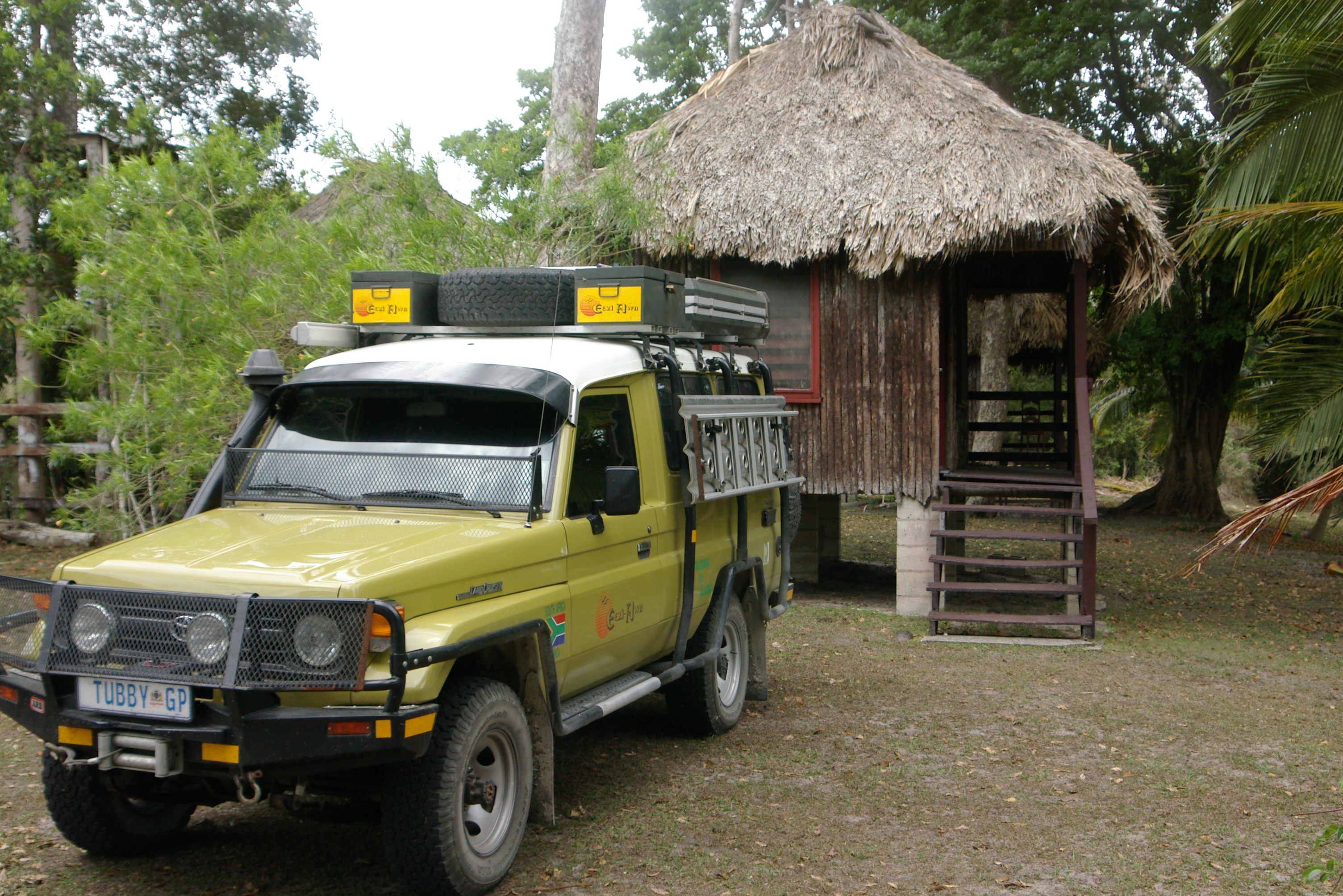
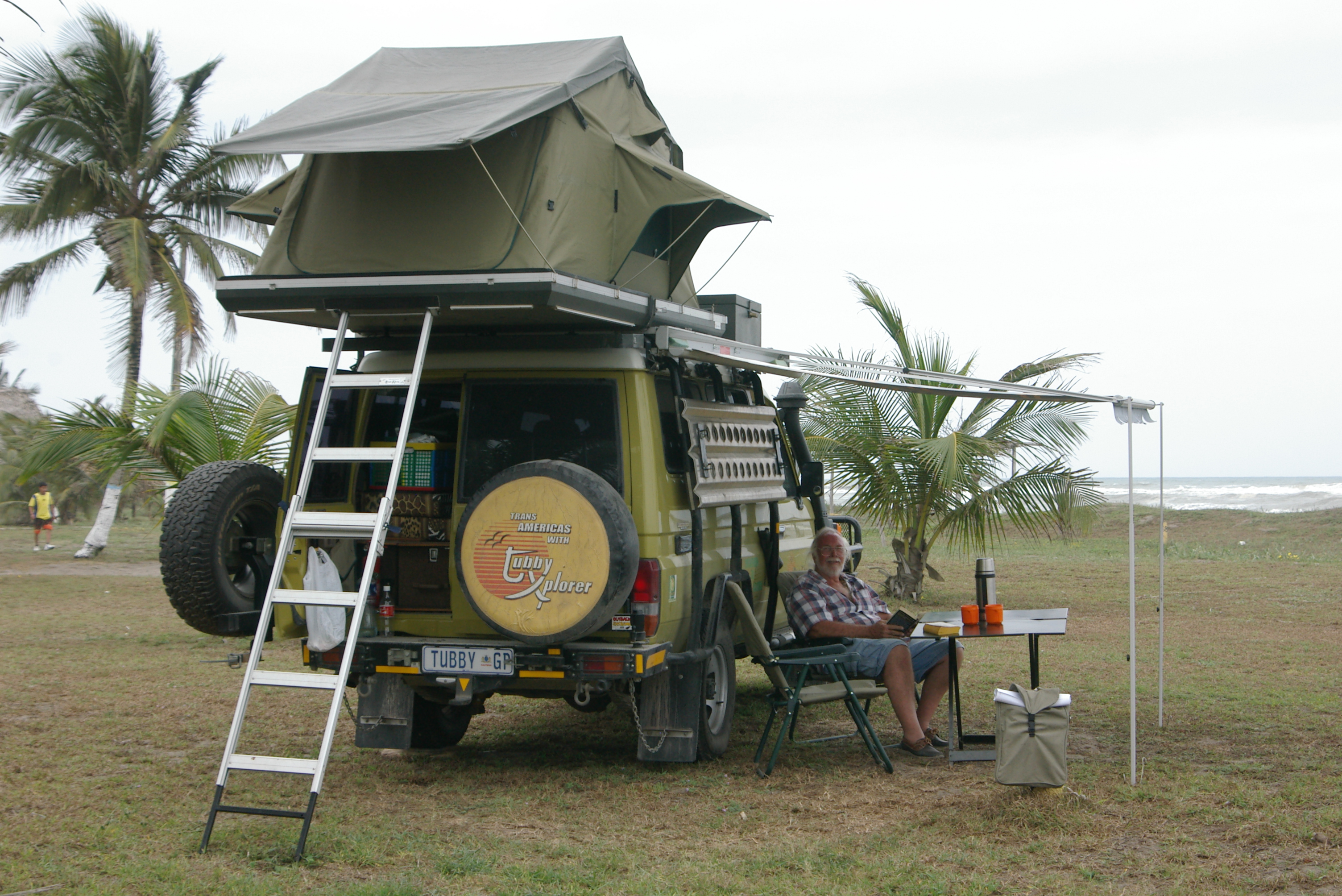
Jack Stuhler, the founder of Eezi-Awn, is an adventurous man and has spent his entire life exploring the African Continent. After driving from Johannesburg to the UK through the middle east in the early 1999, Jack set his sights on the Americas. He prepared a Toyota Land Cruiser 70 Series Troopy by the name of Tubby for his journey and shipped it to South America. With his significant other, Margaret, their epic journey from Ushuaia to Dead Horse Alaska took over 18 months to complete in 2004/2005. They later returned south to Houston, and shipped Tubby home. Quite impressive for a couple in their 60s. Their adventures are an inspiration for us all. www.equipt1.com
“Mum” was the word as Margaret and I left Tikal in the Landcruiser and drove south back to Ixlu then set off east towards the border and Belize. Only when we reached the crossing did I inform her that we had just travelled one of the most dangerous roads in Guatemala known for highway robbery, tourists being the prime targets. In my mind it is sometimes better to keep stumm as to the possibility that something untoward may occur lest you upset or cause anxiety for your travelling companion. Not necessary!!!! Keeping one’s mouth shut is the best!!!
Safe and sound we continued our journey into Belize, formerly British Honduras, a sparsely populated tiny country with a population at the last count of 275,000 but most rewarding was that ‘Ye English is spoken’ alongside Spanish and a fascinating unique dialect of English which is not easily intelligible to an English speaker. Then of course 10% of the population are still of Mayan descent with their own language.
 Crossing through mountainous countryside and ever so often with evidence of slash and burn subsistence farming we wandered further into Belize, near Balmopan the capital we veered off south on the Hummingbird Highway to Dangriga on the Caribbean coastline wound up in ‘Ruthies’ Cabanas’ on the northern foreshore of the small town, total inhabitants 8,000 people. Balmopan, the new Government seat, was constructed upcountry to avoid the severe hurricanes that continuously batter and flatten the former capital, Belize City, thereby disrupting governance. In spite of moving the capital most Government employees refuse to live in Balmopan and continue to commute back and forth from the coastal city.
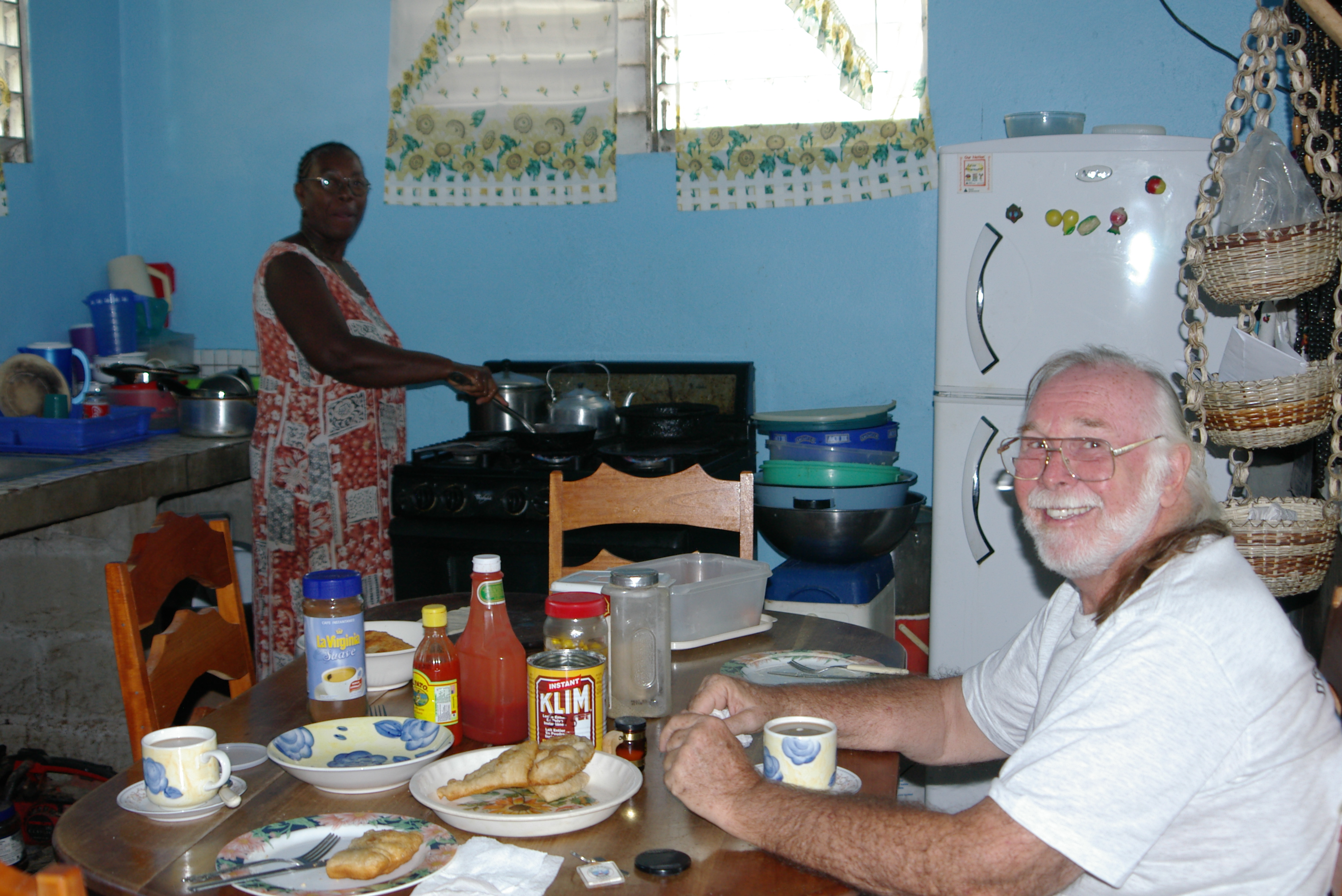
Our digs, a crudely thrown together rustic cabin, constructed of timber with a palm frond roof, standing on stilts amongst tall coconut palms, situated on the beach not more than 30m from the rolling waves of the Caribbean Ocean. One would think “What an idyllic setting” but looking beyond the yard most of the houses of the area were rickety and in disrepair – sheer poverty all around.
Ruthie, quite a character whose parents originally came from Trinidad, a jovial person, a marvellous cook. But oh!oh!, the kitchen, utensils and stove well worn, leave much to be desired, the food though prepared in traditional Garifuna (Black Caribbean) fare absolutely tasty. In spite of the run down surroundings our stopover was most pleasant however the road was beckoning – to roll on and on.

Drifting through Belize one soon realises how poor the country is. Most structures e.g. sugar mills left behind by the British when they pulled out are in a state of disrepair. The timber and palm frond roofs falling apart; where corrugated metal has been used for walling or roofing rusting to decay. The folk seem to have no pride in their surroundings. We have never seen so much scrap lying around, derelict buses, trucks, cars and even on a large dilapidated farm, huge harvesters and combines – such a sin to see all this go to wreck and ruin.
Leaving Dangriga and the Caribbean coast behind we ventured back up the Hummingbird Highway to the crossroads at Balmopan and then headed north up the Northern Highway bypassing Belize City calling in at ‘The Community Baboon Sanctuary’. The locals call the black howler monkeys, baboons, and in this particular area a number of them have been habituated to accept humans at close quarters albeit living in the wild. Our guide, one of the locals, led the way into the jungle and it was not long before we found a family of eight primates consisting of a dominant male, a female with a youngster of approximately ten days old, and some juveniles. Apparently a family of howler monkeys consists of an average of eight to ten animals. At least this community are conserving their wild life. From a mere 800 animals twenty years ago there are now an amazing 3,500 howlers
Each day is an adventure as we travelled into new unexplored territory, this time a 35 kilometre trip up the New River to the Mayan Ruins at Lamanai. En route to the ferry for embarkation I noticed that the Cruiser’s head, hazard and indicator lights were inoperative. I decided to let sleeping dogs lie and that I would attend to it when we had returned from our trip up the river.
Once on the boat with our guide and fellow tourists (ten in all) we slowly sailed upstream, dense jungle both sides of the river to observe wildlife. Saw a large black tailed snake on a thick branch overhanging the river consuming a smaller boa (python), bats clinging to a burnt out log and many birds along the way. Two hours later we reached Lamanai that means ‘submerged crocodile’. The ruins were not as majestic as Tikal or Copan but one of the most outstanding features was the huge, well-preserved, 4m tall face at the Temple of the Masks. The earliest buildings were erected as far back as 700 BC, culminating in the tallest pre-classic Maya structure the 37m major temple of about 100 BC, and has the longest history of continued occupation only to be deserted at the time of the Spanish in 1580 and thereafter British occupation. It was mid afternoon when we returned to moorings at the base of the toll bridge leading to the village of Orange Walk. We pulled out of there by-passing the latter and late afternoon rolled into Corozal.
By nightfall I had checked all fuses, stripped Tubby’s dashboard, removed the steering wheel etc. etc. to check all connections but to no avail. At first light I was up and back to the vehicle, re-assembled most of the dash and took off to a local ‘Sparky’ (motor electrician). Whilst explaining my predicament to him I noticed that the positive battery connection, which I had undone numerous times the previous afternoon had a electrical connector with no lead attached. Without further ado, he replaced the electrical wire and I was out of there as happy as a pig in strawberries!! “Couldn’t drive over here without head, hazard nor indicator lights could I??”

By 10.00am we pointed the Toyota Troopie on its way to the border and Mexico our last destination in Central America. You may get the impression we were flying through this part of our journey but Margaret and I could be picky, picky (selective) now and explore the best of the best as we had done in our travels in South and Central America.
We were about to leave Belize, the people extremely friendly, the countryside in many places majestic – the country in a mess. The most expensive yet poor country we had visited to date. A future too bleak to imagine. Since the British left it seems to be only one way, backwards. A real shame and until such time that the people of tiny Belize pull themselves together and instead of importing produce, but most of all rid themselves of extreme corruption within the higher echelons of governance. Without this, there can only be a bleak future.

Rolling into Mexico it was amazing to notice the huge contrast between the ‘Have and Have Nots’ – wealth was to be seen in the way of modern cars, houses etc. The crossing was simple. Driving away from the border post mid afternoon we headed towards Chetumal 12 kms into Mexico, our first overnight stop in the last country northwards in Central America, cheap, spotlessly clean accommodation – Tubby in safe parking. Chetumal before the Spanish conquest was a Mayan port for shipping gold, feathers, cocoa and copper from the region and Guatemala to the northeast Yucatan Peninsula. In 1955 the city was almost obliterated by Hurricane Janet. When it was re-built the city planners provided for wide boulevards and today it is a modern city, plus the gateway to Belize. Because the Peso is weak and the Belizian dollar so expensive the Belizians swarm into the city from across the border on weekends to do their shopping.
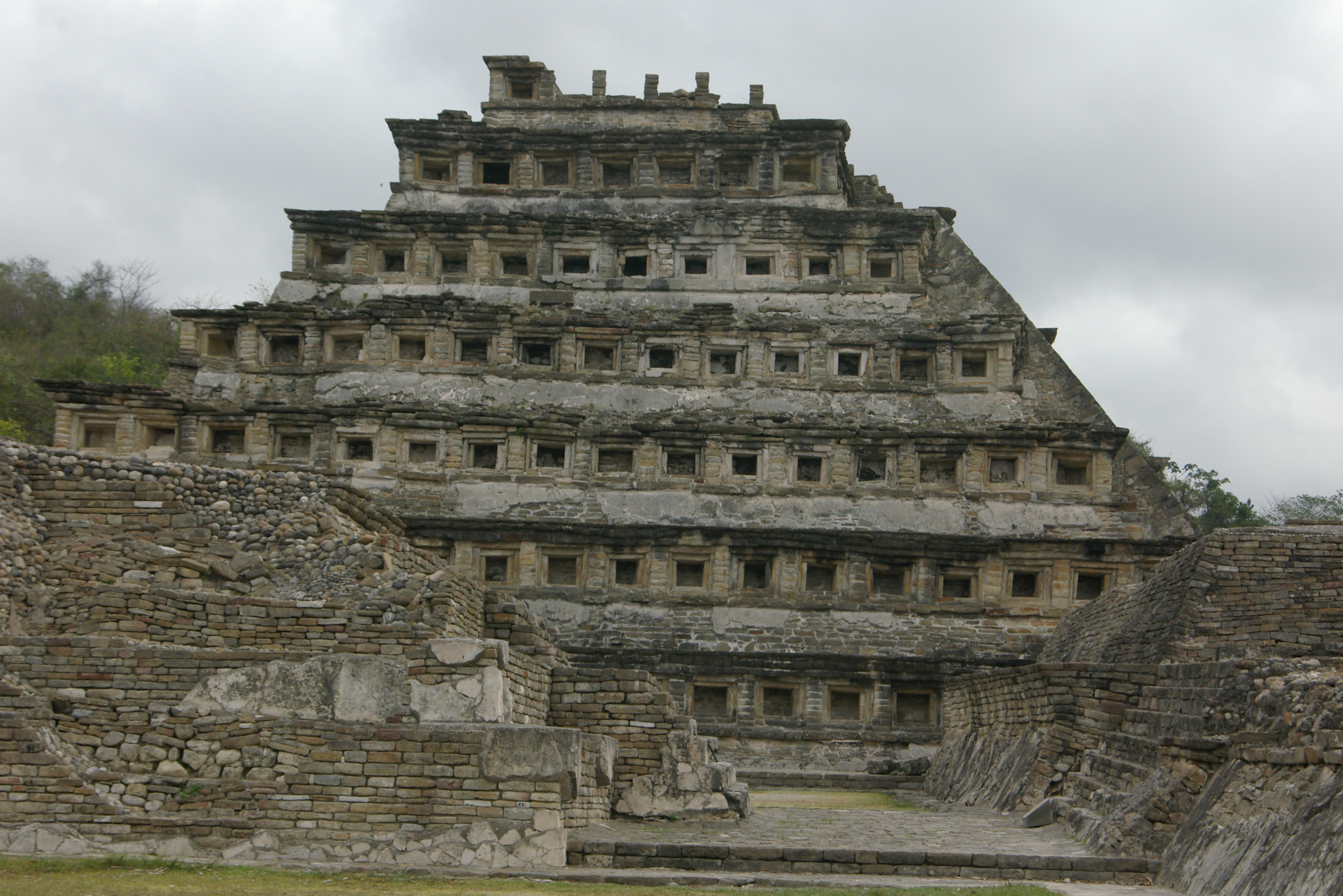
33,000 kms under the belt in our adventure of South, Central and North America; 10,000 kms since we returned to this part of the world; 2,750 kms in Central America. More diesel to fill up and onwards this time to the first Mayan ruins in Mexico – Kohunlich. Pulling out of the garage the sun rising at our back we left the filling station cruising along Ruta 180 directly due west. An hour later we hit the turn off and a pothole riddled narrow access road down to the entrance of the Mayan site set in thick jungle that is famous for the ‘Piramide de los Mascones’ (Pyramid of the Masks). Ten foot high stucco masks of the Sun God, the thick lips and prominent features reminiscent of the Pre-Incan, Olmec sculptures, the masks were most impressive especially the fact they date back to the period approximately AD250-600.
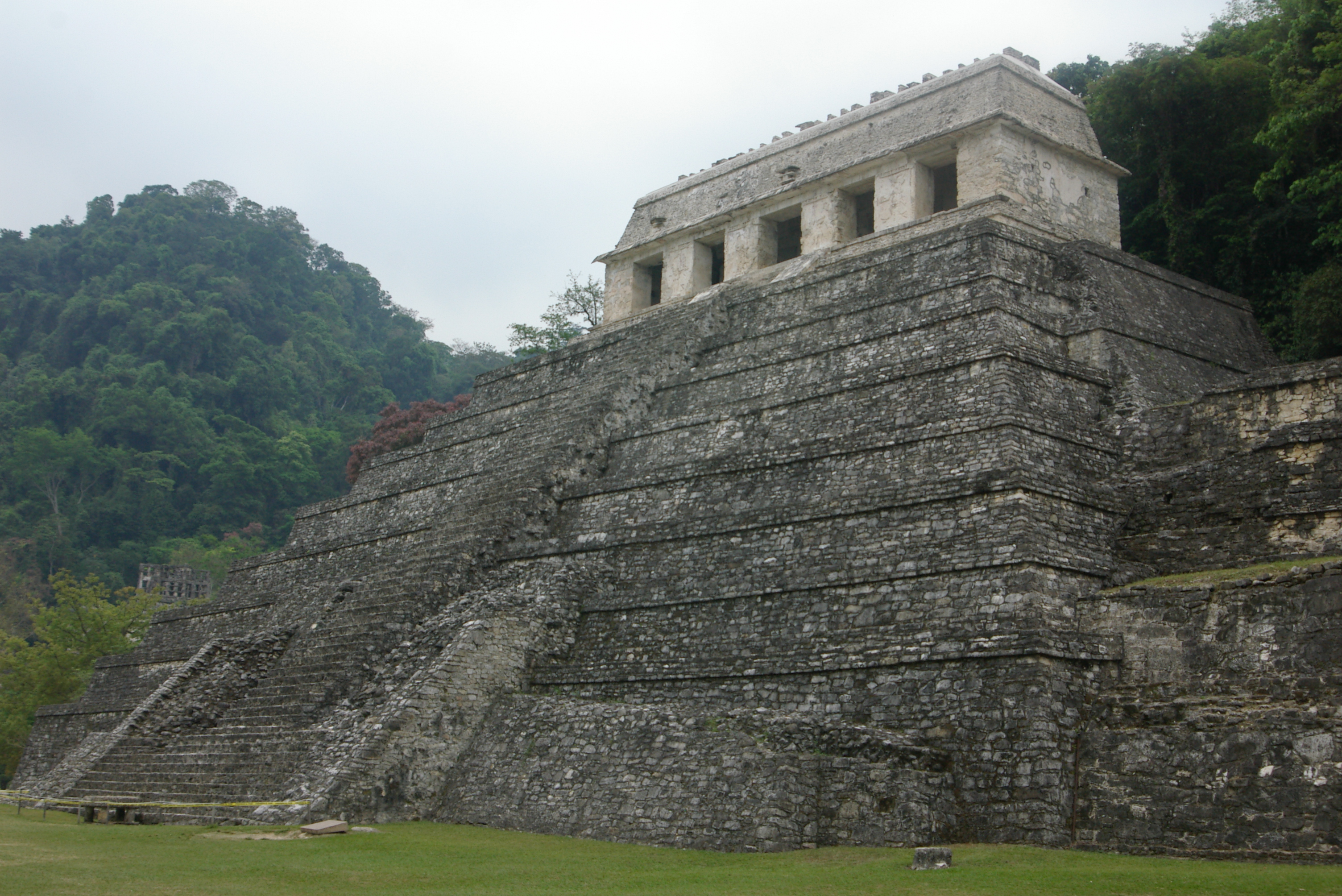
Hanging a left it was back to Ruta 180 and further westwards to the town of Palenque and the ruins of the same name first overnighting in Escarcega. In doing my research I learnt it was best to visit the ruins early in the morning. At 8am the next day we were at the entrance of the mighty Mayan Ruins of Palenque, the third of the series of our selected Mayan ruins after Copan in Honduras, Tikal in Guatemala. Palenque is a physically challenging site with steps, steps and more steps. Well as I said before “When the going gets tough, the tuff get going!!” Built at the height of the Classic Period on a series of artificial terraces surrounded by jungle, set high on a ridge with a super mirador to the north, Palenque is reputed to be one of the most impressive of all Mayan sites in Mexico.

From about the Fourth Century AD Palenque grew from a small agricultural village to one of the more important cities in the pre-Hispanic era. It is thought to have aquired importance when a local dynasty was founded and the first Governor known as K’uk Balan 1 (Jaguar-Quetzal 1) was enthroned circa 431 AD. From the evidence of certain apertures in some of the retaining walls it was obviously constructed for defensive purposes. In the centre of the site a palace with an enormous warren of buildings complimented by a tall square tower rising above them which could have been a watchtower or even been used as an astronomical observatory. Learned scholars believe that the tower was constructed so that Mayan royalty and priests could watch the sun falling directly into the Templo de los Inscriptiones during the December 22 winter solstice. The Temple of Inscriptions is one of the rare Mayan pyramids constructed to have a burial chamber incorporated at the time it was built.
With the big three Mayan sites of our choice behind us there were but a few lesser sites to call in and visit en route north along the coastal road hugging the Mexican Gulf. Mozeeing out of our treetop lodgings we ventured back to Ruta 180 and onwards to the city of Villahermosa. En route we were stopped a number of times at Military Checkpoints. It seems to us that the Government is still keeping strict control over the Chiapa Region which was the centre of the Zapastista uprising of January 1, 1994 when an armed peasant group calling itself the Ejercito Zapatista de Leberacion Nacional (EZLN) Zapatista National Liberation Army attacked and ransacked government offices in San Cristobal, Ocosingo and a few other towns.
The Government ruthlessly retaliated and troops evicted the Zapatistas within a few days, approximately 150 people were killed. Although the rebels retreated to the southern jungle of Chiapas they had succeeded in drawing the attention of the world’s media to the situation in Chiapas. It was the EZLN’S goal to overthrow the hold of the areas wealthy minority on land, resources and power in the State, which had left many Indians (Mayans) and other peasants impoverished, lacking in education, health care and civil rights. The Government promised to look into the matter but of this date nothing has materialised except for heavy handed military patrolling of the area and many checkpoints along the main roads leading to and from Chiapas. Only once was our vehicle glanced into and actually casually searched, no problems only routine, then waved on our way.
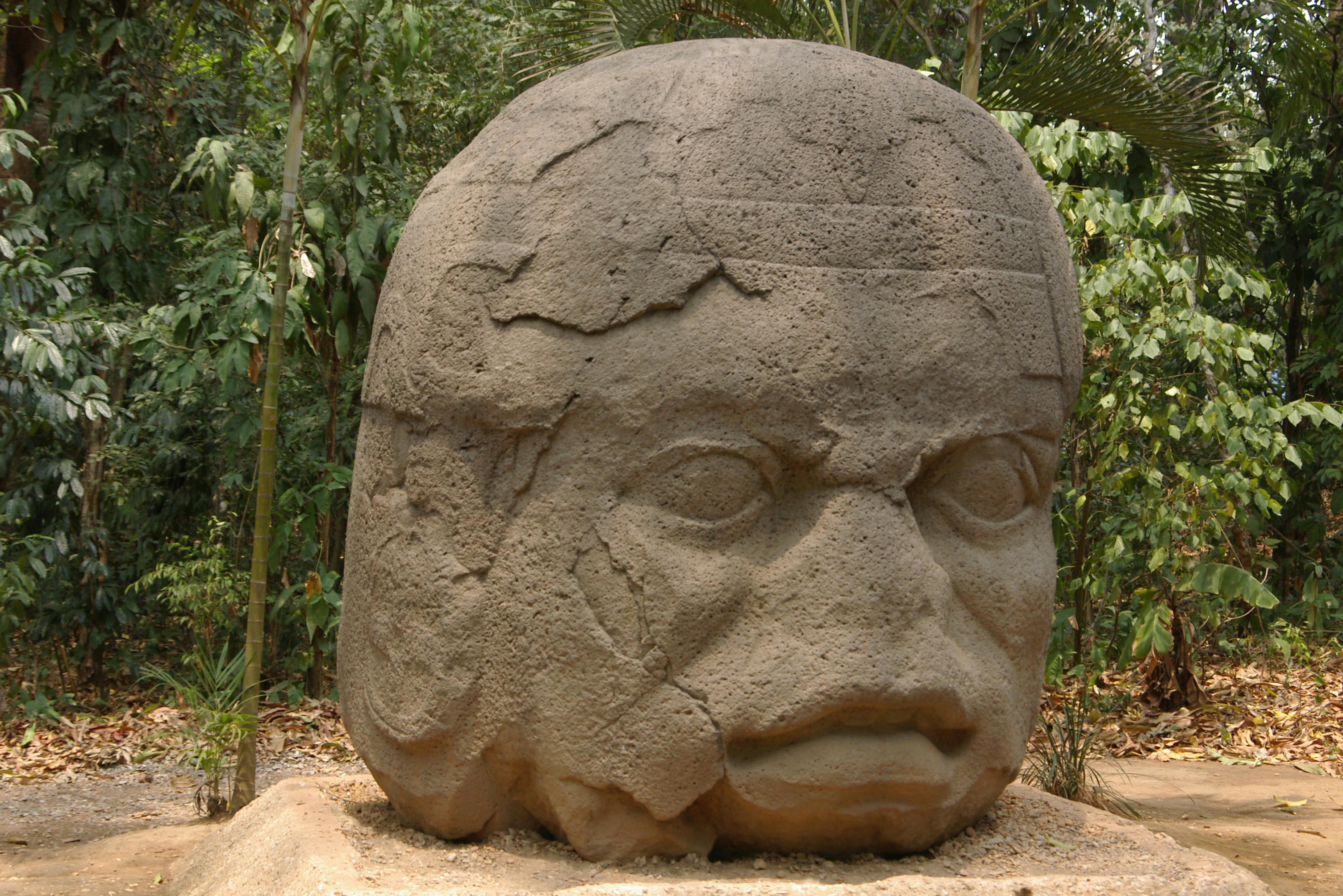
Zooming through Villahermosa we ventured over the river, pulling in at Parque Nacional de la Venta. Going back a bit in time in the year 1925 an expedition of archaeologists discovered huge sculptured human and animal figurines, urns and altars in the almost impenetrable forest at La Venta, once the centre of the ancient Olmec Civilization. In the 1950’s the monuments were threatened with the discovery of oil nearby so the poet Carlos Pellice made arrangements and had them hauled out of there and re-sited in a woodland area close to the city of Villahermosa. Thirty three exhibits are set in various clearings in the woods, the huge monoliths – one of the heads standing 2 metres tall and weighing in at a colossal 20 tons – are Olmec a pre-Mayan culture that flourished 1150-150 BC.
Heading north out of the Parque we were immediately back onto Ruta 180, this time a short haul. Had, had enough of driving for awhile – can you blame me?! Pulled into ‘Neptuno Trailer Park’ and set up camp at water’s edge overlooking the Gulf of Mexico and near a tall coconut palm, not under it lest a nut fell on our nuts, excuse the pun!! You think that I am kidding? It’s not a joke, many people here in Central America have died from just such an accident.
At our camp-site we reached an all inclusive deal with the family who owned the park to have meals twice a day (breakfast and dinner) with them and good Mexican home cooking for a change. I have heard and read about the Mexican hot foods but this must take the cake and here is one for the book!! Walking back from the ablutions I noticed a vendor selling multicoloured lollipop mangoes to Mexican kids and folk camping nearby. As I got to him I ordered ‘dos, por favor’ (two please). The vendor took a mango, cut a small piece off the stalk end and jammed a small dowel into and up the pip and ‘valois’, you had a lollipop mango. With a sharp knife he gently peeled it and then from the top made various cuts into it and down so it looked like an oblong flower with huge petals. Then came the ‘coup de grace’ he smothered the fruit with paprika pepper and to top if off a tiny dollop of Tabasco-type sauce onto the tip of the lollipop.
Well, the first bite I had covered my mouth, beard and cheeks (the mangoes were big) in fruit and paprika so I decided to take my sharp knife and cut the flesh from the pip. That was the easy part. I ate it with a fork, a long, long tongue eventually gulping the remainder of the fruit down. It was hotter than hot and my pony-tail stood straight out the back of my head; the little hair I have on top, straight up; my beard and sideburns, straight down and out; my eyes watered; my mouth felt as if someone had thrown a red hot ember into it. It was the hottest, most fiery mango I have ever or will ever consume!!! Only a Mexican could put such dynamite into a normally delicious fruit. You better believe it!!! Ha-ha-ha!!!
Well folks, we have almost reached the end of our Central American jaunt – one more set of ruins, El Tajin (pronounced el-ta-heen) to explore – then it is off to the border of Mexico and the USA.
On the go!! Yes, on the go again. We left our campsite on the Gulf of Mexico and set forth to explore the ruins of El Tajin – Totonac for thunder, lightning or hurricane, all of which happens here in this part of the world come summertime.
Not much is known about the ruins only that it is believed the Totonacs occupied it from 100AD onwards reaching its peak from 300-900 AD, finally the city was abandoned in 1200 AD possibly after attacks by the Chichimecs only to be rediscovered by the Spaniards in 1785 when an official on a search for illegal tobacco plantings stumbled onto El Tajin. In spite of extensive reconstruction in the early 90’s El Tajin retains an aura of mystery. Some of the special features are rows of niches, square or rectangular in format on the sides of buildings and the presence of many ball courts and sculptures showing human sacrifices connected with the game e.g. it is said the team or players that lost were sacrificed to the Gods.
In modern day Mexico there are still approximately 260,000 Totonacs descendants living in and around this part of the world intertwining Catholicism and their ancient beliefs. Their chief deities are their ancestors, the Maize God the Sun and the Lord of Water and Thunder, St. John. Then there is the Devil who rules the kingdom beneath the earth. Some of the Totunacs in this day and age believe that the earth is flat, the sky above a dome and that the sun travels beneath the earth at night.
Back in the Cruiser and off again driving through the area known as Totonacapan the home of the vanilla industry but also close to the oil city of Poza Rica which was established at the time when the second largest oil deposit in the world was discovered on four ranchos (farms) in the region.
Skirting the city we wound up back on Ruta 180 ever north eventually reaching a major city this time involved in the shipping of oil and the manufacture of steel oil/gas platforms – the busiest port of Mexico, Tampico. Mid-morning as we again made our way around the perimeter and onwards, by late afternoon having covered 720kms we reached the Mexican Aduana.
Many a bad report of kidnapping, highway robbery, molestation and crime involving tourists had been reported by travellers in Mexico. At no time were we stopped by the Federales de Caraterra (patrol cars) and when we were flagged down and directed by the Military to pull over, these youngsters in uniform were always polite, however, stern and businesslike but never overbearing. At no time during our stay in the country did we feel threatened or in danger. We had a wonderful fortnight exploring most interesting archaeological sites and chilling out camping on the Costa Esmeralda on the Mexican Gulf. Mexico in fact was far more developed than any of the other Central American countries, the traffic was orderly albeit moving fast and at times exceptionally fast. There was wealth to be seen and also abject poverty. Huge industry e.g. massive oil refineries and construction of ginormous gas and oil platforms etc. Furthermore we saw organised agriculture, vast cattle ranches, sugar cane estates, extensive pineapple farms and towards the border as far as the eye could see sorghum growing. As a matter of fact Margaret and I worked it out from the last time we filled up Tubby in that country we drove 160kms along these fields either side of the highway north – it just went on and on. We really enjoyed Mexico, its heritage, landscape and most hospitable peoples.
The first thing that struck us as much as the contrast in wealth between Belize and Mexico that there was a much greater differentiation between the US and the latter. No wonder that so many Mexicans and other Latinos are continuously trying to make their way north even if it means risking their lives traversing the deserts of northern Mexico and Texas, New Mexico, Arizona and southern California to enter the domain of their rich and productive neighbour.