

Editor’s Note: This Washington Backcountry Discovery Route article was originally published in Overland Journal’s Summer 2023 Issue.
Photography by Kris Newsom
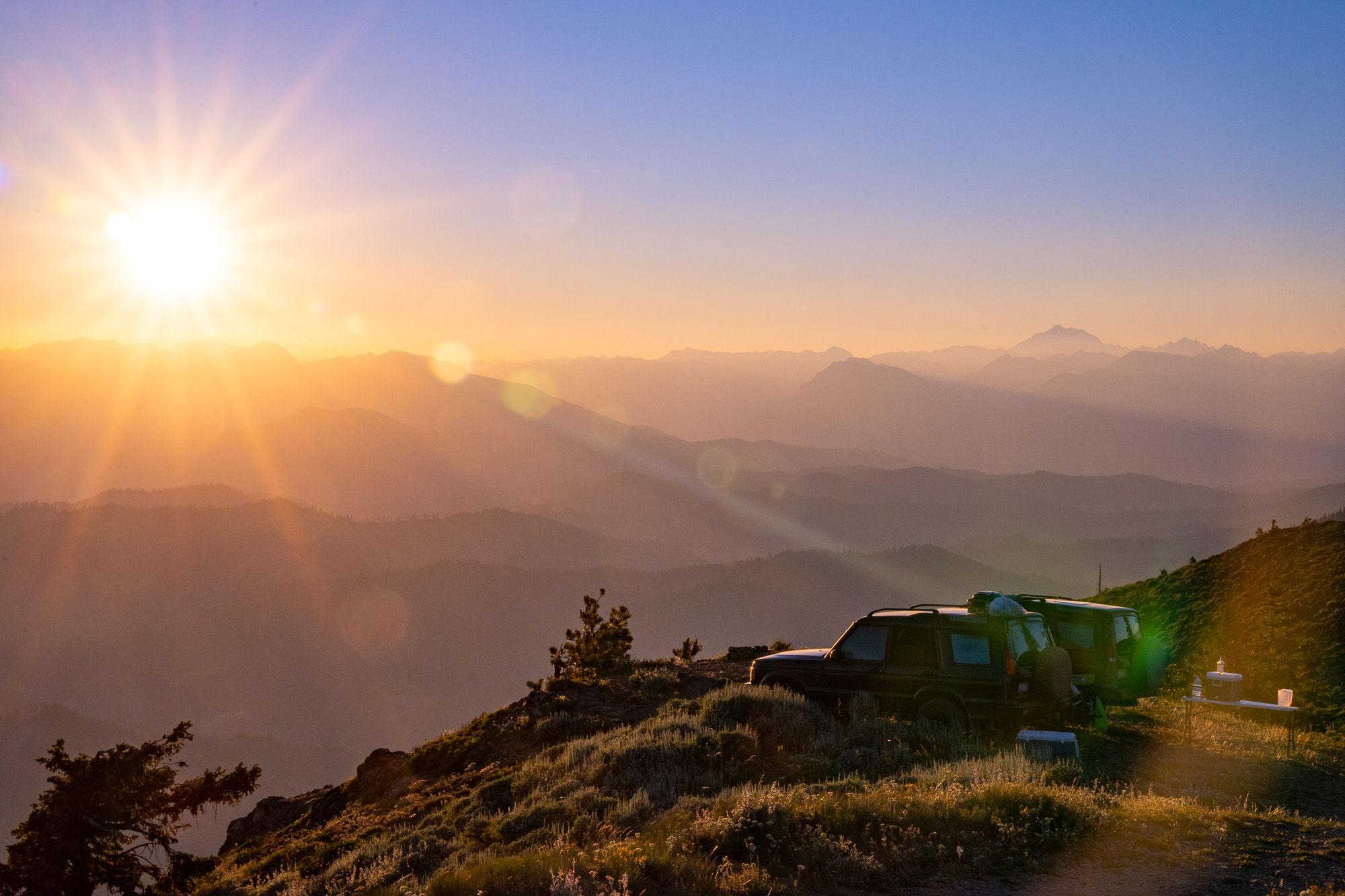
Perched on the edge of the Lion Rock escarpment in Washington’s central Cascades, I leaned back in my chair and watched the molten sun drip behind Mount Stuart’s jagged silhouette. Behind me, a clicking camera pierced the warm breeze as my friend Kris caught the day’s final rays filtering through the haze. Before me, layers of green softened and brightened as rows of forested foothills spilled toward the glowing horizon.
From the tranquility of our airy campsite at 6,300 feet, it was hard to believe that 80 miles to the west lived 4.3 million people in the central Puget Sound. Among the empty alpine reaches, I was content to relax among a small group of companions. Joining us on this late July foray were Rob Vowles and Steve Biggs, who rolled up in a cloud of dust having broken free of Seattle’s tractor beam, along with TJ and Gabe Millard from the Olympia area. Cast against the orange sky, our Land Rover Discoveries were a well-aged pairing for this excursion along the Washington Backcountry Discovery Route (WABDR).
The WABDR is a 600-mile network of dirt roads and trails traversing the state from the Columbia River to Canada along the eastern slopes of the Cascades. Established by adventure motorcyclists, the route has gained popularity among the four-wheel-drive overlanding community. In 2017 it was not yet the magnet it is today. Back then, six days felt barely adequate for my first trip along the crest. Yet I hadn’t actually completed it. About halfway through, a landslide blocked Section III of the route, requiring a detour that involved a trailside fuel pump replacement and a race to beat an advancing wildfire. Five years later, I was back to drive the heart of the route, Sections II through IV, and finish the missing link.

TJ Millard approaches camp along the basalt cliff edge of Bethel Ridge.
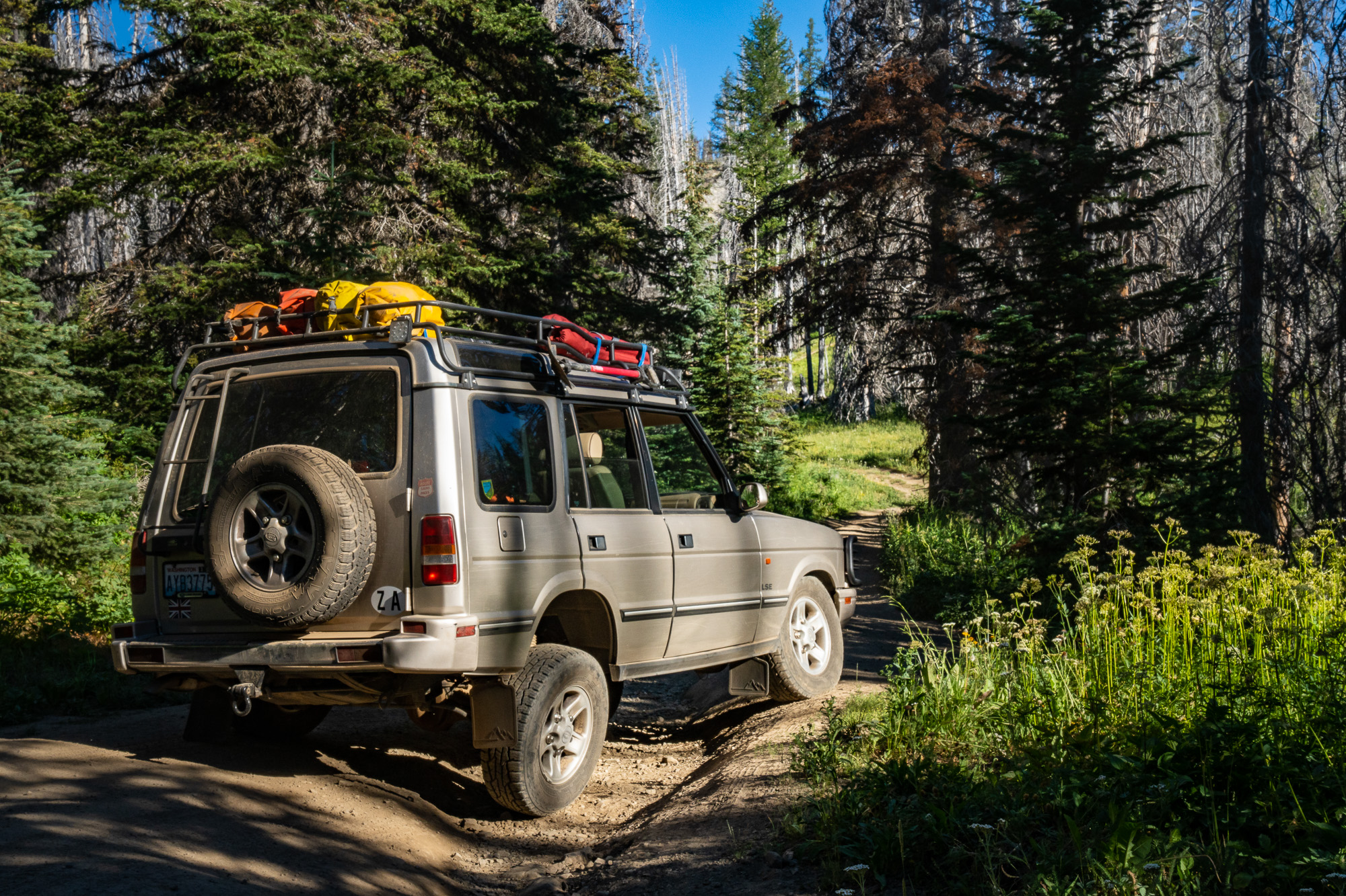
Two days earlier, I had departed Seattle, meandering over the old-growth flanks of Mount Rainier. Patches of snow still skulked in the shadows at Chinook Pass. Twisting up the dusty switchbacks above the Tieton River, I kept one eye on my engine temperature data. This was the first steep climb, and attentive maintenance has not dispelled a healthy paranoia. The WABDR gains over 72,346 feet of elevation along its length, with individual climbs surpassing 5,000 feet, straining the abilities of vintage cooling technology.
The pine slopes opened onto the cracked basalt spine of Bethel Ridge. Over my shoulder were precipitous views of the glaciated volcanic symmetry of Mount Adams, the shimmering turquoise visage of Rimrock Lake, and the verdant Tieton Valley. The loose preparations for the trip ran through my mind as the afternoon shadows lengthened, and I jostled along the rocky track hugging the edge of the ridge. I’d shared coordinates with the other drivers, and we had sketched a rough plan. Would they make it to the rendezvous, a craggy promontory jutting over the valley?
I was relieved to see another Disco parked along the cliff. Shan Gull and his son, Johnny, were already enjoying the views. This was our first meeting and illustrated another aspect of the route. Approximately every 100 miles, the track intersects an east-west highway, making it convenient to join or leave the route at multiple points. If you don’t have the full week the trip deserves, you can choose your own adventure and sample the contrasting flavors of the sections à la carte.
As the sun faded, the final cast members for act one entered stage west trailing clouds of dust. I’d met Kris in 2011 on a support team in the Baja 1,000 race. He had an appetite for adventure and leaped at my invitation for this trip on short notice. TJ and Gabe were new acquaintances, TJ being the proud but anxious new owner of a Discovery series II on his first real off-road outing.


The official route map establishes six sections divided by major road crossings. Having followed this formula on my first traverse, I wanted to try a new approach. The best camping was farther from pavement, so my plan was to stagger the sections, ending each day partway into the next segment. Atop Bethel Ridge at 6,200 feet, the temperatures were cooler than in the valley, the vistas across the southern Cascades were captivating, and breezes kept the mosquitoes away.
Awake at 5:00 a.m. and on the trail by 6:15 a.m., we swayed over ruts and rocks, weaving in and out of the forest as the dust danced in sunbeams. Early starts were essential, with temperatures in the valleys forecast to reach 107°F over the span of the trip. Distances are deceptive on the WABDR. Eyeing the map, it’s tempting to think that 100 miles will take a handful of hours. Twisting trails, unpredictable surfaces, and relentless climbing keep speeds low, and the continually changing landscape is so beautiful that it feels criminal not to savor the views. Despite our ambitions, 10 hours were on par for a section, balancing the need to cover ground with the desire to enjoy the journey. As we descended Bethel Ridge toward the Naches River, I wondered if we’d reach Lion Rock before dark to meet the rest of the cast for act two.


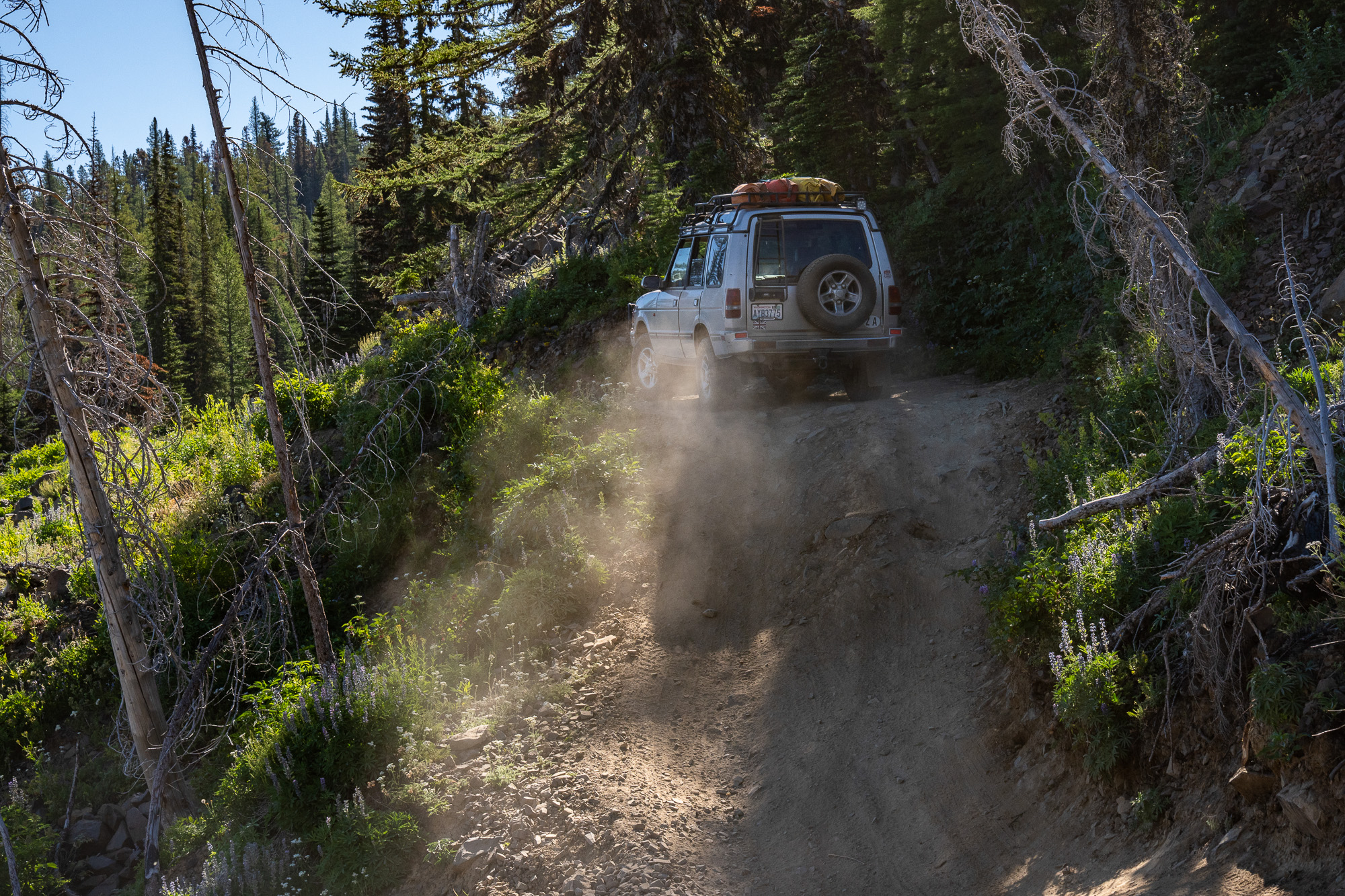
What goes down must go up on the WABDR, and Cleman Mountain presented the first of three climbs for the day. The sun inched higher, filtering through the ponderosa pines. We topped out on a bare, rocky ridge with Mount Rainier towering behind us. Shan’s Disco was feeling the strain of the ascent. Certain that he had an air bubble in his cooling system, he attempted to vent it by easing open a hose. Shouts pierced the still air as a geyser of steaming coolant sprayed him and Johnny; they were lucky to escape without injury. After topping off his reservoir, the Council of Driveway Mechanics reached a consensus that the issue was a leaking head gasket, rendering the imminent future of the Disco uncertain.
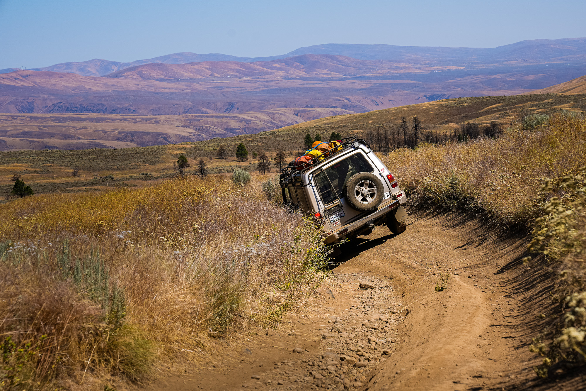
The twisting descent of Cleman Mountain gave Shan time to consider his options. Not wanting to risk further damage, he peeled off and limped back to Seattle before we started up Umtanum Ridge. As the raven flies, we were scarcely 25 miles from our campsite on Bethel Ridge, yet the landscape looked like a different state. Standing on the broad, barren shoulder of Umtanum Ridge, I remembered my first experience driving this terrain. Gazing north beyond Mount Stuart, the distant horizon sparked a question: how far could I go?

Leaving the tight forest trails behind, the airy flanks of Umtanum Ridge introduced expansive and open terrain.
The arrow-straight byways bisecting farm fields felt unnatural after snaking through rocky canyons below the ridge. In Ellensburg’s sweltering outskirts, we refilled our tanks and coolers. Being around other people jolted us out of our trail rhythm, and we hastened for the isolation of empty ridges.
A skeletal forest of burned trees bleached by the sun stood like sentinels above the irrigated valley. Creeping skyward in triple-digit temperatures, we sought respite in the cooler elevations. Green meadows greeted us on the approach to Lion Rock—the outcropping was all ours. A frigid beer was a welcome reward for 11 hours of sweaty, dusty driving. Rob and Steve arrived, asparagus and steaks sizzled, and the day’s adversities faded into the starry sky. We were already partway into Section III, awash in anticipation of the next day’s reveal.
Cool alpine air and soft light trickled through the stands of fir trees. Passing our 2017 turnoff, we entered terra incognita to discover sun-drenched meadows, steep and winding roads, and dense forests rich with evergreen aromas. We floated up the trail in a Cascade reverie. And suddenly, there it was: the landslide.
Kris and I surveyed on foot. Piles of splintered trees lay jumbled across the slope, and heaps of earth were flung haphazardly down the mountain. A broad swath of the trail had been buried in a moment of upheaval. In 2017 there would have been no crossing it, but the work of trail crews, weather, and wheels had tempered this once insurmountable obstacle into an engaging stretch of driving. Everyone eased through and onto the exposed cliff edges beyond, careful to avoid the sharp rocks. The biggest smile was TJ’s, having successfully tested both his abilities and his Disco’s.


Descending to the town of Cashmere, the longest climb of the route loomed ahead. We could take on the 5,000+ foot ascent of Chumstick Mountain in the peak of the heat. Or we could float in the Wenatchee River until temperatures dropped into the balmy nineties. Rob and Steve charged ahead while TJ and Gabe chose to end their adventure, having enjoyed their introduction to off-roading. Kris and I relaxed in the riverside shade before strategically relocating to a brewpub for dinner. Accepting that the sandstone valley wasn’t getting cooler, we eased back onto the route.
The ascent of Chumstick began in parched Nahahum Canyon and climbed into the forest. The final approach traversed an exposed slope and corkscrewed up to the rocky summit. Steve and Rob welcomed us on the bald, windswept peak. The sunset and 360-degree views from the top made the toil worthwhile, and the night sky put on a dizzying display of stars.
Kris and I rolled out at 6:00 a.m., parting ways with our friends who preferred a casual start to the return journey. Tracing the convolutions of Mosquito Ridge and Roaring Ridge, we coasted to the sleepy town of Ardenvoir. Content at having completed the missing link but sorry to leave the mountains, we steered for home. As always, we wanted more time on the trail, but it’s good to leave a little hungry.
Back in Seattle, I learned that wildfires had started on Sections I and II in the immediate vicinity of the route. Despite the accessibility of the WABDR, it’s still wilderness subject to nature’s unpredictable power. We were lucky to evade the blazes and uncover the rewards of terrain and scenery on Section III. Whether sampling the tasting menu or feasting on the entire banquet, the wonders of this discovery route are worth plenty of return visits.

Our No Compromise Clause: We carefully screen all contributors to ensure they are independent and impartial. We never have and never will accept advertorial, and we do not allow advertising to influence our product or destination reviews.