

To honor the 20-year anniversary of Overland Journal, we are revisiting special heritage content in the upcoming 100th issue of the magazine. Originally published in Overland Journal’s Winter 2009 issue, this article is part of that celebration.
It is well to observe the force and virtue and consequences of discoveries; and these are to be seen nowhere more conspicuously than in those three which were unknown to the ancients; namely, printing, gunpowder and the magnet. For these three have changed the whole face and state of things throughout the world; the first in literature, the second in warfare, the third in navigation; whence have followed innumerable changes; insomuch that no empire, no sect, no star seems to have exerted greater power and influence in human affairs than these mechanical discoveries. – Francis Bacon, Novum Organum, 1620
When the Chinese first discovered the magical ability of lodestone to align itself north to south, sometime around 200 BC, they didn’t even think about exploiting it for navigation. It was, instead, viewed as a marvelous new tool for the already ancient practice of favorably orienting buildings and other structures using cardinal directions—probably originally intended to maximize solar gain in winter, but subsequently developed into an intricate system that envisioned polarized energy fields and investigated ways to locate areas of positive flow. The practice was called after the Chinese phrase “wind-water,” or feng shui. Yes: the very same system, in name at least, that was seized upon by new-age entrepreneurs and used to tell hundreds of celebrity homeowners yearning for Qi which way to align their espresso machines.
It took a few centuries before the light went on that lodestone was also useful for finding one’s way home to one’s properly aligned house. Around the 8th century AD, the Chinese figured out how to magnetize needles with lodestone, which led to floating needle-and-cork-style compasses similar to what we made in grade school. By the 1200s, these were certainly in use on coastal boats in both China and, likely thanks to Arab traders, the Mediterranean. And in 1405, a bold Chinese navigator named Zheng He documented his use of the compass as a long-distance route-finding tool, on the first of seven voyages around the Indian Ocean at the head of a fleet comprising at least 200 ships and 20,000 crewmen (with a command ship that, according to the most reliable reconstructions, might have surpassed 250 feet in length, dwarfing Columbus’s 70-foot Santa Maria).
Europe contributed to compass evolution around 1300 with the invention of the dry compass, which employed a needle balanced on a fine pivot rather than floating in water. (Later on we realized that the seemingly retrograde step of filling the compass with liquid—usually alcohol or oil to prevent freezing—helped dampen the needle so it stabilized more quickly.)
From there, compass design advanced slowly but surely. Gimbaled compasses remained stable on heaving ships, and the compass card was developed. Early versions were marked with 32 points, matching the points of wind known by sailors, rather than degrees (although the four main “cardinal” directions were indicated). Around this time the traditional, ornamental arrow marking north became common. However, its origin was not the fleur-de-lys as is usually supposed, but a highly ornamental letter “T,” the first letter of the Italian word tramontana (Latin origin word transmontānus), meaning north wind.
By the 15th century, long-distance sailors had figured out that the compass needle didn’t actually point true north except in a couple of narrow regions on the globe (even the continentally confused Columbus was aware of this), and that the variation from true north varied depending on location. At this time, most people assumed there was a gigantic magnetic mountain range or island in the Arctic to which the compass needle was attracted, but in 1600, the English physician William Gilbert proposed that the earth itself possessed a magnetic field, in a masterful six-volume work titled On the Lodestone and Magnetic Bodies and on the Great Magnet the Earth, which took him 17 years and a reported £5,000 to produce. In 1699-70, Edmund Halley, also of comet fame, captained a voyage around the Atlantic Ocean that resulted in the first reliable chart indicating magnetic variation with isogonal lines, and in 1831, James Clark Ross actually reached the North Magnetic Pole, at that time hovering around the Boothia Peninsula.
That pretty much solidified everything we needed to know to make the compass an indispensable item for any explorer, on sea or land. Hand compasses were used on 19th-century explorations from the Yangtze to the Yellowstone (the silverplated compass Meriwether Lewis bought for five dollars in 1803 is at the Smithsonian). The problem of how to accurately sight on a distant landmark while at the same time fixing its azimuth (or bearing) was solved in 1885 with the patented prismatic compass, which allowed the user to pinpoint the landmark and simultaneously view the compass card through a prism. Later designs employed a mirror for the same purpose.
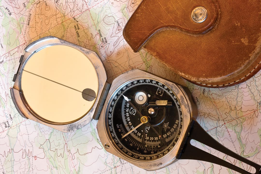
But the facility of the handheld compass for determining precise bearings reached its zenith in 1894. A Canadian geologist named David William Brunton decided there had to be an alternative to the numerous instruments he needed to lug along to carry out his work in remote areas. He was determined to invent a single instrument that would take the place of several, and fit into his vest pocket as well. After numerous prototypes, he introduced the Brunton Patent Pocket Mine Transit, which incorporated not only a sophisticated bearing compass accurate to one-half of a degree, but an equally sophisticated clinometer also capable of readings within 30 minutes of arc. The unit could also be used as a plumb bob for centering a tripod over a survey mark.
Brunton selected the Wm. Ainsworth company (later Wm. Ainsworth & Son, then Wm. Ainsworth & Sons—clearly a busy man), a respected maker of standard transits, to manufacture the Pocket Transit, which would become known to generations of field scientists simply as a “Brunton.” It was an immediate success. By 1929, there were 30,000 Bruntons in the field; by 1959, at least 60,000 were in service.
The Brunton gained its accuracy in part from a generous, 2.5-inch-diameter face, a precise declination adjustment, and a sighting radius when fully extended of over eight inches. Despite its eight-ounce weight—feathery compared to preceding instruments of similar accuracy—the Brunton proved not only precise but exceptionally rugged. The housing was solid aluminum, and a riser locked the needle when the case was closed. Beat-up Bruntons have been passed down for decades still in perfect working order—my own belonged to my scientific illustration professor at the University of Arizona for years before I acquired it.
A Pocket Transit can be confusing to someone accustomed to an ordinary baseplate compass. Most disconcertingly, the degree scale appears “backward,” since the numbers start from zero and climb in a counterclockwise direction. This is because the Brunton is a direct-reading instrument: To take a bearing on a landmark, you normally look down at the compass, using the mirror to align your goal with the sight holes. Once you’re lined up, the needle will point to the correct degree heading. Done. There’s no need to rotate a bezel to box in the needle as on a Silva-type orienteering compass (the disadvantage is that as soon as you move the Brunton, the reading is lost). If you need a precise azimuth, with the Brunton mounted on a tripod (via an optional mount) you can extend the sighting plane to its full length and make incredibly accurate readings—I can confidently shoot bearings to one degree; much, much closer than I can with my Silva Ranger.
The Brunton nearly doubles its usefulness with the clinometer. Geologists use this to measure the dip (tilt) of geologic features. For the rest of us, it’s an amusing tool that can directly calculate the angle of a slope we need to climb, or, with a bit of trigonometry, the height of a tree or cliff.
Today, rather astonishingly, the Pocket Transit is still manufactured in the US, since 1972 by the Brunton company (now owned by compass behemoth Silva). There have been numerous improvements over the early models, such as an induction-damped needle (more effective than liquid damping), and an international model more resistant to “dipping”—the tendency of the needle to tilt and stick as one moves farther north or south, due to the orientation of the earth’s magnetic field. In addition to the aluminum body, one can now choose a fiber-reinforced composite. Most models are now waterproof. Unlike many products, I have no hesitation in saying that a new Pocket Transit is in every way the equal of a vintage model, and in many ways surpasses it.
To be brutally frank, a Brunton is overkill for most orienteering use, and its lack of a base plate is actually a handicap for map work. The joy of owning and carrying one comes from the certainty that you will never encounter a situation for which your compass won’t prove far more accurate than needed, from the equal satisfaction of knowing you’ll someday pass it on to a deserving heir, and of course from the deep connection to history—both the history of the Brunton itself, and the utterly vital role that delicate, swinging needle has played in the exploration of our planet.
Face it: The electronic gizmo in your iPhone will never make that connection.
Resources
kooters.com
Our No Compromise Clause: We do not accept advertorial content or allow advertising to influence our coverage, and our contributors are guaranteed editorial independence. Overland Collective may earn a small commission from affiliate links included in this article. We appreciate your support.
