

Editor’s Note: This South Dakota article was originally published in Overland Journal’s Spring 2023 Issue.
Small and isolated, South Dakota’s Black Hills seemed the ideal place for a self-imposed writing retreat. I’ve been working on a book for years and hadn’t so much as typed a single letter in the manuscript for over four months. I needed a concentrated amount of time that would make up for those lost words—somewhere quiet without distractions.
I should have chosen Milwaukee or something; the Black Hills were about to blow my mind.
When I arrived in Rapid City, fellow writer and friend Michelle Lamphere picked me up at the small airport. We drove 45 minutes southwest to Custer, where she lives, and the Chalet Motel she owns and runs. A small cabin at the Chalet with a kitchenette would be my cozy home for the next three weeks.
Devils Tower
I was there to write but craved exploration, so the following morning, I ventured off to America’s oldest national monument, designated as such by President Teddy Roosevelt in 1906, located on the Wyoming and South Dakota border.
Devils Tower is a rock butte thrust through the earth’s crust roughly 50 million years ago, with striking columns of vertical rock formed through the contraction and fracturing process after its eruption. Many visitors want to see Devils Tower in person after watching Close Encounters of the Third Kind, in which it is prominently featured. During peak season, the nearby KOA campground hosts a nightly viewing of the film, which was shot right in the campground.
I wasn’t interested in any of that Hollywood stuff. The 867-foot tower appealed to me as a hiker and rock climber. I’d miss not having my climbing gear with me, but I still wanted to see the tower in person.
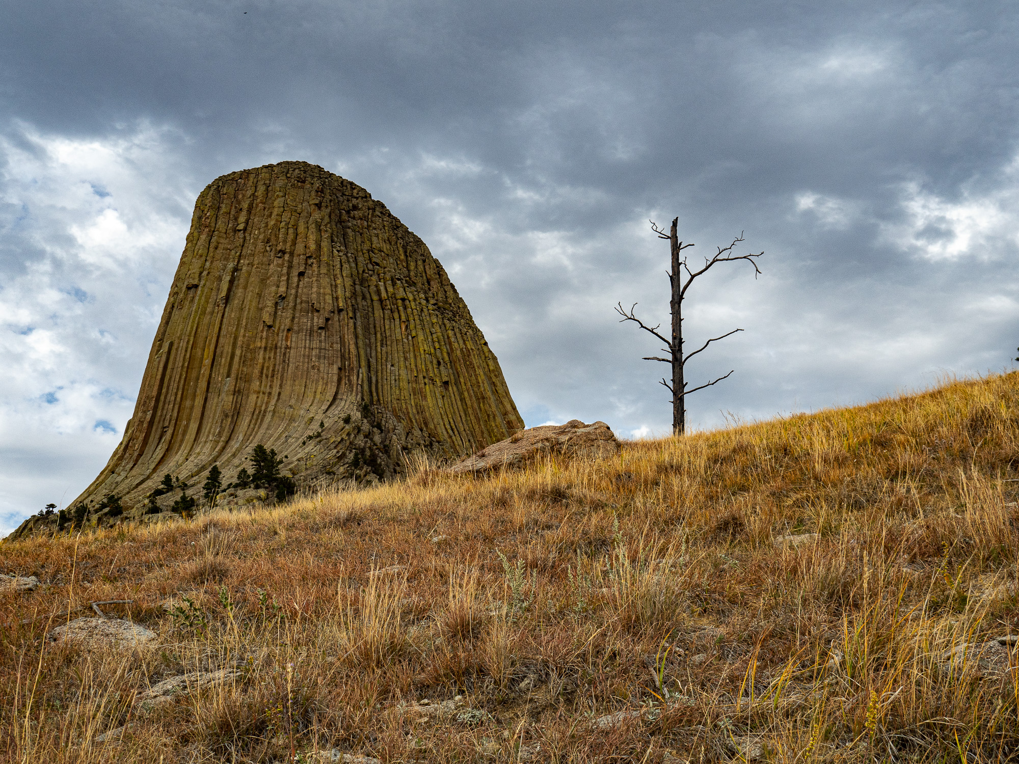
Devils Tower is America’s oldest national monument, rising 1,267 feet above the Belle Fourche River and the surrounding South Dakota prairie land.
Michelle kindly loaned me her SUV for the trip. After topping up the fuel tank in Custer, I headed west on Highway 16, watching for wild buffalo. The thick-hided beasts are common in the area and easy to spot against the blond, grassy plains. For the first two hours, the scenery was prairie-like, with homesteads and farms set off the road on sizeable parcels of land. With next to no traffic—and not a single buffalo—I occasionally took my eyes off the road to scan the horizon for Devils Tower. Not until I was within 15 minutes of the monument did I see it. This section of the Great Plains wasn’t as flat as I’d imagined.
I purchased an annual national parks pass, then continued up the road and parked in a paved lot. Being the end of September, the visitor’s center was closed for the season, though people could still access the monument. I was hoping for some information but settled for a trail brochure the park warden handed me at the gate.
The monument was uncrowded and quiet, except for a strong, hot wind swaying the tall ponderosa pines above my head while I hiked. I was curious about the pieces of colorful fabric tied to the trees and bushes along the trail. These, I later learned, were Native American prayer cloths visitors left behind to represent a spiritual connection to the tower.
After shooting some photos, I hiked along the 1.3-mile Tower Trail encircling the rock’s base. The trail is the closest hikers can get before the vertical climb begins. The rock columns were about 6 to 7 feet wide and looked as though a fat garden rake had made its way up a giant mound of greyish playdough. I didn’t see any climbers, but the brochure said over 5,000 rockhounds scale the tower every year.
I found another trail that went wide out into the grasslands and enjoyed another few hours of hiking and photographing the tower from afar before making my way the two hours back to Custer. Michelle had warned me about deer on the road at night. I didn’t want to hit anything—certainly not in a friend’s borrowed vehicle.
Custer
For several days I stayed close to the cabin and my laptop, though I wasn’t very good at sitting still, especially in a new place. I broke up the long hours of my writing process by taking walks. I love sightseeing on foot as you see so much more that way.
When I first arrived in Custer from the airport, it was around 11:00 p.m., and in the dark, I’d assumed there’d be little to distract me. The main drag was only a mile long with touristy shops, a few gas stations, and one grocery store.
Though Custer is a small town, it comes alive in a deafening way during summer when tens of thousands of motorcycles nearly cause the Black Hills to crumble to the ground from riders traveling to and from Sturgis—South Dakota’s famous annual motorcycle rally. Around the same time, Rev Sisters organizes the Black Hills Moto Fest, showcasing independent films from overlanders around the world.


I began to see Custer as much more than just a small town in the Midwest; in fact, it was more like America’s best-kept secret. The Black Hills are an epicenter for adventures in climbing, biking, hiking, off-roading, swimming, paddleboarding, and kayaking—a playground in the truest sense, all backed by the quiet, pristine beauty of the best of South Dakota.
My favorite place to walk was along the George S. Mickelson Trail—an old railway that has been converted into a pathway. From the motel, I followed the trail for miles, walking under yellow aspen, watching deer in fields backdropped by granite rock bluffs. The trail is 109 miles long and can be accessed from 15 trailheads within the Black Hills. The Mickelson was completed in 1998 and is well-used by e-bikers and horse riders, as well as walkers.
The best times I had adventuring in the Black Hills, however, were with Michelle on her days off. Without her charming, local knowledge, I wouldn’t have known half of what the area had to offer.
One day, we each took a motorcycle from her collection and rode Iron Mountain Road in Custer State Park, winding through the Black Hills in a series of single-lane tunnels cut through granite rock. “Pigtail” bridges, shaped like corkscrews, spun underneath themselves in the narrow canyons and are a motorcyclist’s dream—Iron Mountain Road is 17 miles long with 314 curves and 14 switchbacks. The road would have been jam-packed in the summer months, but in the off-season, we stopped wherever and whenever for photos inside the tunnels and other scenic shots.
Needles Highway, South Dakota
On another day off, Michelle and I drove along the stunning Needles Highway in Custer State Park. Tall fingers of rock line the roadside in stunted formations, some less than a hundred feet high, looking like they could easily be pushed over. These boney buttes were once considered for the presidential head sculptures that later became Mount Rushmore. But it was determined the rocks would erode over time, so another, more-solid choice was made.
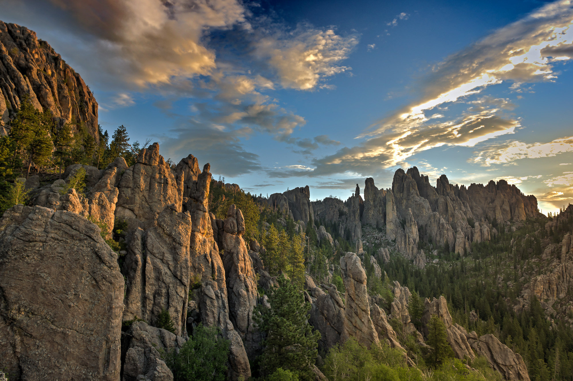
These tall fingers of rock along Needles Highway were almost the location for the presidential head sculptures before Mount Rushmore was deemed more appropriate.
South Dakota, like many places, has a controversial history, with Mount Rushmore contributing to the narrative. The national memorial was intended to honor past presidents, but while it was being sculpted on sacred Native American land by a commissioned artist rumored to have ties to the Ku Klux Klan, Rushmore was already plagued. Since the project’s completion in 1941, Native Americans have lamented the fact that the sculpture was built on Indigenous land.
Occupation of the entire Black Hills has never sat well with Natives. The Lakota have grieved for decades over losing so much of their land to mining, building, and the carving and butchering of their mountains. Yet once it was all said and done, the tribe wanted representation and built their monuments bigger to outshine even Rushmore. In present times, Black Hills locals of all races are sympathetic and supportive of any efforts funding and honoring Lakota traditions.
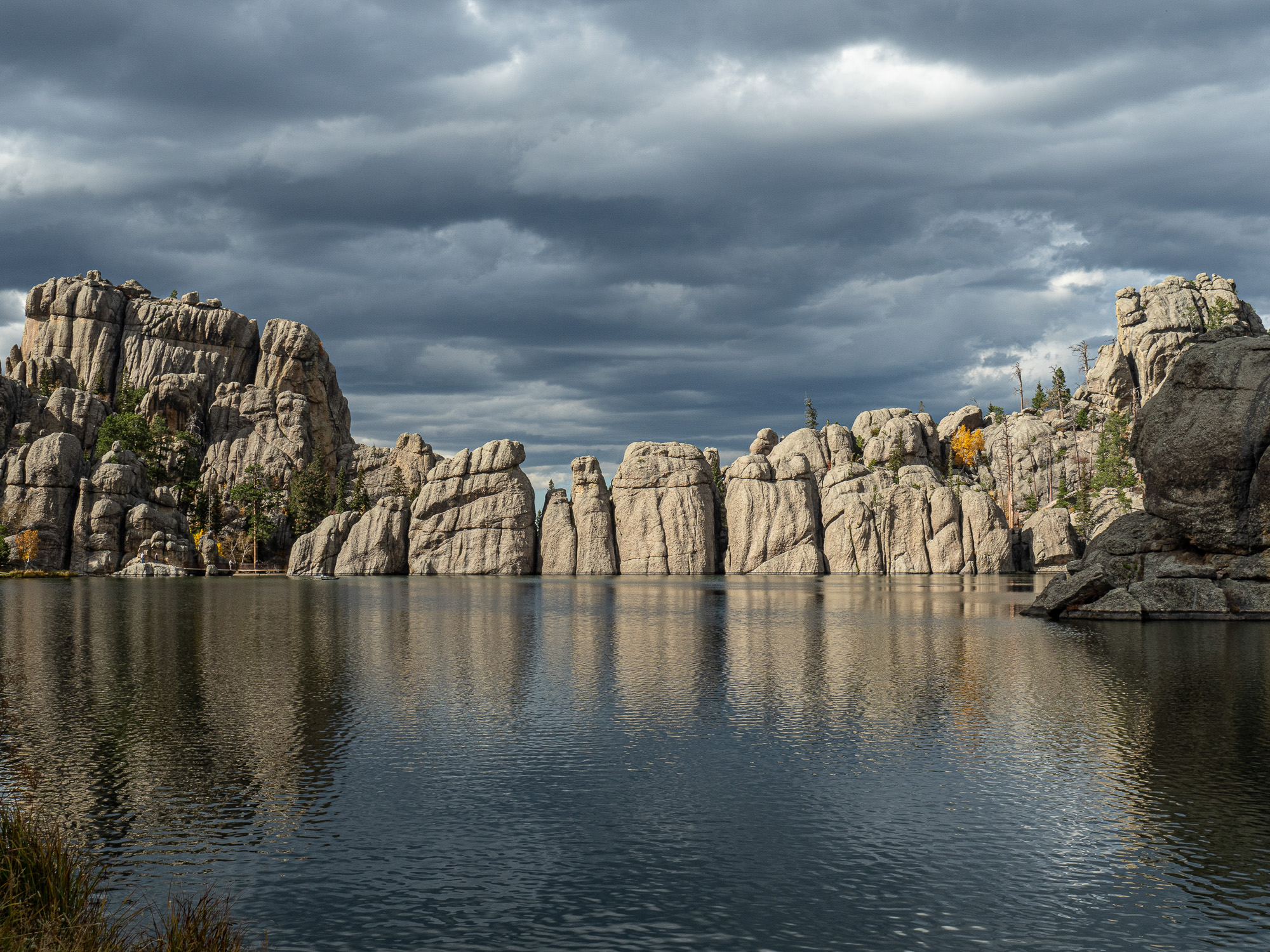
Sylvan Lake is an easy hike and a great picnic area where you can get up close to the incredible rock formations in Custer State Park and maybe see some rock climbers.
We stopped at Sylvan Lake—a beautiful walking and picnic area where, on a still day, the water perfectly reflects a crown of pale, lichen-covered rocks several feet high along Sylvan’s shoreline.
During a hike around the lake, Michelle recounted the history behind the name for the highest mountain, not only in the Black Hills but also the highest east of the Rockies. Until 2016, Black Elk Peak, 7,244 feet, was called Harney Peak, named after William S. Harney—a US Army Cavalry general who commanded his troops through the Black Hills War during the westward expansion in the 1800s.
Under Harney’s direction, the troops killed dozens of Native Americans, including women and children. Having his name tied to the highest point in the Black Hills—a sacred place for the Lakota people—was an insult. In 2014, tribal representatives, also supported by local residents, applied to a federal agency to change the name. In 2016, the US Board of Geographic Names approved the request, and the mountain was renamed Black Elk Peak after an Oglala Lakota spiritual leader.
Moccasin Springs
By this point, I must have looked in need of some relaxation. Michelle offered me a pass to Moccasin Springs, a spa resort 45 minutes south of Custer, and again loaned me her SUV.
I’ve always loved road trips, even if they’re short. And especially on sunny days, with very little traffic and excellent scenery. I continued looking for roadside bison, and this time, I was in luck, as half a dozen black dots appeared in the distance. I parked and pulled my camera to my eye. The 14-150mm zoom lens didn’t quite bring the buffalo as close as I wanted for a good shot, but I still clicked off a few, happy to see the rambling herd here in Wind Cave National Park.
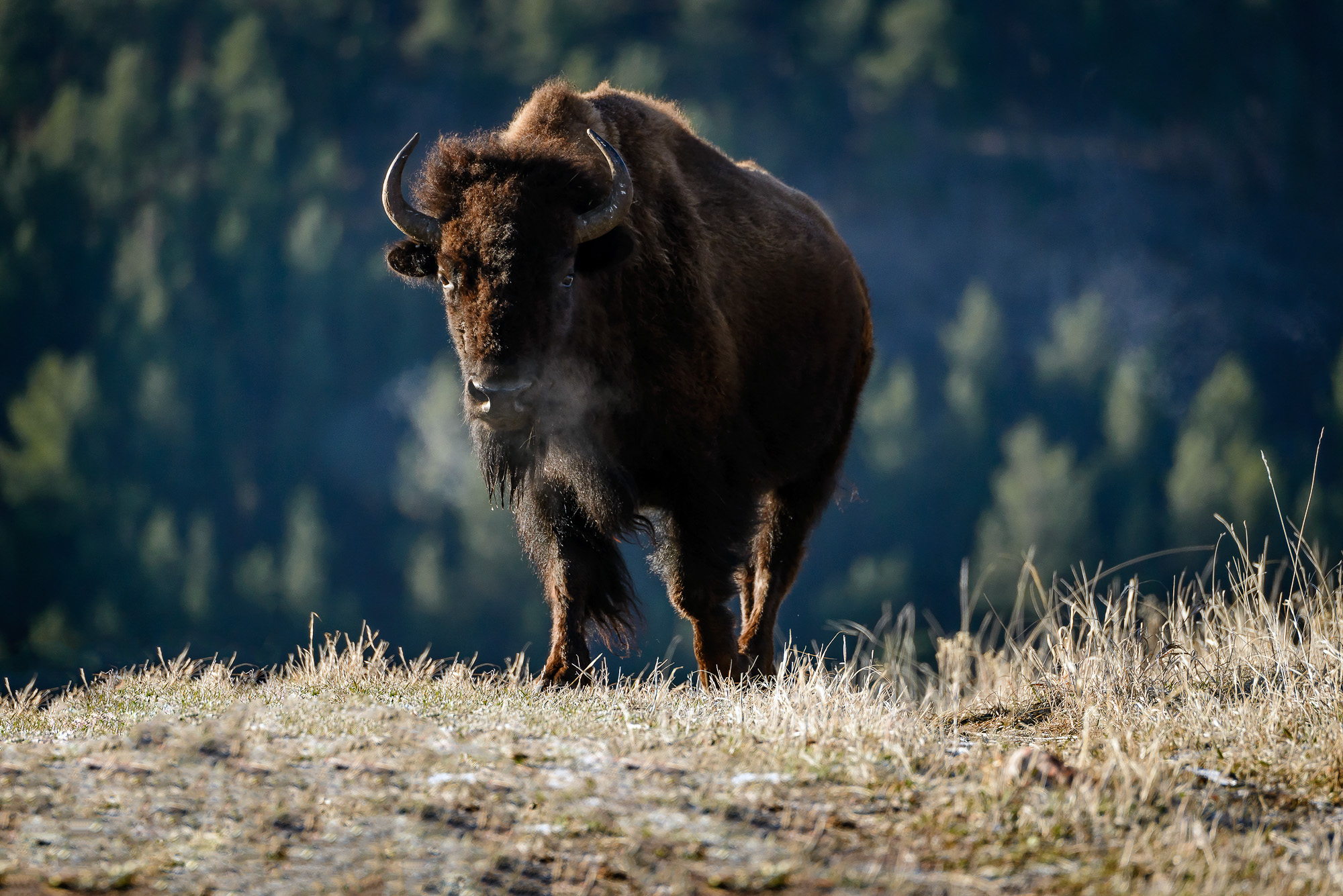
Bison are formidable creatures easily spotted (when they’re around) in the wide-open prairies of South Dakota.
I spent that afternoon soaking in the 100-degree mineral waters at Moccasin Springs, first established in 1881. The bathhouse closed in 1963 until 2014 when a local woman purchased the property and reopened the spa in 2019. She kept its original namesake given by the Native people who honored the medicinal water.
Crazy Horse, South Dakota
Before leaving Custer, I wanted to visit one more place. Crazy Horse Memorial is just a 15-minute drive north of town, so I borrowed the Yamaha XT again and rode to the monument, where there was a celebration happening for Native American Day. Here, I’d find a piece of history in limbo.
Crazy Horse was a Native American warrior who led the Lakota through battle in the late 1800s. He tirelessly and heroically defended his people against US government encroachment until he was bayoneted to death after resisting imprisonment.
The Lakota people wanted to honor Crazy Horse in stone, and work on the memorial began in 1948. A Polish-American architect, Korczak Ziolkowski, was hired for the design. He’d worked on Rushmore but was approached by the tribe because he was trusted as a kind man who was supportive of honoring the Lakota.

The Crazy Horse Memorial honors the Native American warrior who was bayonetted to death while defending his people and their land.
Now, almost three-quarters of a century later, Crazy Horse is still under construction with no signs of completion. Korczak Ziolkowski died in 1982. His wife, Ruth, took over and opted to sculpt Crazy Horse’s face first, hoping to draw tourism. Korczak envisioned the hero riding atop his steed, but a cartoon-like outline on the rock of the animal acts as a placeholder in the meantime. Crazy Horse’s face—27 feet higher than Rushmore’s presidents—was completed in 1988.
Today, Korczak’s daughter, Monique, runs the memorial. Korczak refused to accept government funding and is slowly progressing because it is being paid for solely through admission sales and donations.
Despite mesmerizing scenery and insightful history tours as distractions, I managed to write over 100 pages in my rough draft. My only regret is I was working on an entirely different travel journey by motorcycle and couldn’t include my time in the remarkable Black Hills—a mountainous island floating in the grasslands of the central United States.
Our No Compromise Clause: We carefully screen all contributors to ensure they are independent and impartial. We never have and never will accept advertorial, and we do not allow advertising to influence our product or destination reviews.