
Editor’s Note: Sam Correro, the creator of the TransAmerica Trail, passed away this month. Marianne Todd’s interview with Sam appeared in the Spring 2023 issue of Overland Journal. You can read more about Sam’s life and legacy on Expedition Portal’s Celebration of Life archive.
Sam Correro says he was in his forties when he started mapping the TransAmerica Trail (TAT). He was a relatively new rider back then and wanted to view the United States on its backroads from the seat of his Honda XR600.
In his Counce, Tennessee, home, he pulls a pitcher of sweet tea from the refrigerator and pours two glasses. That same pitcher comes out for other guests, sometimes multiple times a day, for the 20-30 or so riders who pass by and stop at his house on the TAT. They talk bikes and routes, tires and parts, and all things related to two wheels.

At 82, after mapping America’s finest backcountry routes for 37 years, Sam’s still at it.
The TAT originated with more than 4,000 miles of coast-to-coast trails—most of them dirt—that bypassed the country’s towns and took riders deep into lands filled with Americana and amazing scenery. “I wanted to ride my motorcycle in the outback, where I could have some space,” Sam said. “I didn’t want to fight 18-wheelers and drunks.” He’s close to completing a 10,000-mile route to circumnavigate the country. “I only lack Michigan and Wisconsin,” he said. Last week, he finished routes in Indiana and Ohio.
He sells the maps from his Tennessee home or as downloadable GPX files on his website, transamtrail.com. Each year, thousands of riders take their turn at navigating one of the most scenic and diverse rides in the country. The TAT, he says, is a physical adventure.
Ryan Barnes finished his second completion of the TAT this past summer. He did his first TAT adventure in 2018 in his Toyota Tacoma. This time, after being away from bikes for 22 years, he ordered a 2021 Ténéré 700 while working in Iraq, along with the gear he thought he might need. He returned from the Middle East, put it all together, then traversed the country to begin the trail at its origin in West Virginia. When he first started out, dropping his bike was daunting. He’d have to remove gear, sometimes walking it up steep terrain so he could get the bike to the top of a pass filled with baby heads. By the time he finished, he had dropped his bike so many times that he had built the strength to pick it up fully loaded.
“I woke up this morning with a lot of different thoughts in my head as I know others have on their planned last day of the TAT. Bittersweet is the exact word for it,” Barnes wrote in his journal. Hailing from Yuma, Arizona, Barnes had started the trail on June 2 and reached its end in Port Orford, Oregon, 30 days later. “On one hand, you can be proud of the accomplishment of riding across the USA on dirt roads and back roads, highways and byways. On the other hand, ending such a journey after a month of chasing that line on the map leaves something to be desired. I take a deep breath, but I’m too far; I can’t smell it yet.”
Although Sam describes the trail as tame, he well understands the travails of cross-country moto travel. For this reason, he has a built-in safety net along the route, with residents, ranchers, and businesses who will help a rider in need. “They offer their services, be it water, shade, minor repairs, bed and breakfast, or tent camping. These individuals are marked on my maps with locations, names, and phone numbers. They will be respectable to you, so ride with respect for them,” Sam says on his website.
![]()
When Sam began mapping the trail in 1985, he didn’t realize his idea would gain such traction. There are a couple of TAT Facebook groups for motorcycles only, and they have a combined 60,000 fans. It’s nearly impossible to gauge the number of riders on the trail. “I sell maps, but you don’t know how many riders are going or how many have done parts or all of it multiple times,” he said.
The TAT passes in front of Sam’s house, which has a large TAT trail marker on the mailbox. He welcomes the company. “I have a lot of people who have expressed a lot of gratitude.”
A few years back, Mathew Sturtevant stopped by for a visit at Sam’s favorite hangout, Lake Hill Motors and Marine, in Corinth, Mississippi. “He said he had spent nine months on the couch, watching television, depressed as hell. So one day, his wife comes in and has a set of keys in her hand to a dual-sport bike. She hands him the keys and a map to the TAT and says, ‘Get your butt out of the house and go ride it.’ So, he did. He wrote a book about it.”
The Topography of Fear: Finding My Way Through Uncertain Landscapes and My Darkest Fears. How a Coast to Coast Motorcycle Adventure Changed My Life. Twice., is now presented by its author at Overland Expos, where Mathew gives presentations on riding the TAT. The book took eight years to complete and chronicles the 6,000 miles Mathew spent on dirt roads while navigating his life’s travails.
Mapping America’s backroads coast to coast, if anything, was a time-consuming test of mettle. “It took a lot of trial and error,” Sam said. “It was bits and pieces that took me several months to put together because I had to develop a roll chart that tells riders how far they are from their next turn. It gives you all the coordinates.”
At first, he used a simple yellow legal pad and pen. “But I had to stop at every turn and write down the coordinates. That was a pain in the butt. Then Garmin came out with an updated model that I could use to lay down an active log. That meant I could ride the trail, and it would lay down my track. I said, ‘Well, hallelujah.’”
It took four to five years to map just Mississippi, Arkansas, and Oklahoma. Things got faster as Garmin advanced its technology.
Sam advises using a multitude of devices to navigate the trail. Ryan had come equipped with a Garmin XT and a Garmin InReach Mini for emergencies and weather reports but found he used his phone navigation more than anything. He also had the advantage of having mapped his 2018 TAT journey in his Toyota Tacoma. “I built it out for overlanding with a rooftop tent and all that jazz,” he said. On his Ténéré, he changed tires halfway through the journey, moving to a more knobby tire once he reached Mississippi. “I put a Motoz Tractionator Dual Venture on the front and a Tractionator RallZ Dual Sport tire on the back. I needed a more aggressive tire. It was just too muddy.”
Ryan said the terrain is varied. Smooth in some places. Steep and rocky in others.”There are only two places a guy like me can put his foot down; a place where I can reach the ground and a place where I can’t,” Ryan said in his journal. “This is the latter, and with nothing but air between the ground and my toes, the bike slowly decides to take a nap. I step off casually and let its weight be taken on the right pannier bag, then assess the situation and my options.”
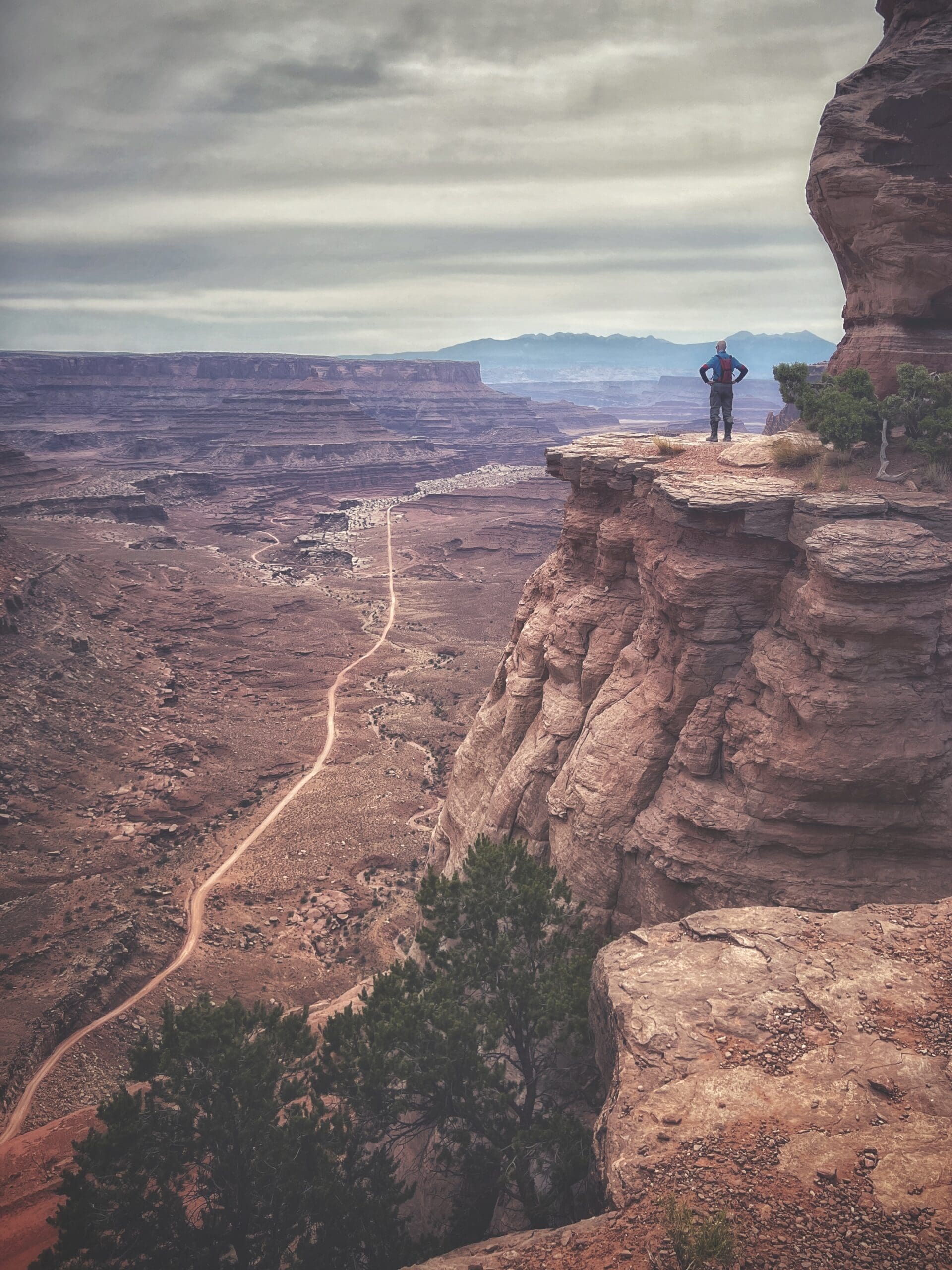
At the end of his moto journey, Ryan had ridden 12,000 miles across the country, twice.“ It was a good feeling coming over that hill in Port Orford. I had passed mountain passes and trails through prairies and all the different ecosystems of the nation, the coastal rainforests, the Rocky Mountains, the heat of the South. To ride across a nation and not touch an interstate—it’s pretty special when you think about what that takes.”
On his final night, he found a quiet campsite in earshot of the crashing waves and opened his journal to write. “No trailers, no flats, no breakdowns, not even one loose screw. It has been a perfect trip, just me and my Ténéré and some new friends along the way. One final time from the end of the TAT. Goodnight.”
As for Sam, he has yet to ride the TAT from start to finish in one fell swoop, but he’s eyeing a Kawasaki KLX300s for a 2023 trip planned with his son. Then it’s his turn to ride the whole thing.
![]()
Until then, he will continue to advise and inspire, serving as a ready source for adventurous souls.
“This past Monday, I had a couple who live in Nashville stop in. They wanted to chat and get some GPS information,” he said. “We wound up having lunch, and while we were talking, two riders pulled up in my driveway, one rider from England and a girl from Ireland. They struck up a good friendship and stayed a couple hours chatting. People come every day. It’s been a lot of work, but people have enjoyed it, and that makes it worthwhile. It’s been an adventure for me.”
Read more:
Tips for Riding the TransAmerica Trail
Dumb or Dumber?: A Half Life Man Learns to Ride
Images: Marianne Todd lead image, and Ryan Barnes
Our No Compromise Clause: We do not accept advertorial content or allow advertising to influence our coverage, and our contributors are guaranteed editorial independence. Overland International may earn a small commission from affiliate links included in this article. We appreciate your support.