Salt River Canyon & the Shelf Road Adventure

1leglance

2007 Expedition Trophy Champion, Overland Certifie
Well with a bit of time between Christmas & New Years the need to play in the dirt was strongly felt. The real question was where to go? Southeast Arizona has a ton of ghost towns and history (Tombstone, Bisbee and more). Western Arizona held some areas I had recently played and want to see more of. But then the memory of passing by the Salt River Canyon on US 60 came back to me and luckily my buddy Waymon was ok with going somewhere neither of us had been before.
salt%252520river%252520self%252520road%252520adventure-1.jpg


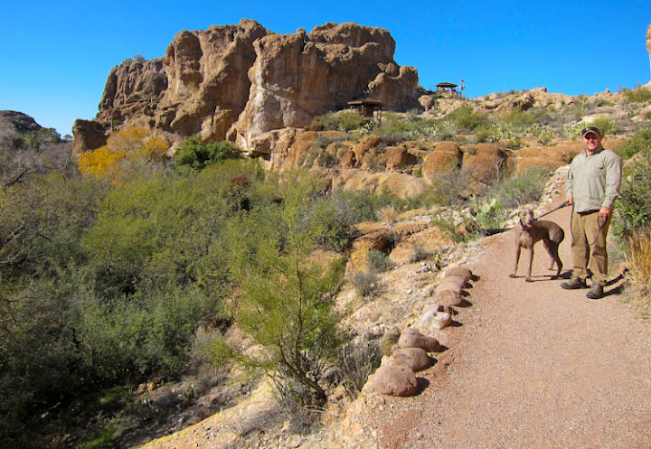
But before we get to the juicy off road bit we all have to admit that there is that nasty bit of highway that has to be covered. Lately I have really been trying to make an effort to find things along the way of interest and in this case we got to spend a bit of time at one of the littlest Arizona State Parks, the Boyce Thompson Arboretum , this is a very cool place to hike around and spend some time trying to figure out what in the world was the original idea :)

I will admit it is very cool to find out about the thing Arizona & Australia have in common as we are planning to spend some serious time there Summer 2012.
salt%252520river%252520self%252520road%252520adventure-2.jpg


Waymon and Lexi (that is the dog) were also getting a kick out of the pet friendly location.
salt%252520river%252520self%252520road%252520adventure-3.jpg


Since my wife is from Peru I am always interested in thing from South America...but again it is just odd to have this in Arizona.
salt%252520river%252520self%252520road%252520adventure-4.jpg

salt%252520river%252520self%252520road%252520adventure-5.jpg

salt%252520river%252520self%252520road%252520adventure-6.jpg
 
Last edited:

1leglance

2007 Expedition Trophy Champion, Overland Certifie
But alas we did need to get back on the road and see what way ahead. But at least when we go to Miami (Arizona version with no beaches or babes) we got to hop out for a quick stop to put together some old iron, newer iron and BIG iron. Needless to say there is some serious mine operations in Miami & Globe and if you are into that sort of giant hole in the ground thing it is impressive.
salt%252520river%252520self%252520road%252520adventure-7.jpg


After a quick lunch stop & fuel for the thirsty Suburbasarus we got into some high desert country. The wind blows cold around here but it holds a beauty of it's own.
salt%252520river%252520self%252520road%252520adventure-8.jpg


Now for some folks this little bit of snow looks like springtime but for us low desert people this is a rare thing. Waymon & I were all giddy on the radios talking about getting to run some trail through the snow & camp in the pines and of course that was easy talk from the comfort of a heated rig.
salt%252520river%252520self%252520road%252520adventure-9.jpg


And then came our first view of the Salt River Canyon where we would get off the highway and into the real adventure.
salt%252520river%252520self%252520road%252520adventure-10.jpg


I thought it would be fun for Waymon to stop at the same overlook that stirred a desire in me to explore the area. You get a great view east & west of the canyon.
salt%252520river%252520self%252520road%252520adventure-11.jpg


And way down there is a little dirt road that goes off in into the mysterious distance following the river. Oh it just makes a man happy to have a 4x4 :)
salt%252520river%252520self%252520road%252520adventure-12.jpg
 
Last edited:

1leglance

2007 Expedition Trophy Champion, Overland Certifie
There is a very cool bridge and an even cooler rest stop that is sadly closed. The stop itself has a little bridge and I wish I had captured a picture of it. Oh well just a good excuse to go back.
salt%252520river%252520self%252520road%252520adventure-13.jpg


There is also an abandoned old gas stop with some real or maybe fake/old buildings. Looks like a tourist trap that didn't have enough tourist. Which is strange as this highway gets plenty of traffic. Then again we we now on the White Mountain Apache Reservation so anything was possible.
salt%252520river%252520self%252520road%252520adventure-14.jpg


Speaking of being on the Res, there were some signs to read through. Some new, some old and some I couldn't quite understand.
salt%252520river%252520self%252520road%252520adventure-15.jpg


But the important thing was we got to the little place to pay our permits...only to find there were no blank permits to be found. But never fear as a Boy Scout I learned to Be Prepared and out came the scratch pad & pen. A quick note with our names, rigs & the date..fold that around our money and into the drop box it went. I know there are people who would have turned around, and there are people who would not have paid, but I figure the money is worth it for the adventure and better to be safe than sorry. Remember the Reservation is a Dependent Sovereignty with it's own police & courts. Do you really want to mess around with them for only $15 per person?
salt%252520river%252520self%252520road%252520adventure-16.jpg


And with that I will leave the story while I go sort some more photos, clean the rig, sort the gear, kiss the wife, hug the kids and pet the dog. Watch for more of the story though :)
 
Last edited:

Lostmanifesto

Traveler
Thanks for sharing. When you can please post up some directions from Phoenix. I'm heading to AZ soon and this looks like a fun day trip. Thank you!
 

1leglance

2007 Expedition Trophy Champion, Overland Certifie
Well I couldn't resist getting a few more pics posted to this report...

After Waymon & I wrote out our own little permit & paid our fees to the drop box we aired down and hit some dirt. Well for a about 100yds or so :)
But that short distance would set the tone for why we called this the Shelf Road Adventure, sure we had some some highway shelf road, but when it is paved and wide you don't really notice. This trip would be 3 days of narrow, dirt & rock roads that almost always had a serious drop off on 1 side. Let the fun begin.
salt%252520river%252520self%252520road%252520adventure-17.jpg


First Camp it is called, and well that purely speaks to it's relative position, not its likelihood of being your first choice.
salt%252520river%252520self%252520road%252520adventure-20.jpg


One thing you notice is all the signs that reference rafting the river. We figured it would be good to let Lexi run a bit while we went and checked out where the rafts hit the water.
Nice calm pool of water to start your trip.
salt%252520river%252520self%252520road%252520adventure-18.jpg


Right next to a fair indication of what would be in store for the future. The river was not running very deep at this time of year, but we would not water level marks along the way that told a story of serious flash floods and a mess of water when the snows melt.
salt%252520river%252520self%252520road%252520adventure-19.jpg
 

1leglance

2007 Expedition Trophy Champion, Overland Certifie
Hey Lost...I would be a LONG day trip...as in leave 7-8am and get back that late or worse. Much would depend on time of year and if the water was running higher than we had.
But directions are easy...
Take US 60 east (it connects to I-10, very easy to spot on a map).
Go through Superior, through Miami, through Globe, and turn Left at the bottom of the Salt River Canyon :)

Make sure to post up a bit advance of your trip here so some of us make show you around.
 

Lostmanifesto

Traveler
Hey Lost...I would be a LONG day trip...as in leave 7-8am and get back that late or worse. Much would depend on time of year and if the water was running higher than we had.
But directions are easy...
Take US 60 east (it connects to I-10, very easy to spot on a map).
Go through Superior, through Miami, through Globe, and turn Left at the bottom of the Salt River Canyon :)

Make sure to post up a bit advance of your trip here so some of us make show you around.

Sounds great. I usually stay with a friend in Queen Creek so I am already out that direction!
 

toddz69

Explorer
That abandoned gas station/stop at the bottom of the canyon is where you used to pay for your permits before heading out into the dirt. I noticed last summer that it was closed too which I thought was odd - considering the traffic on that road, as you mention.

Looking forward to the rest of the report, Lance.

Todd Z.
 

1leglance

2007 Expedition Trophy Champion, Overland Certifie
Now I like to joke a bit when off road but sometimes you see something like these crosses that remind you just how dangerous our hobby can be. These things had some little steel hunters and elk on them. I am not sure if that meant the elk won that round, the road beat them or what caused their demise but we figured they sure picked a pretty spot to meet their maker.
salt%252520river%252520self%252520road%252520adventure-21.jpg


We were only a few minutes into the drive and I was already looking back at how pretty the area was. The one good thing about a narrow road though is that is reminds you to watch where you are going.
salt%252520river%252520self%252520road%252520adventure-22.jpg


Usually I take point on outings as I use a laptop running 2 GPS programs (Delorme Topo & Oziexplorer w/ USGS maps) but since there weren't many options for wrong turns on a shelf road I gave Waymon a chance to not eat Suburban dust :)
salt%252520river%252520self%252520road%252520adventure-23.jpg


Round and round the corners we went...it was super hard to keep your eye on the trail when there was so much pretty canyon to look at.
salt%252520river%252520self%252520road%252520adventure-24.jpg


But it only takes seeing how many of these guys were on the trail to realize keeping your eyes on the road is way too important to mess around. Not only could I bust up even my old iron rig but a bounce off the edge of the trail would suck in a grand way.
salt%252520river%252520self%252520road%252520adventure-25.jpg


Like I said there was rocks on the trail even where you wouldn't think there should be. But is was still very cool to run this canyon.
salt%252520river%252520self%252520road%252520adventure-26.jpg
 

1leglance

2007 Expedition Trophy Champion, Overland Certifie
Now I am a native Texan and we have some hardy forms of life out that way. Even our cattle sport a serious set of attitude adjusters (google Texas Longhorn if you aren't sure what I am referring to), but I will never tire of seeing how desert life will find a way to get by. I noticed this cactus in the middle of the rock outcropping making use of a bit of dirt to survive. Impressive.
salt%252520river%252520self%252520road%252520adventure-27.jpg


Pretty soon we found ourselves in Second Camp, and I will say that it trumped First Camp as a spot to stay. However the map showed another place up the way and it held the creative name (no not Third Camp...I know I figured that also) of Salt Banks Campground. My thought was anything that actually got a real name out here must be worth a look. Plus that meant more drive time which I am never against.
salt%252520river%252520self%252520road%252520adventure-28.jpg


And lest you be afraid we did in fact get some more shelf road time on our way forward..
salt%252520river%252520self%252520road%252520adventure-30.jpg
 

dirty Bakers

Conservative
Thhats cool lance I have always wanted to go down that road. We cross that bridge about 40 times a year and just redently we started swimming below the bridge, the kids love it.
 

PHXtaco

Adventurer
Looks like a good day trip!
Boyce Thompson Arboretum is a great place. When I was first moved here and was learning about the AZ desert, I would always go there to learn what cacti had stuck me on my last hiking/camping trip… now I know all of their names :p

PS
On Sep 21 , 2003 a single engine plane (a Bonanza) with 2 on board disappeared in that area headed towards Mt Baldy. To this day the plane has not been found.
 

1leglance

2007 Expedition Trophy Champion, Overland Certifie
Jeff, didn't know about the Cabin...but we did spot another kind of dwelling of which I will write soon :) But at least I have another excuse to go back.

Phx...I agree about the Aboretum and really want to take the family back, easy to support a place like that. Oh and I can believe they have not found the plane as that is some rugged, ravine choked, serious country back there...and how in the world do you always know the cool airplane stuff?
 

F5driver

Adventurer
A few years ago we kyaked the Salt from the bridge to Roosevelt Lake. It's a great trip that took us four days. Before we launched we camped along the river for a few days. I remember seeing a car that plummeted from the dirt road and pancaked along the side of the river. I'd be willing to bet that those road markers were from that accident.

It really is a wonderful place to camp. The river really gets rolling come March.
 

Forum statistics

Threads
188,852
Messages
2,910,057
Members
231,273
Latest member
Hairlesswookiee
Top
­