Salt River Canyon & the Shelf Road Adventure

1leglance

2007 Expedition Trophy Champion, Overland Certifie
And to continue the story...
salt%252520river%252520self%252520road%252520adventure-32.jpg


I had noticed on the map we might get to do some water crossings but had kept that info to myself in case I was wrong or it wasn't much of anything. Well it was cool and Waymon gave a little Woop over the radio when he saw the coolness of it all.
salt%252520river%252520self%252520road%252520adventure-33.jpg


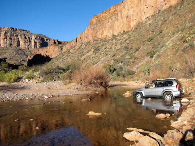
Now of course for many of you this axle deep little creek isn't worth a pic...but for us desert dwellers these are rare chances to dip a tire and have some fun. But in all seriousness these can be super dangerous for us as a flash flood moves brutally fast in these canyons.
salt%252520river%252520self%252520road%252520adventure-34.jpg


Now I have seen some strange things when out in the wilds...and some indicate how the human mind works. I would say that at some point there was concern about washouts on this shelf road. But either the money or the interest ran out as this patch of concrete was less than 100yds long...interesting.
salt%252520river%252520self%252520road%252520adventure-35.jpg


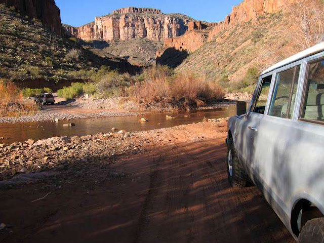
And on and upward we went. There was just more and more of this to enjoy, and we were having a blast.
salt%252520river%252520self%252520road%252520adventure-36.jpg


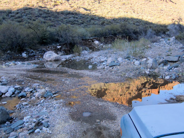
Well almost another water crossing, but again if you look at the rocks you can see that when the floods happen it is major force in action.
salt%252520river%252520self%252520road%252520adventure-37.jpg
 

1leglance

2007 Expedition Trophy Champion, Overland Certifie
And then we got to the Salt Banks Campground...well it had the best name and the saddest condition. We should have known when we started down some rough and rarely used 2 track but as always ya just gotta take a look.
salt%252520river%252520self%252520road%252520adventure-39.jpg


It was very pretty here and well named for the vertical white banks (they could be salt, who knows) but Waymon has spotted a nice bit of Second Camp that called to us and this place just wasn't worth hanging out. And of course nothing bad about running back through those water crossings :)
salt%252520river%252520self%252520road%252520adventure-40.jpg


This was are little bit of Second Camp and it was perfect. Well perfect in the sense of a great location, as long as you didn't touch the structure. If you look close you will see that each pole leans in a different direction. I figured with a bit of wind it would spiral it's way right to the ground :)
salt%252520river%252520self%252520road%252520adventure-41.jpg


Ya gotta love little details like this. I am not sure what the value is to having this info, but it is cool that someone put it here.
salt%252520river%252520self%252520road%252520adventure-42.jpg


Waymon got to work putting together his Kodiak Canvas Palace, and I of course tried not to make fun of his since I have a simple sleep inside the rig setup.
salt%252520river%252520self%252520road%252520adventure-43.jpg


And as I explored our campsite I once again noticed that no matter where you go in the southwest it seems Bud Light has been there before. Please don't think I am anti-beer or anti-Bud but ask around and you will find that Bud Light is the beer that gets left as trash in the desert more than any other.
salt%252520river%252520self%252520road%252520adventure-44.jpg
 

1leglance

2007 Expedition Trophy Champion, Overland Certifie
I took a little walk down to the water and looked back at camp...I liked it.
salt%252520river%252520self%252520road%252520adventure-45.jpg


Of course the river view was nice also and if the temps weren't so cold it would be fun to jump in and splash around a bit. Or dip a line and catch some dinner, then again I don't like fish so I would be catching someone else's dinner!
salt%252520river%252520self%252520road%252520adventure-46.jpg


Now this isn't just a cool pic of a tree that managed to grow around a rock. That is very nifty all by itself, but as an added bonus I got to use this stump as my camp chair for the evening. You see I like to keep my rig fully packed and ready to roll all the time. That is a great plan unless you clean out your rig like I did a few days before. Then you get to forget things like camp chairs :) Oh well the good Lord provides!
salt%252520river%252520self%252520road%252520adventure-47.jpg


And since you had a chance to laugh at my folly's I thought it would be good to post a pic of how Waymon dresses his dog :) In all honesty the temps were expected to be cold and Waymon cares about his Lexi lady dog. But PINK, it was funny in a good way.
salt%252520river%252520self%252520road%252520adventure-48.jpg


And that Kodiak Canvas Condo of his, well it was just as posh on the inside as out. Nothing like a Man Cave in the woods.
salt%252520river%252520self%252520road%252520adventure-49.jpg

salt%252520river%252520self%252520road%252520adventure-50.jpg
 

TexGX

Explorer
So I think this story has been a little one sided. Let me see if I can add something to it. This is one of those trips were you have passed by a road that look interesting and thougth, I would going to have to try that road. This is that trip. I had noticed the dirt road following along side the river the last time I crossed the Salt River. I never would have guessed what a great trip it would be.

Pay.jpg
Just to prove we did Pay(cell phone Pic)

Salt River 12-12 002.JPG
This is a pic of the view starting out.

Salt River 12-12 003.JPG
The funny thing about this Photo was just a few minutes before, I told Lance that the only thing that could make this better would be a river crossing. I know this is not much, but it was water. (The GX's manual says that I can cross water over 28 inches stock)

Salt River 12-12 005.JPG
Another amazing view

Salt River 12-12 016.JPG
This is Lexi, I am currently fostering her. I will say she is the best camp dog I have ever had. (I do not know if she will be leaving) She is a girl, freezing temps and the pink jacket was on sale. Enough said.

I will add more tomorrow.

TexGX
 
Last edited:

1leglance

2007 Expedition Trophy Champion, Overland Certifie
Ohhhhh don't my rig look ghetto beautiful cruising across the water like that :)
Nice pics and great to have you as another voice in the story Waymon.
attachment.php
 

1leglance

2007 Expedition Trophy Champion, Overland Certifie
Day 2 begins....
Yeah I know, all that and we only covered day 1, and really that was just a partial day as we didn't roll out of Phoenix until about 11am and then there was lunch in Globe, so you can imagine how happy we were to have enjoyed our little adventure up to this point. And it only got better.
Here is a map of Day 2, notice all those wiggles in the track, well if you zoomed in they really scribble a tale of shelf road madness. According to my Oziexplorer track log we rolled out of camp at 8:10am, went 107.5 miles (with all of it on dirt except a touch of pavement going into Young & a bit at the end going into camp) and we stopped for the day at 17:12. And we felt worn out after all the stress of keeping the tires on the trail. As you will soon see.
salt%252520river%252520to%252520roosevelt.jpg


I know I gave Waymon some ribbing in this thread about his tent of joy but I admit to a touch of glamping myself as my recent purchase of a Little Buddy tent heater was very welcome in the morning.
The day started just like the previous one ended, on a shelf road!
salt%252520river%252520self%252520road%252520adventure-51.jpg


With plenty more to go. I honestly knew we would be tracking a chunk of the river from looking over Google Earth but that isn't the same as driving it.
salt%252520river%252520self%252520road%252520adventure-52.jpg


I give the Tribe credit for having good signs out here that let you know how far to go before you get to anything other than wide open spaces.
salt%252520river%252520self%252520road%252520adventure-54.jpg


At last I figured we were heading up and out of the canyon so with a quick glance down at the Salt River & Salt Banks we gave the rigs some throttle and began our climb.
salt%252520river%252520self%252520road%252520adventure-55.jpg


Yep up we went and the promise of more cool stuff to see was looking good in the distance.
salt%252520river%252520self%252520road%252520adventure-56.jpg


There is a river back there somewhere, and lots of peaks all around. This is rugged country and I always wonder what it was like for the early folks to cross the area on horse or with wagons. Those were tough folks.
salt%252520river%252520self%252520road%252520adventure-59.jpg
 

1leglance

2007 Expedition Trophy Champion, Overland Certifie
But guess what? The shelf road is back, now we laughed a bit at this point in the morning but by the end of the day we were just plain beat up from driving on the edge.
salt%252520river%252520self%252520road%252520adventure-60.jpg


Of course there are always rewards to match the hazards and one of them was Rock Springs which is where water comes out of the Rocks (imagine that!) and collects right on the trail. These are the kinds of things that allowed those tough Native Americans to survive along with the early travelers who were smart enough to find such desert treasures.
salt%252520river%252520self%252520road%252520adventure-61.jpg
 

shortbus4x4

Expedition Leader
Nice write up and pictures.

Glad to see I am not the only one to wonder how people got around before the interstate system. Every time I drive over Donner on I80 I think the same thing about how did people get over this on horse and wagon with no roads, and here I sit crusing along at 65 with my A/C on.
 

loren85022

Explorer
Sounds like a good outing. The pink dog jacket on a hunting dog just seems like abuse :)

Lance, as you prolly know, driving shelfs with hand controls adds to the pucker factor. Never do you wish for 2 hands on the wheel more than when there's a plunge off your side.
 

TexGX

Explorer
Here is the rest of my pictures:

Salt River 12-12 010.JPG
The view as we make the turn away from the river.

Salt River 12-12 013.JPG
This was an amazing spot. It would have been the perfect place to cool off on a hot day. I wished I had brought my kayak as the area up stream look interesting.

Salt River 12-12 017.JPG
Lance crossing at the spot above

Salt River 12-12 018.JPG
Dead Cow

Salt River 12-12 022.JPG
Lance on the ridge line

Salt River 12-12 024.JPG
Leaving the Reservation

Lance is much more a picture taker then I am. It seemed that he stopped every mile to take a picture. I am guessing we could have shaved two hours off the trip if I had stolen the camera. He can finish up the trip pictures. I will say that this was an amazing trip. We traveled over some amazing country. I would break up the long day two with a lunch break. The road was mostly self road so there is not a lot of places to get out and walk around. Camp on day two overlooking the lake did not suck. This would be a trip that I would do again.
 

Papa

Observer
My morning coffee read was so good. Had to go back to our journal to remember driving hwy 60 in our motorhome in December '09 crossing the Salt River and eyeing the dirt road that ran alongside it. Next time we are in Arizona we'll have our Explorer and that road will be on our list. A fun report!
 

1leglance

2007 Expedition Trophy Champion, Overland Certifie
And Day 2 continues...

Again the signage was great for letting you know where you were and where to go play...and if it was up to me I would add a little bit about how Canyon Creek is super cool and Gleason Flat is an excellent group campsite..as you will soon see!
salt%252520river%252520self%252520road%252520adventure-63.jpg


But for the moment it was good to get out of the rigs and have a place to stretch our legs that didn't have an ugly drop off.
salt%252520river%252520self%252520road%252520adventure-64.jpg


Even as old and sad as this coral was it still looked to be in use. Matter of fact we saw quite a bit of hints that cattle ranching was still happening in the area.
salt%252520river%252520self%252520road%252520adventure-65.jpg


But hey what is this...more shelf road...and a bit of water down there. Ok this could be good!
salt%252520river%252520self%252520road%252520adventure-66.jpg


A little twist to the right, a bit of twist to the left and you will get to a most excellent swimming hole. When the temps are warmer than we had that is.
salt%252520river%252520self%252520road%252520adventure-68.jpg


This section of Canyon Creek was super cool and we could have easily spent an hour or two hiking around. If you have any kids with you this is a must play place.
salt%252520river%252520self%252520road%252520adventure-69.jpg
 

1leglance

2007 Expedition Trophy Champion, Overland Certifie
Waymon and Lexi had a good time getting up into the rocks. We really thought we heard a waterfall back in there but without jumping into the water for a swim it was tough to see far enough back into the canyon.
salt%252520river%252520self%252520road%252520adventure-70.jpg


The water seemed plenty deep at this point but the crossing was shallow enough to see the bottom.
salt%252520river%252520self%252520road%252520adventure-71.jpg


Would make a cool and refreshing place to play in the summer heat.
salt%252520river%252520self%252520road%252520adventure-72.jpg


Waymon in his Lexus/Prado made quick work of the water crossing and I motored across in the big bad Suburban shortly after. Yeah I know it ain't nothing to many of you but for us desert folks this is way cool.
salt%252520river%252520self%252520road%252520adventure-73.jpg


The only signs of others folks out here was a ranch we passed that required us to open/close a couple of gates. Always remember to leave a gate like you found it unless there is a sign telling you otherwise.
salt%252520river%252520self%252520road%252520adventure-75.jpg


What do you know we found the Salt River again, I thought for sure we were done with it.
salt%252520river%252520self%252520road%252520adventure-76.jpg


As we made our way down to check out Gleason Flat we came across a bumper & a bed frame...ok you make up the joke that goes with those 2 bits of history :)
salt%252520river%252520self%252520road%252520adventure-77.jpg


And there was some newer than old mine equipment just off the road. I often wonder with the rising prices of metals if folks won't fire these operations back up.
salt%252520river%252520self%252520road%252520adventure-78.jpg
 

1leglance

2007 Expedition Trophy Champion, Overland Certifie
Gleason Flat offers a nice place to get yourself wet and take a break.
salt%252520river%252520self%252520road%252520adventure-79.jpg


And plenty of room for a group camp. Matter of fact I think this is where I might camp if I was doing this as a weekend trip where I had left Phoenix at 8am instead of the 11am we happened to roll out.
salt%252520river%252520self%252520road%252520adventure-80.jpg


This is an overlook of Gleason Flat and according to the map you can get across the water to a road on the other side. I am not sure if that is the San Carlos Apache land or National Forest...so make sure you do your research before trying it out.
salt%252520river%252520self%252520road%252520adventure-81.jpg


But away we went as there was more trail calling us...and it was nice to get some wide space going on either side of the rigs.
salt%252520river%252520self%252520road%252520adventure-82.jpg


Soon we were off the Res and onto Tonto National Forest land. Cherry Creek is the canyon/creek/route we took north and it held some great sites of it's own.
salt%252520river%252520self%252520road%252520adventure-83.jpg

salt%252520river%252520self%252520road%252520adventure-84.jpg
 

1leglance

2007 Expedition Trophy Champion, Overland Certifie
So after we finally had the pleasure of NOT driving on shelf roads as we motored north along Cherry Creek, Waymon lets out another Whoop on the radio to let me know there was water crossing with a twist.
salt%252520river%252520self%252520road%252520adventure-91.jpg


We could run this one side by side as there were two routes across. I tried to get a pic to show our little duel but this was the best I could do with 1 arm out the window.
salt%252520river%252520self%252520road%252520adventure-92.jpg


Before long we were back on the Shelf Road Adventure...hey if you are getting tired of hearing about it imagine the never ending drive :)
salt%252520river%252520self%252520road%252520adventure-94.jpg


And we came to some hunters who were parked by this sign. At first I thought they were checking out the cliff dwellings but it turned out one of this had got a buck and was hiking across the canyon to skin/quarter/retrieve it. They were out in a very cool vintage Bronco that I wanted a pic of but thought it would look strange to have a 1 legged guy hop out of 1 chunk of old iron to snap a pic of another old iron...but then again maybe not.
salt%252520river%252520self%252520road%252520adventure-95.jpg


And guess what we got to do another mini water crossing. This one was the only one I was concerned about not due to depth but steepness as my Suburbasarus has a bit of a looooong hindend hanging out there. But all was well with no tail dragging.
salt%252520river%252520self%252520road%252520adventure-96.jpg


Of course there were plenty of these guys to remind you to enjoy the views but keep an eye on the trail. You could have a very bad day hitting one of these puppy's.
salt%252520river%252520self%252520road%252520adventure-97.jpg


I am always amazing in Arizona how we can mix up our vegetation from zone to zone as you transition from desert to mountains. Here was a patch of snow with pines around us and a cactus growing along the road.
salt%252520river%252520self%252520road%252520adventure-100.jpg
 

Forum statistics

Threads
188,850
Messages
2,910,004
Members
231,273
Latest member
Hairlesswookiee
Top
­