How would you outfit this custom LJ?

jscherb

Expedition Leader
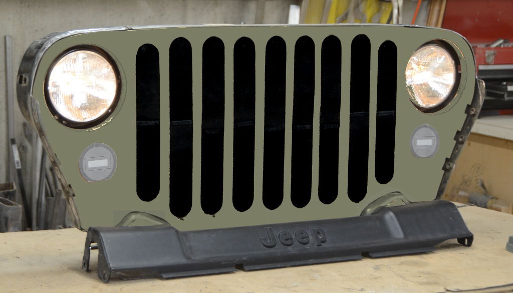
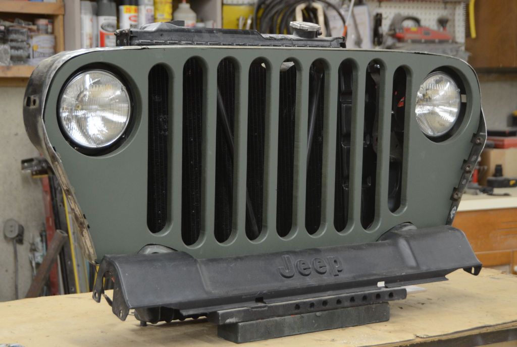
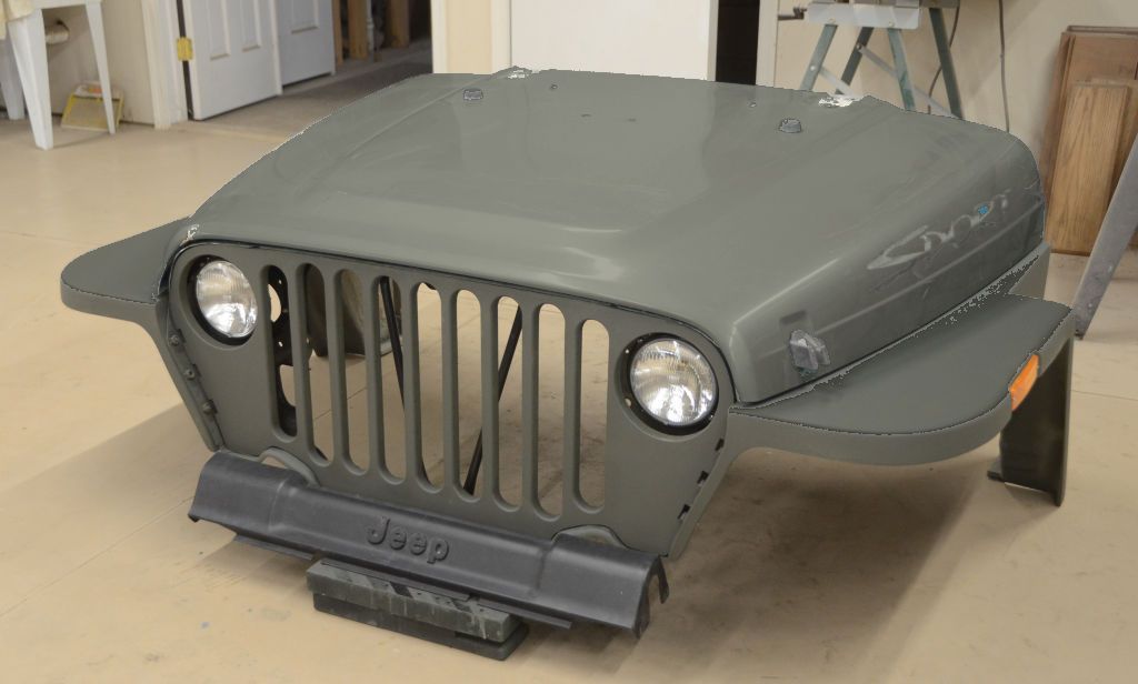
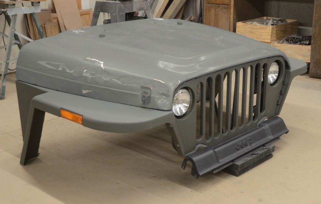
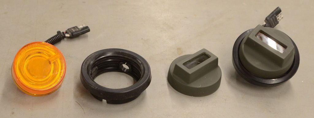
I made a few adjustments and I think this will be the final size and placement of the slots. I'll leave it on my workbench like this for a few days to decide if it's right and then I'll cut the slots. Also installed the headlight mounts and the headlights - the MB/GPW has smaller headlights than the later models so I had to change the mounts and the lights.

HeadlightInstalled3.jpg


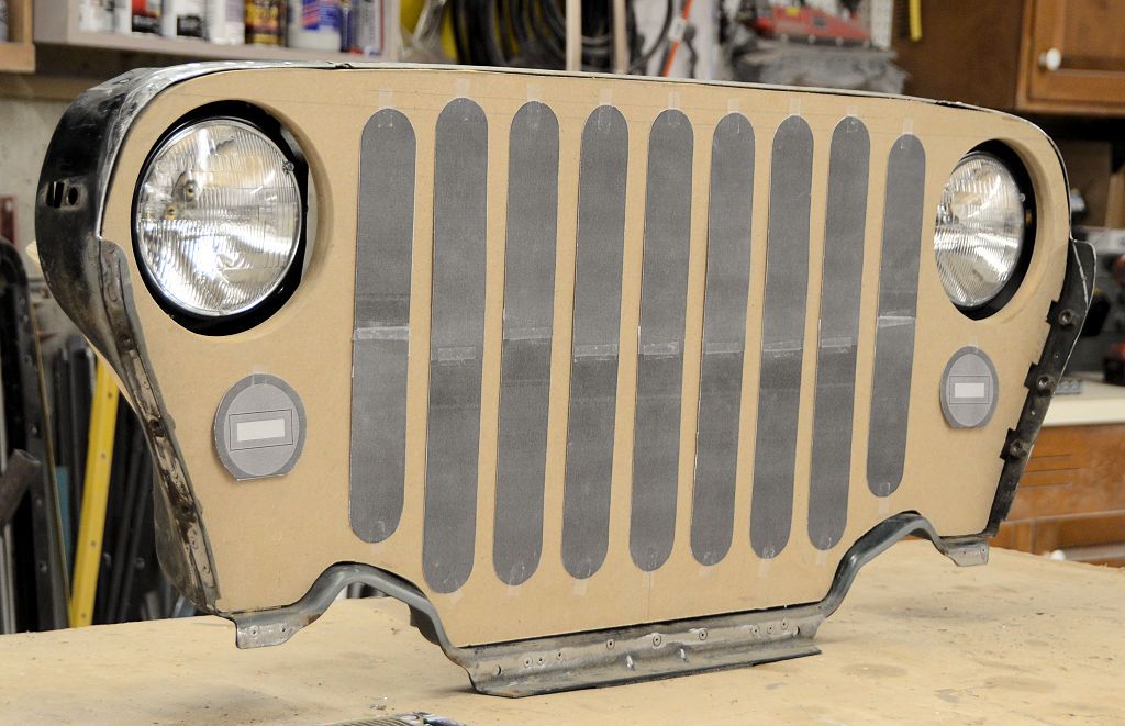
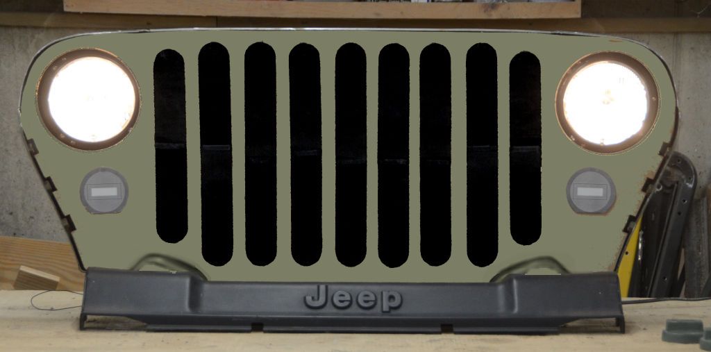
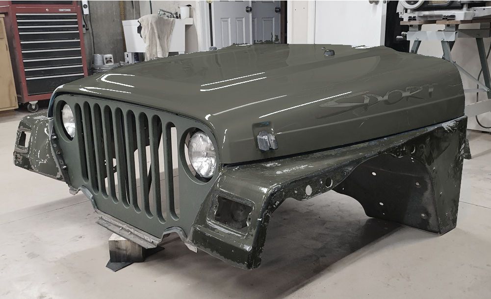
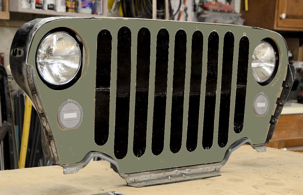
Colorized to give a better idea of what the final product will look like:

HeadlightInstalled3c.jpg
 

jscherb

Expedition Leader
I know youre going for MB turn signals but would modern LED driving lights fit in there as well?
I plan to make the mold without turn signals the same way I did the mold for the JK Style Grille for the JK, then temporary inserts can be put in the mold to support various types and sizes of turn signal. All three of these JL Style Grilles came out of the same mold - one doesn't have any turn signals, the one at lower left has recesses for stock JK turn signals, and the one at right has recesses for smaller 2 1/2" LED turn signals. Temporary inserts were put in the mold to make the latter two grilles. In this same way I'll be able to mold these MB/GPW grilles to suit pretty much any turn signal size or type.

TurnSignalOptions.jpg


Here's the current state of the project, I've made some final adjustments to the size of the slots, here are some new photos. I also powered up the headlights for these photos. Also powered up the headlights just for fun.

FinalSlots.jpg


Colorized:

FinalSlotsC1.jpg


FinalSlotsC2.jpg


I'll let this sit on the workbench for another day so I can study it to make sure it's correct and then I'll cut the slots.
 

jscherb

Expedition Leader
My MB/GPW Grille for the TJ is still a background project, but I have been making progress on it. I've cut the slots so now the basic grille panel made for the mold master is done.

SlotsCut2.jpg


SlotsCut2L(1).jpg


The TJ grille protrudes past the edge of the hood but on the original MB/GPW the hood overhangs the grille so I made this grille so it sits slightly behin the front edge of the hood.

Mocked up with factory fenders:

MasterTest1a.jpg


Same thing colorized to give a little better idea of how the end product will look:

MasterTest1c.jpg


And with flat fenders:

MasterTest2c1.jpg


MasterTest2c2.jpg


I also molded lens covers for LED lights for a modern version of the original MB/GPW marker lights:

BezelsDone.jpg


There's a bit more work to do before I can make the mold but it is moving along. Also it's a low priority "art project", by which I mean I don't intend to actually use the end result on any of my Jeeps - I'm just doing the project because it seemed like an interesting design challenge :).
 

jscherb

Expedition Leader
I posted in my JKU thread about the preproduction Compressor Bags that Overland Outfitters sent me to verify and test; they also sent me their preproduction TJ/LJ Seat Back Molle/Zip & Go/Grab & Go bands and since those don't have anything to do with the JKU I'm posting them here. They're made of nice leather with some brown webbing accents and an embossed leather emblem on the front. One is pictured below with a military surplus Molle ammo pouch. It also supports Grab & Go/Tool Belt Clip pouches and Zip & Go bags like the ones Quadratec asked me to design for their Anniversary Jeep.

TJLJSeatBandSample.jpg


TJLJSeatBandSample5.jpg


I mentioned the Zip & Go Bags in the Quadratec Anniversary Jeep; those bags work great hanging on these bands in the TJ too...

AsFeaturedIn.jpg


LJZipAndGo1024.jpg
 

jscherb

Expedition Leader
Trying out the new Cool Bag insulated drink/snack bag on the LJ seats.

CoolBagIIOnLJ1.jpg


I've got two Zip & Go attachment points on the LJ seats, in the next photo it's hanging on the upper one around the headrest portion of the seat.

CoolBagIIOnLJ2.jpg


CoolBagIIOnLJ3.jpg
 

jscherb

Expedition Leader
Spent the day today in the LJ exploring the east side of the old railroad route over Rollins Pass in Colorado. The route was obsoleted in 1928 when the Moffat Tunnel opened, which eliminated about 30 miles of treacherous trackage over 11,660' Rollins Pass and replaced it with a 6.2-mile long tunnel under the Continental Divide (https://en.wikipedia.org/wiki/Moffat_Tunnel) and since the 50's most of the old railroad right of way has been a trail. It's a fairly easy but uncomfortable trail covered with 6"+ embedded rocks and 9"+ deep holes for a large part of the way, but there are no technical challenges.

The route is divided into two separate parts, you can't go completely across - there is a short tunnel at the summit that's been closed for some years now, so you can approach the summit from the east and the west but you can't go all the way across through. Back when the right of way was first opened as a trail (and the tunnel was open), the Forest Service published this:

RollinsPassMoffatRoad.jpg


Approaching Needle's Eye Tunnel from the east. It's the black dot roughly in the center of the photo. The Jeep is at about 11,500 elevation.

NeedlesEyeApproach.jpg


The tunnel is barricaded at both ends but I'm tall enough to take a photo over the barricade. You can see the barricade at the other end in the photo.

NeedlesEyeTunnel.jpg


The plan is to approach the tunnel from the west side tomorrow, but that's dependent on the weather. Rain is forecast all day. Today it started to rain just as we were beginning our descent from the tunnel. It rained the rest of the afternoon. The trail didn't get slick but all the potholes filled quickly with water. This photo was taken on the way down, about a mile from where the trail is closed before the tunnel.

LongCut.jpg
 

zgfiredude

Active member
Welcome back to Colorado! Have you seen (most likely yes) the Glenwood Canyon closure due to mud slides? I'm just west of Glenwood Springs, holler if your travels bring you anywhere close.
 

jscherb

Expedition Leader
Welcome back to Colorado! Have you seen (most likely yes) the Glenwood Canyon closure due to mud slides? I'm just west of Glenwood Springs, holler if your travels bring you anywhere close.
Yes, I've been watching the Colorado DOT site (https://cotrip.org/travelAlerts.htm#?roadId=) for updates on I-70 through the canyon because we're hoping to spend a few days at the Hot Springs Lodge after we finish the trails. Might have to take the long way around (Breckenridge/Leadville/Granite/Aspen/Carbondale) if we decide to go, more than 2 hours longer than getting there via I-70. Or could do Hagerman Pass trail/Frying Pan Road from Leadville to Basalt if we're feeling more adventurous.

Right now monitoring the weather here in Winter Park, planning to do the west side of Rollins Pass today, weather permitting. Rain yesterday didn't make the east side trail unsafe, so as long as bad thunderstorms don't seem likely we'll probably do the trail.
 
Last edited:

BritKLR

Kapitis Indagatoris
Welcome to Colorado! Rollins Pass has a colorful history and we're still lobbying Boulder County to re-open the route. Did you make it up the road from Rollinsville to Nederland? Would've enjoyed grabbing a coffee or showing you some more local trails! Cheers and be safe out west, the Colorado Monsoon is in full effect and has caused some challenging trail conditions!
 

jscherb

Expedition Leader
Welcome to Colorado! Rollins Pass has a colorful history and we're still lobbying Boulder County to re-open the route. Did you make it up the road from Rollinsville to Nederland? Would've enjoyed grabbing a coffee or showing you some more local trails! Cheers and be safe out west, the Colorado Monsoon is in full effect and has caused some challenging trail conditions!
We approached Rollins Pass East from Black Hawk and didn't get up to Nederland. Monsoon so far isn't defeating us :). The rain yesterday on Rollins Pass East didn't really affect the driveability of the trail and didn't start until we were on our way out, so it didn't prevent us from enjoying ourselves. Today the rain didn't start until the last two miles on the way out of the west trail so no problem today either. Lucky so far.

We've been missing Colorado; for the past decade we've been coming out west for trail expeditions every year at least once, sometimes twice a year or more. Missed last year due to the pandemic and this year is very busy but we had to squeeze in at least a short trip out here to enjoy Colorado.
 

jscherb

Expedition Leader
Today we did the west side of Rollins Pass. The trail isn't as rough and uncomfortable as the east side, but the last two miles to the Needles Eye tunnel is pretty rough. Lots of rain was forecast today but luckily it held off until the last two miles on our way out. The west side is more interesting for railroad buffs since there are several relics left over from when the trail was a railroad line, like the Rifle Sight Notch trestle:

RifleSightNotch.jpg


Not having been used in 93 years, it's not in very good shape.

RifleSightNotch2.jpg


Clouds closed in at the summit, and at one point visibility was down to less than 50 feet.

RollinsClouds.jpg


The last 2 miles to the west side of Needles Eye Tunnel is a very rough trail and I did about 1.5 miles of it and then decided to walk the last half mile - visibility was just too low for safety.

The west side of the Needles Eye Tunnel, I visited the east side yesterday:

NeedlesEyeTunnelWest.jpg


From the tunnel, it's about a mile hike to the Devil's Slide Trestles. These are a real engineering feat, I haven't figured out how they could build these hanging on the side of the mountain. Clouds prevented great photos:

DevilsSlide1.jpg


But to illustrate the engineering feat, here's a photo I found online:

DevilsSlide2.jpg


May do Hagerman Pass tomorrow but haven't finalized our plans yet due to the mudslides on I-70.
 

zgfiredude

Active member
Leadville to Hagerman down to Basalt.....if wanting to head back East, look at your maps for "Cottonwood Pass" (there are several in Colorado, LOL....from just north of Basalt to Gypsum. That way you'll stay on the East side of the Glenwood Canyon disaster. That Cottonwood Pass is a dirt road that turns to chip and seal closer to Gypsum. It will have some local traffic on it as a locally known "work around", but it should be just fine. Or, Independence Pass via Aspen, but the Google Map faithful will be there from the I70 closure, so likely it will be NUTS!
 

jscherb

Expedition Leader
Leadville to Hagerman down to Basalt.....if wanting to head back East, look at your maps for "Cottonwood Pass" (there are several in Colorado, LOL....from just north of Basalt to Gypsum. That way you'll stay on the East side of the Glenwood Canyon disaster. That Cottonwood Pass is a dirt road that turns to chip and seal closer to Gypsum. It will have some local traffic on it as a locally known "work around", but it should be just fine. Or, Independence Pass via Aspen, but the Google Map faithful will be there from the I70 closure, so likely it will be NUTS!
Thanks for the helpful info! If we get to Glenwood we'd be leaving on Tuesday so if I-70 isn't open then I was thinking maybe Cottonwood Pass would be the best way east. Hopefully the rains have left that safe.

Today I'm thinking Hagerman Pass but the forecast for Leadville is rain from 11am on, so we'll make a decision when we get to Leadville whether to stay on pavement or go overland.

Checked my photo archives... the last time I did Hagerman Pass was 5 years and 3 days ago (July 28, 2016):

HagermanSnowbank(1).jpg


I wonder how much snow is up there today?

HagermanSummit(1).jpg
 
Last edited:

Forum statistics

Threads
185,541
Messages
2,875,681
Members
224,922
Latest member
Randy Towles
Top