Yetti’s Pacific North West Exploration & Expeditions Picture heavy

Pacific Northwest yetti

Expedition Medic
Flagstaff, FEMA Deployment team. Those pictured were directly my reports. Was a good team. They were all new EMT,s or Medics.

I also had some 68w, 18D, that were assigned to my team. And sometimes some FEMA DMAT staff, or County Health Dept Nurses ( Not Pictured)

March 17th 2021

IMG_3488_20210317_131735.jpg

Of course 6ft apart, ish.
IMG_3489_20210317_131735.jpg
 

Pacific Northwest yetti

Expedition Medic
April of 2021.


Walnut Canyon, Outside flagstaff. Cliff Dwellings


Pretty cool place. Random pictures, as the vast majority were deleted after the breakup.

I snuck away one night of camping (with cell service of course) On a Saturday afternoon, and Sunday Night.
afd73ecb5703689eb0ced2acbe527d03.jpg
26c98bcf3fcb66e296483c9d84dd6358.jpg
cec07f8f88a2cc6d2b62500ed467e2c9.jpg
7326514b687433bb9cd57a130ef81ae1.jpg
d7c80317495fe0b1d2c14831d2d72c68.jpg
8e501435e9ae74eec119177ce45726ab.jpg
 
Last edited:

Pacific Northwest yetti

Expedition Medic
Guam,


November of 2021

I use a color coded system on google maps to track where I have been, and places I want to visit. This is a screen shot of Guam. The Turquoise designated places I visited. Of course not everyplace I visited is shown, just ones I decided, or remembered to mark down.

The 3A, 9 and Yigo area is primarily military basis and off limits. The base has some pretty awesome private beaches. If you are able to get in. I had friends who were stationed here at various times, and they gave me a solid list of things to check out. However, at my time of visit no contacts on base.


Capture Guam.PNG
 
Last edited:

Pacific Northwest yetti

Expedition Medic
Present day, Jan 2023


I'm not sure what this poor cone did.... But it’s looking bleak.

Saw this rig taking the dog out, it’s a UPRR rail rig of some sort. I don't know its purpose though. Almost looks like a jet engine weed burner.

4133fb8ca3e9eb8b1c685026c76fd629.jpg


Sent from my almost BlackBerry pocket tool. From somewhere remote. Happy Tails & Safe Travels
 
Last edited:

Pacific Northwest yetti

Expedition Medic
November, 2021

An Island Touched by war, after war, after war...


About Fort Nuestra Señora de la Soledad
Park located on the remains of a 19th-century Spanish fort, named for Our Lady of Solitude.
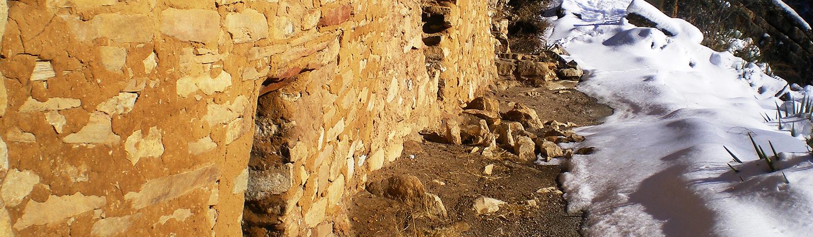
Fort Nuestra Señora de la Soledåd, or Fort Soledad, the last of four Spanish fortifications built in the village of Humåtak/Umatac, is located atop a steep bluff called Chalan Aniti, or Path of the Ancestors. The fort provides a superior view of the village, the bay, the rugged coastline, and the imposing southern mountain range. The fort was constructed to strengthen the defenses of Guam’s most prominent Spanish-era bay.

Humåtak Bay served as an important supply station for ships crossing the vast Pacific Ocean during the era of the Acapulco-Manila galleon trade (1565 – 1815). With an increasing number of non-Spanish ships sailing through the Pacific in the last half of the eighteenth century, it became necessary to protect Spanish interests on the island. Fort Soledad helped to strengthen flaws of the other forts built along Humåtak’s coastline. Fort Santo Angel, located on the opposite side of the bay, was built in 1756 and had been badly damaged from years of pounding waves. Governor Alexandro Parreño (1806 – 1812) determined that the foundation supporting the fort was unsafe and had the fort dismantled. Fort San Jose, despite being newly constructed in 1805, was positioned too far north to adequately protect the entrance of the bay.

Although Governor Vicente Blanco (1802 – 1806) had described artillery that had been mounted on Chalan Aniti as early as 1803, it was not until some time during Parreño’s administration that the fort’s construction was completed and officially named Fort Nuestra Señora de la Soledåd, Our Lady of Solitude. In a document dated 1810, Parreño described the features of the newly built fort, which included a barbette, a guardroom for officers and troops, and an arsenal storeroom.

The fort faced the sea and was elevated eighty varas, or approximately 224 feet, above the bay. The esplanade was paved with flagged coral stones and was partially surrounded by a low parapet constructed of mampostería, stone and mortar. The fort could accommodate seven cannons that were to be fired on a fixed line over the parapet.

Unfortunately for Spain, the Mexican Revolution brought an end to the galleon trade. By 1815, the last Cavite ship returned to the Philippines from Acapulco, signifying the end of an era. Spain no longer had the means to maintain Guam’s fortifications and Fort Soledad was allowed to deteriorate. Treasure hunters expedited the fort’s destruction as they pulled up the floors in search of the fortune rumored to be buried at the site. After the Second World War, souvenir hunters continued to pillage the fort. The government of Guam, however, stopped the complete destruction of the fort and continues to protect the site as a public park.

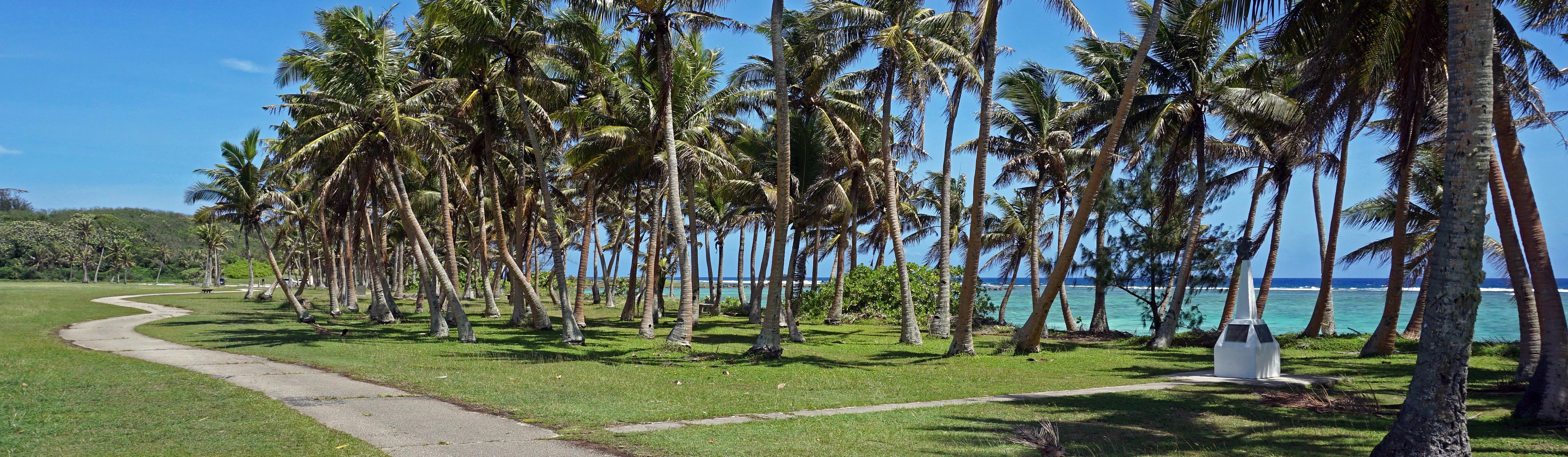
The fort’s sentry post, overlooking the picturesque bay, has become an icon of the island’s beauty and the days of the Spanish Galleon trade. Today, the park is one of the most visited places in southern Guam. In the mid 1990s restoration efforts were made to the area’s stonework and more recently several beautification projects have been undertaken by the community to improve the historic landmark.

By Daryl A. Haun

For further reading
Beaty, Janice J. Discovering Guam: A Guide to its Towns, Trails and Tenants. Tokyo: Tokyo News Service, 1967.

Degadillo, Yolanda, Thomas B. McGrath, SJ, and Felicia Plaza, MMB. Spanish Forts of Guam. MARC Publications Series 7. Mangilao: Richard F. Taitano Micronesian Area Research Center, University of Guam, 1979.

Driver, Marjorie G., and Omaira Brunal-Perry. Architectural Sketches of the Spanish Era Forts of Guam: From the Holdings of the Servicio Historico Militar, Madrid. MARC Educational Series no. 17. Mangilao: Richard F. Taitano Micronesian Area Research Center, University of Guam, 1994.

Guam Department of Parks and Recreation. “Guam State Historic Preservation Office.”

:

It was a beautiful day, still of course hot and Muggy. And getting used to the 17hr time jump was taking some time.


To touch and feel the history in the old stone was pretty cool. There was a gentleman selling fresh coconut. He was a character and was living out of his rig with his family. They were cheap and good. He explained the history, how the chomoro peoples did it, and what to look for when picking one out. They also had a super friendly dog running about. Said he goes through about 50/day. This was my first time ever having any, or one like this. I don’t usually like the taste, this was not close to what I think of when I think of the taste.


1636958434062.jpg1636958439021.jpg1636958459862.jpg1636958483580.jpg1636958685392.jpgIMG_20211111_1606196.jpg
Twas a good day,
 
Last edited:

Pacific Northwest yetti

Expedition Medic
November, 11,2021

War in the Pacific National Historic Park


War in the Pacific National Historical Park was established to commemorate the bravery and sacrifice of those participating in the campaigns of the Pacific Theater of World War II and to conserve and interpret outstanding natural, scenic, and historic values and objects of the island of Guam.


These beautiful views, were surrounded by a mine field on one side, and warning for Fire Ants on the other...


Down not far from there, was the Umatac bridge...

From the bay to the right, you can see part of the fort. We had a good time walking around this little area, including an old school, and hospital. Some kids and their pet cow. As well as some local high school kids hanging out with their car and playing music. A lot of the pics from this have been since deleted as they were a bunch of sappy couple shots, or shots of the GF.

There are still some I have resized to the smallest that windows let me in the photos app and it’s still blocking it......oh expo...


IMG_20211111_1613536.jpgIMG_20211111_1626396.jpgIMG_20211111_1717050.jpg

Not being uploaded, a sign of the War In the Pacific park, explaining what old land mines look like, a map of the boundary area.
And some large guns mounted overlooking the small beach.
 
Last edited:

Pacific Northwest yetti

Expedition Medic
Now changing my tactics, Ill upload what it will allow me to do. After the resize to small. And fill in the blanks.

Guam, November 2021

These little trucks, were everywhere. The US sells them off base when they retire them. So there are a lot around.

Never far from a sign of battle, or church.

beautiful beaches, and memorials


1636696058703.jpg1636958303999.jpgIMG_20211111_1656352.jpgIMG_20211113_1018448.jpgIMG_20211114_1648456.jpgIMG_20211114_1648505.jpgIMG_20211115_1341527.jpg
 
Last edited:

Pacific Northwest yetti

Expedition Medic
November, 14, 2021 Guam.


Puntan Dos Amantes (Two Lover’s Point)

What do you do when you are (were) a couple in love? You go to two lovers point, overlooking the bay you’ve been snorkeling in every night and morning.

The foreshadowing...

Two Lovers Point is prominent cape and seaside cliff in Tamuning, Guam, that overlooks northern Tumon Bay and the Philippine Sea. One of four National Natural Landmarks on Guam, it is closely associated with the folktale of two doomed lovers and is a major tourist attraction

1636961957437.jpg1636961964989.jpgIMG_20211114_1743531.jpgIMG_20211114_1807183.jpg

It was a good place to watch the sunset. We followed up with some great burgers, and night snorkeling. ( Stax, the burger place was good enough, we went multiple times. which was uncommon for us when traveling) We could call ahead, and pick up. Then walk through the park across the road to the little statue of liberty and eat. This night we drove to a different bay close to the hotel to Snorkel. (Ypao Beach)


The weather was weird this night, and the bay was empty. We ended up leaving after only an hour or so of snorkeling, as we both got a weird feeling about being out there. There was a storm rolling in, and the moon was not showing up for us, the water and currents were doing weird things. I am super new, and She had only been doing it a month. So we choose to trust our guts.
 
Last edited:

Pacific Northwest yetti

Expedition Medic
Guam, November 2021

That beautiful beach, that had land mines and fire ants? This was the beach view......
That concrete box in the surf showed signs of something big and heavy being mounted to it

Jungles mean big bugs, and all sorts of critters
1636977919905.jpg
IMG_20211115_1146127.jpgIMG_20211115_1147471.jpgIMG_20211115_1147554.jpgIMG_20211115_1322281.jpg

I also tried to upload some pictures,

this Guam Natl wildlife refuge was closed. It was surrounded by a massive, and patrolled fence. Dog teams, as well as what looked like 4 man crews, in a skeleton ZR2. Was next to a Marine Weapons Range.
 
Last edited:

Pacific Northwest yetti

Expedition Medic
November, 2021 Guam


Hike to Pagat Cave.


I’m sure it’s no surprise I spent my days while the GF was working, hiking and exploring. It was a good system, picking her up, dropping off, and bringing lunch in-between.


It was a steep trail, and a few others on their way into the cave. The cave itself was busy, and I was solo....soo I continued on to the end and the view, and natural bridge from the coast. It was hot, and muggy. The cave is a lot like a Cenote you’d see in Mexico and would be a fun one to do.


Getting soaked after 20 mins of hiking. There was a good but if steep scrambling. I’ll try and find the route saved from my watch and upload it as well.


The journey to Pagat Caves is not a very long hike, just over a mile, but it is fairly steep in places and drops down 400 feet in elevation

The Chamorro village of Pagat existed on the shelf overlooking the Pacific Ocean. Evidence to date indicates the site was occupied from before Christ to sometime after 1700. There are few artifacts of the early Chamorro village that existed there.


Edit Pics**

Bummer, those were some pretty ones that its blocking now.

IMG_20211115_1136393.jpgIMG_20211115_1139366.jpgCapture.PNG
 
Last edited:

Pacific Northwest yetti

Expedition Medic
I have a few more to share when it comes to Guam/ Despite resizing to.25mp and them all originally being taken from a Blackberry Key 2, its not allowing me to upload anymore. Ill try to find a work around for the few I have left, that are shareable.

I have a river cruise, to a recreation of a local chomoro village. On Sunday Nov 14th. It was touristy but they did a great job, with lots of history, lunch, interactive and also allowing us to try some of the skills they were teaching us.


I would recomend it, if you ever find yourself in the area. We had a great time.


Precolonial society in the Marianas was based on a caste system, Chamori being the name of the ruling, highest caste.


And the hike of death to Tarzan Falls. I did make it to some falls....just not Tarzan falls, no wonder i saw no one else around. I broke my flip flops on the scramble back up. But was lucky enough to find an old shoe lace and was able to fix them for the last mile. I am pretty hard on my combat flipflops but they make a great product.


I started on the correct trail head, I was never lost. However, it was all rock/ scree, with 4x4 trails. So I picked a route and headed down toward where I figured the falls would be.
It was not a planned hike, saw it on the drive by kind of thing after dropping the GF off for the day. I take a quick look at the google reviews, and sign post in the parking area. I should of headed North, Instead I followed the steeper draw and faint tracks East.

Yes, I have GPS on my phone, and had service. With at least three separate mapping apps Suunto, GAIA,Back Country Navigator, I even had Guam downloaded on BCN, and Earthmate. Not to mention Google Maps. I did let the GF know where I was, and the plan...and kept her updated with geo tagged pics once at the bottom. She tried to follow my route later and did not make it, turning around. She of course scolded me for being dumb that day.

Cold water never felt so good, and I had the place to myself!! I stripped down to boxers and just soaked. I made sure to sip my water on the way down as I only brought the one bottle, I was out however before I made it back to the top. It was only a few miles.... I did not even record the route with my watch until the way back up. Slow and steady. I soaked all my clothes with the river water for the climb back up. As well as topped my water bottle with some probable fine river water. " filtered" through my shirt.

I was quite dehydrated when I made it back to the rental car, sipping water I had in there. My vitals were a little hinky the rest of the day, I was dancing with heat stroke, headaches, blurred vision. And had stopped sweating when the car came into view. Truth be told, i was probably half hour away from a serious issue. The rest of the day was easy, in the AC of the hotel. With some light snacks and sipping water. I started an IV on myself when she got back after work and was much better the next day. The next day was the river cruise, so it was relaxing and the GF did all the driving.

As someone who specializes, and is extremely experienced in remote medicine and risk management, I made a bad choice at the time. It’s often the ones who know better, or are " professionals" who get into trouble.


Screenshot_20230209-144220.pngScreenshot_20230209-144225.pngScreenshot_20230209-144251.pngScreenshot_20230209-144323.png
 
Last edited:

Pacific Northwest yetti

Expedition Medic
Guam, November, 2021

Underwater world Aquarium

We made friends, the aquarium was cool. Although I almost always check the out If I am any where close.

The big Groupers always make me smile. Romantic stroll through the underwater rooms

IMG_20211114_1107556.jpgIMG_20211114_1108068.jpgIMG_20211114_1109536.jpgIMG_20211114_1109575.jpgIMG_20211114_1116358.jpgIMG_20211114_1119034.jpgIMG_20211114_1119081.jpgIMG_20211114_1119263.jpg


Pacific Northwest yetti

Expedition Medic
Present day,

On Feb, 2, 2023 we lost a great guy who was rendering Aid in Ukraine. I’ll just copy what I wrote on the post


" Pete was a great guy. He lived his life, and his passion to be a better human, improving the world we lived in with his every step. He was the best of us. Rest in peace, we will continue on"

Pete was the founder of Global Response Medicine.

I can honestly say the world is a darker place without Pete.

and a Link from the press release


Last edited:

Pacific Northwest yetti

Expedition Medic
Sunday November 14 2021, Guam.

River cruise, images I was able to salvage. I resized on computer, email to myself and uploaded from the app.... Good thing that's not the normal process

46b098bffd292f469fda407b0530e0e4.jpg
6584c2a4a5750381fa17f97b8723ccdd.jpg
a08a4513178226f1ed2abc3063069631.jpg
34f510a8e6276d81462ab1e46d444fce.jpg


Sent from my almost BlackBerry pocket tool. From somewhere remote. Happy Tails & Safe Travels
 
Last edited:

Pacific Northwest yetti

Expedition Medic
November, 2021 Guam
Talofofo falls, and LoveLand.

To get to the lower section, there is a tiny, hot smelly tram. You can almost see the cable in the falls picture here.

Until I find a way to attatch these normally, this will serve as a place holder. It was a pretty place, albiet slightly weird mix of stuff...Capture The Falls-loveland.PNG
 

Forum statistics

Threads
185,795
Messages
2,878,272
Members
225,352
Latest member
ritabooke
Top