Rae Lakes Loop, Kings Canyon National Park

defrag4

Road Warrior
Rae Lakes Loop
July 3-7

On a recent trip back to my homestate of Florida I was kayak fishing the beautiful Mosquito Lagoon with an old friend of mine. Passing the time in converstation I mentioned to

him that if he came out to visit me in California I would "blow his mind" with an adventure of epic proportions. As I imagined he would, my friend (Doug) instanstly replied,

"When should I show up?"

14334_199216322116_717797116_3633471_7277418_n.jpg


The game was afoot. I told him July would be a great month to show up. I was planning on the Sierras being fairly melted off by then and hoping to show him the amazing high

sierras.

Little did I imagine that while I was enjoying a 85F day on the sunny flats of FL, the mountains back home were getting hit with record breaking amounts of snowfall.

nsm_swe_2011032805_western_coastal1.jpg


Around May I started trip planning. I was oringinally planning on doing the BackPacker Magazine High Sierra Loop, a nice 5-6 day adventure along the peaks surrounding Yosemite.

During the research for this route I stumbled upon a route I had been eyeballing ever since I first moved out to CA and got into backpacking. The Rae Lakes Loop. I first read

about this loop on Kevin Gong's site, highly recommended well organized site. http://kevingong.com/Hiking/RaeLakesLoop.html

Rae Lakes Loop is 50 mile long loop that climbs from 5035Ft at Roads End (trailhead) all the way up to ~12,000ft at the top of Glen Pass. It is considered one of the most scenic

backpackinig trips in all of the Sierras. It surely stood up to the hype. Bears are also very active along this loop and bear canisters are mandatory gear.

349519_f520.jpg


Normally in July the snow has mainly melted off and this hike does not pose any real techincal threats aside from the elevation climb. However this was not a normal year, snow

was still reported to be holding anywhere above 8000ft, we were headed to 12,000Ft! I scoured the internet for any information I could find, unforuntaley there was very little

out there. A few hikers had made it to Glen Pass and turned around, high swift river crossings and deep snow seemed to be the only info I could glean. Undeterred I decided to

stick with our plans, knowing if things got too crazy we could always turn around and head back the way we came.

After wrestling with the massive bastards of canisters that the park rents to hikers I decided to purchase my own. I picked up 2 Bare Boxer canisters which luckily arrived 2

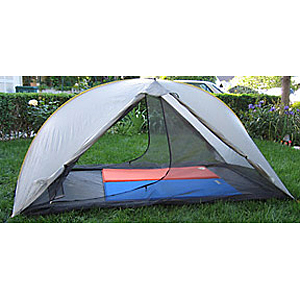
days before our trip. I also wanted to trim down my baseweight before this hike, I ditched my awesome Marmot Limelight 2P (~5lb) in favor a lightweight Tarptent DoubleRainbow

(~2.5lb)

271061_10150226650567117_717797116_7844207_3272003_n.jpg


double-rainbow-300x300.jpg


Dougs plane landed at SFO around 945AM on July 2nd, 2011. I scooped him up and we headed back to my place in Orinda for some last minute packing and weight-culling of Dougs

pack. I think we trimmed at least 5Lbs of gear out. After the packs were set we loaded up the Jeep and hit the road.

269008_10150236884587117_717797116_7960803_7857827_n.jpg


Doug was getting a good tour of the wild and wacky climates of Northen California as we left Aiport (75F), headed into SF (55F), headed to Orinda (85F), then eventually made it

to Fresno (106F!) then all the way up to Kings Canyon (75F). ..And he thought I was crazy when I told him to pack for everything from freezing snow temps to scorching desert

blazes.

269651_10150234169417117_717797116_7928791_3256735_n.jpg


We wound up the 180 crossing the central valley before heading up into the Sierra mountains. Eventually arriving at the Ranger station for Kings Canyon.

269397_10150234162812117_717797116_7928705_3442188_n.jpg


I finally broke down and

purchased an "America the Beautiful" annual pass for the all US park systems for $80. I figure I have spent at least $100+ or so in the past months on various park admission. It

was a painless process, just pay for it and receive the card. Highly recommended if you spend as much time as we do bouncing around our Nations parks.


2011Annual.jpg


The day was getting late as we wound our way up the mountain and eventually back down Kings Canyon headed toward Cedar Grove. The road turned from deep woods into a gorgeous

deep canyon lined with high sierra peaks, the sunset lighting was perfect, we pulled over and took a few quick snaps before heading further into the canyon.

264611_10150234162837117_717797116_7928706_5826033_n.jpg


268685_10150234169442117_717797116_7928793_1284646_n.jpg


270352_10150234164202117_717797116_7928746_4006616_n.jpg


Knowing we werent going to make it to the trailhead in time to hike to a campspot before nightfall we started to scope out some of the "established" campgrounds. Well good luck

trying to find a campspot on 4th of July weekend. Every single campsite was full to the gills with weekend warriors, BBQ grills, and boomboxes. No thanks.

As we conitnued our search for a campsite I spotted a bear meandering through the woods from the car. We flipped a quick Uturn and jumped out to snap a few pictures. It was a

momma bear and her 2 cubs. Unforutantely the sun was going down and they were too far away for a flash shot.

267469_10150234162857117_717797116_7928707_199512_n.jpg
 
Last edited:

defrag4

Road Warrior
I followed them for a bit and noticed they were making a beeline up towards the road and looked as if they were planning to cross. Thinking this would be the perfect time for a photo-op I stood right in the middle of the road and waited. Sure

enough up come the bears to the roads edge, Mom bear went to cross, when out of NOWHERE a car comes screaming down the road. I swear to God this guy did not slow down or brake

at all, even with a man and a damn bear standing in the middle of the street. I freaked out thinking he was going to plow the bear right in front of me. Somehow he managed to

miss the bear and just kept right on going. Now I am standing in the middle of the street, Mom on one side of the street, 2 cubs on the other. This is a bad situation. I took

about 1/4 of second before I turned tail and hauled *** doing the 100 yard dash in .0002 seconds. I was planning on swan diving into the down window of the Jeep however a quick running glance over the shoulder showed that would not be necessary as the cubs were peacefully crossing the street to join Mom. Back

in the car after calming down a bit I started to look through my camera to see if I got any decent bear pics, too my suprise I found this one which I guess I snapped right as

this ******* almost hit this bear.

270214_10150234162872117_717797116_7928708_6730749_n.jpg


Looks like everyone is OK

270372_10150234162892117_717797116_7928709_264697_n.jpg


We found a safe spot on the side of the road to park and hiked down a bit to a nice flat area near a small side-stream of the Kings River.

262000_10150234162922117_717797116_7928710_2765699_n.jpg

268969_10150234162947117_717797116_7928711_621614_n.jpg


Woke up and broke down camp, headed down to the Roads End station and grabbed our permit. We were on the trail around 9AM. I encountered a hiker who was coming out of the trail.

He said streams were very high, some thigh to waist deep. Snow was also very deep and slushy. He looked exhausted. He was also equipped with cramp-ons and an iceaxe. 2 pieces of

equipment we did not bring. Hmmm... Well lets cross that bridge when we get there.

Heading up the Paradise valley trail we mingled with tons of day hikers as I expected, it is 4th of July weekend after all. The trail sticks close to the Kings River which was

RAGING with all the snowmelt and apparently a recent rain (oh boy!)

270607_10150234169597117_717797116_7928798_2247327_n.jpg

264272_10150234169672117_717797116_7928800_3274069_n.jpg


We eventually made it up to Mist Falls and stopped for a snack, the falls were certainly living up to there name soaking everything in sight.

271011_10150234173137117_717797116_7928858_3845672_n.jpg


Pressing on further up the trail we ran into a few hikers coming down from the PCT (Pacific Crest Trail) Like most long-distance hikers they were eager to chat with anyone who

would talk to them. They told us wild tales of bears, rattlesnakes, lost trails, swift rivers, and slushy deep snow crossing. It was almost as if they were encouraging us to

give up already. One guy just about lost it when he realized we were planning to do it without hiking poles. NO POLES!? He kept screaming as we marched further up the trail,

undettered by PCT naysayers.

261656_10150234169712117_717797116_7928801_7858761_n.jpg


About 5 miles up the trail we are climbing down a set of rock stairs when I hear the distinct sound of rattler. I look down and see a 2-3ft rattlesnake wedged up next to the

rock I am mid-stride coming down. My body instantly freezes up, too late to go backwards I bonzai jump about 200ft forward clearing the snake and tumbling into Lauren. I turn

around in time to see the snake slither off into the rocks. Doug carefully steps to the other side of the trail and we continue on. Hmmm.. Maybe those PCT guys arent so crazy

after all. We were all a little more observant of our footing after that.

We pressed on, stopping for a snack at Middle Paradise Valley, beautiful area where the river spread out and slowed down. Unfortunately it was also swarming with mosquitoes, who

enjoyed a nice lunch feasting on Laurens uncovered arms and back. We also ran into a ranger who asked if we were "attempting" the Rae Lakes loop. We told her But of course! and

Doug procedded to swing around and ********** me square in the face with his bear canister. Haha! Ranger gave us a the "your doomed" look and headed down the trail.

263568_10150234170012117_717797116_7928809_7183044_n.jpg


Hoping for a campsite a little less buggy we headed up to Upper Paradise Valley, a few established campsites were setup here and we found one tucked away from the other 2

backpackers who were also calling it a night. We setup camp as the sun was going down. Some deer decided we picked a nice spot as well and came walking right up into camp as we

sat around. They were close enough to slap on the ***. Didnt seem to mind being around humans at all.

263802_10150234170072117_717797116_7928810_2074948_n.jpg


We boiled up some water and cooked up a delecious freezer bag meal of Salmon Pesto Pasta, Lauren is quickly becoming a gourmet backcountry chef, she is always suprising me with

the amazing meals she conjurs up for us to enjoy on the trail. The sun dropped behind the mountain, just as soon as the sun dipped, the mercury started to fall fast. Out came

the thermals and down. I believe it probably hit around 50F or so that night. Elevation ~7500 Elevation gain: ~2000ft Mileage: 12 miles

I awoke the next morning to Doug and Lauren up and about prepping coffee. Doug actually stoppped by Starbucks before we got to Kings Canyon and had some beans freshly ground, he

has a cool single cup MSR coffee filter which was worth its weight in gold on the trail. Downed a cup of joe and some apple+cinnamon oatmeal, broke camp, and got back on the

trail.

msr-mugmate-coffee-tea-filter.jpg


Trail crews have somewhat recently built a bridge over the Kings River here which was great. The river was way too big and fast to even attempt any sort of crossing, from

looking at some older maps it appears you used to have to rely on downed trees jamming up the river to make it across. Thanks trail crew!

264661_10150234185437117_717797116_7929129_7003720_n.jpg


265079_10150234170247117_717797116_7928815_6214842_n.jpg


270526_10150234173317117_717797116_7928862_5858900_n.jpg


After crossing over the bridge we were met with 3 different trails, none following the map or the GPS. After a bit of route finding we determined we actually need to stick close

to the rockwall next to the Kings River (the maps follow the old logjam river crossing method/trail) and scramble through some downed trees to find the trail. This area of trail

was extermely torn up, down trees everywhere. Lots of belly crawling, walking down huge down trees, pushing through brush. It wasnt too bad and ended after about 1/4-1/2 mile.

263495_10150234170307117_717797116_7928817_3064927_n.jpg


263546_10150234170367117_717797116_7928818_7011262_n.jpg
 

defrag4

Road Warrior
We were now following the Woods Creek trail. This trail follows Woods Creek (suprise, suprise...) up out of Paradise Valley, we were walking through some beautiful pine forest

with intermixed aspen trees.

268616_10150234173432117_717797116_7928865_1141897_n.jpg


The trail climbed for a while before opening up into the beautiful expansive Castle Domes meadow.

264346_10150234185567117_717797116_7929132_2030632_n.jpg


263508_10150234170612117_717797116_7928825_3551086_n.jpg


We ambled through the meadow enjoying the scenery, stopped to filter some water. We heard a low rumble off in the distance. Thunder! I have not heard any thunder since I moved

out west almost 1.5 years ago. I had heard rumour of afternoon storms being fairly common in the high sierras. The skys did look a bit grey but nothing to worry about. We

pressed on, admiring all the beautiful yellow flowers (Wooly Sunflower?) soon recieving a small sprinkling that was over in about 10 minutes.

262332_10150234170692117_717797116_7928827_7523653_n.jpg


262197_10150234170202117_717797116_7928814_449758_n.jpg


We also ran into another couple who were hiking the loop in the opposite direction. They advised us there were some large river crossings coming up, the female was pretty shook up saying "Please tell me no more river crossings" We advise her there were a few but nothing too rough and the trail was pretty smooth sailing back down to Roads End. They seemed releived and continued on down the trail.

269095_10150234170752117_717797116_7928829_3944689_n.jpg


We soon encountered our first decent stream crossing, while not too deep (a little over shin) it was fairly fast moving. Picking through the rocks slowly with my feet facing

forward into the current I was able to get across. The water was so cold my feet almost instantly went numb. When I reached the other side I was walking on pins and needles

kicking the air trying to get some blood flow to my toes. OK, so that was supposed to be the "easy" crossing... I think.

269441_10150234173512117_717797116_7928868_3217287_n.jpg


269776_10150234173467117_717797116_7928866_261668_n.jpg


Soon enough we encoutered a junction sign for the John Muir Trail, we turned off of the Woods Creek trail and headed down the JMT. We quickly arrived at Woods Creek itself where

an awesome suspension bridge has been constructed for crossing the creek. We played around on the bridge for a while. The sign says only one at a time but I couldnt resist

running about and swaying the bridge scaring the crap out of Lauren while she was crossing.

262249_10150234163197117_717797116_7928716_5667318_n.jpg


270210_10150234181057117_717797116_7929058_4517379_n.jpg


263936_10150234185592117_717797116_7929133_887707_n.jpg


There were a few JMT/PCT hikers camped out across the bridge, seemed everyone was asleep so we pressed on.

After about 2 more miles we came to a much much wider and much faster water crossing. This was the one we had been hearing about. The river was about 25ft wide and running

exteremly fast. You could not see bottom to tell where to place your feet or your depth. A prior hiker that past told us not to bother searching for a safer place to cross.

There is a large waterfall upstream and nothing but deep rapids downstream. Doug was equipped with hiking poles and with the famous last words of "It ain't gettin' any

shallower!" he stepped off into the river. The water inched further and further up his body until he was thigh deep in the rapids. He slowly picked his way across and I watched

him teeter and tumble a few times almost losing his balance and going into the drink. Lauren and I repeating OH **** over and over on the bank. Luckily he was able to recover

using his hiking poles and eventually made it to the otherside.

264214_10150234181162117_717797116_7929060_4337787_n.jpg


With Doug safely across it was up to Lauren and I to make it over. We were going up and down the stream bank hoping to find someplace easier. No luck. There was about a zillion

mosquitos as well eating us alive on the bank. At the last minute we grabbed two sturdy sticks and started into the water.

This was scary stuff. Lauren was right behind me following my lead as I slowly attempted to find decent footing under the rapids. With every step my feet were getting picked up

in the swift current and pulled out from underneath me. I quickly learned to ensure I always had at least 1 foot and the stick planted or both feet planted before attempting to

move at all. The water is freezing cold and soon you could not feel your feet whatsover. We slowly inched our way across the river bottom, occasionally getting a foot trapped

underneath rocks that were being swept downstream. Lauren lost her footing and almost started to go over, luckily she was right next to me and I grabbed her and got her

stablilzed before she could fall. After what seemed like an enternity we reached the shallows of the other side. SUCCESS! We did a mini-victory dance on the bank dumping loads

of adrelanine and trying vainly to bring some life back into our feet.

265184_10150234164302117_717797116_7928750_591117_n.jpg


[y]IHEdsbB1aqQ[/y]

Back on trail, we climbed higher still headed up towards Dollar Lake. The trail soon opened up out of the trees and we were surrounded by beautiful mountain ranges once more. Our first view of the high sierras and Fin dome

269022_10150234163377117_717797116_7928721_656289_n.jpg


A little further up the trail we ran into another river crossing. This one was very gentle however it was deep. Doug again took the lead on this one and I all the life drain out

of his face as the water came up and over his sensitive man parts. He made it across and yelled that he could feel his body starting to go into shock from the cold water toward

the end. Lauren and I hiked our packs up as high as they could go and packed the electronics up tight. The water came up to a little over our waist but we eventually made it

across as well.

268341_10150234186037117_717797116_7929148_3864850_n.jpg


263114_10150234163422117_717797116_7928722_7272867_n.jpg


With the majority of water crossings behind us we now hiked with a new confidence towards Dollar Lake. Normally this is a great campsite however this time it was completely

flooded out due to the snow melt.
 

defrag4

Road Warrior
flooded trail
263478_10150234163267117_717797116_7928718_3097744_n.jpg


263883_10150234164317117_717797116_7928751_6444201_n.jpg


261821_10150234164387117_717797116_7928755_5327489_n.jpg


This was also where we first started to regularly encounter snow on the trail. Hoping to ease into the snow hiking we actually started cutting

our teeth fairly quickly. We were soon crawling up the side of a steep snow bank with the frigid mouth of Dollar Lake below us waiting for us to slip and fall. Doug took the

lead with his magical and mystical hiking poles and made quick work. Lauren opted for the crawling approach while I grabbed one of natures hiking poles and brought up the rear.

271096_10150234163297117_717797116_7928719_470574_n.jpg


263141_10150234185662117_717797116_7929136_4658285_n.jpg


269106_10150234185687117_717797116_7929138_7069400_n.jpg


Dont eat red snow

270061_10150234185617117_717797116_7929134_3081358_n.jpg


With Dollar Lake fading as well as our energy we decided to make camp at the upcoming Arrowhead Lake. Supposedly there are bearboxes here somewhere, we never were able to find

them. We eventually found a nice dry camp site and setup shop. Snapped a few pics, changed into thermals, had an awesome meal of Salmon Pilaf w/ fresh blueberries and drifted

off to sleep. I also broke my damn sandal hiking around camp that night :( Slept a little rough at 10,300ft, felt like I couldnt breathe very well and tossed and turned most of

the night. Turns out we all had the same problem.

261839_10150234163482117_717797116_7928725_2678738_n.jpg


Amazing view of fin dome from Arrowhead lake
268816_10150234163447117_717797116_7928724_417265_n.jpg


The next morning Lauren comes and tells me Doug is catching fish and I should get up. I hurried out of the tent and sure enough there stood Doug with his retractable fishing

pole landing trout after trout. It seemed you could have just thrown a hook in the water and get a fish on. They were small but it was still fun. We caught a few and threw them

back enjoying the beautiful scenery around us.

261901_10150234186312117_717797116_7929159_7320999_n.jpg


269416_10150234164357117_717797116_7928753_8351637_n.jpg


269736_10150234186177117_717797116_7929154_5596931_n.jpg


268231_10150234186242117_717797116_7929157_3962008_n.jpg


We lazed around most of the morning taking our time to break down camp. On this day we had planned to hike up to the Sixty Lakes

basin and take it easy. It was only about 4 miles from our current campsite so we were in no hurry. Eventually we got on the trail and headed up past beautiful Rae Lakes,

stopping to take pictures and have some snacks along the way.

271083_10150234163497117_717797116_7928726_2455239_n.jpg


281584_10150236960592117_717797116_7961442_5176230_n.jpg


283173_10150236960902117_717797116_7961448_6625979_n.jpg


281612_10150236960957117_717797116_7961449_6063324_n.jpg


We were standing around setting up a shot of Glen pass when 2 serious looking geared-out fellows came by on the

trai. They asked if we had about the weather? We had not... They said the rangers told them a bad storm was moving in later on and it was going to be raining buckets. They

suggested we get up and over the pass as soon as we could or else we might get stuck in the storm or possibly not even be able to get over the pass if we waited till after.

Doug suits up
267800_10150236961217117_717797116_7961454_5773597_n.jpg


Well.... that puts a wrench in our plans. We had a team huddle and discussed the situation. We hadnt really planned on going up the pass today but if these guys were right we

did not want to get stuck at Rae Lakes. We decided to scrap Sixty Lakes basin, sack up, and hit the pass.

The guys who went ahead of us had full snow gear, gaiters, crampons, iceaxes, etc. We had... trailrunners? and... some sticks? Oh well, we have come this far. If it gets too

sketch we will turn around and head back out the way we came.

So we suited up in our full rain/"snow"gear fully expecting a deluge of rain, snow, and ice during our journey over the pass. I grabbed Lauren and myself two sturdy sticks and

declared us ready for the expedition. Doug put on his gaiters and deployed his super poles. Lets do it!

GAMEFACES
264942_10150234163527117_717797116_7928727_7965070_n.jpg

283885_10150236961352117_717797116_7961457_5740343_n.jpg
 

defrag4

Road Warrior
We hit the trail about 30 minutes after the 2 serious guys passed us up, turns out it is a good thing they went ahead of us. The snow had covered the trail in most places and

the only guide we had aside from GPS was their footprints. We got lost a few times but eventually found ourselves at yet another water crossing. This one was DEEP way to deep to

walk across as it would be overhead. Luckily there was some sketchily placed downed trees jamemd up at one part of the river. It took some not-so-flattering belly/butt dragging

across the logs but we eventually made our way across. ONTO THE PASS!

261720_10150236961492117_717797116_7961460_6332448_n.jpg


261291_10150234164412117_717797116_7928756_4656869_n.jpg


From the bottom we could not see much, just a depression of footprints that seemingly lead up into the clouds.

283999_10150236972592117_717797116_7961539_1832831_n.jpg


264606_10150234163567117_717797116_7928728_6584923_n.jpg


268342_10150234163617117_717797116_7928729_1862036_n.jpg


Doug took the lead pressing his way through the sun cupped snow. The snow was soft but not too bad. We stepped in the footprints of those who went before us and managed to get into somewhat of a stride. Natures ice axe's actually worked out pretty well for Lauren and I, keeping us balanced and stopping us when we did start to slide in the snow. The sky overhead was darkening quickly. We all hoped this wasnt the storm we had heard about it.

283891_10150236972642117_717797116_7961540_1941953_n.jpg


263414_10150236972977117_717797116_7961547_3974385_n.jpg


261266_10150236973027117_717797116_7961548_4887232_n.jpg


Eventually we got to the bottom of a large hill of skree that was not covered with snow. There was a trail of snow footprints that went along side the skree but we decided to rock scramble up the skree/boulders as opposed to continue snow hiking.

265140_10150234163657117_717797116_7928731_3214525_n.jpg


261308_10150236972737117_717797116_7961542_7224579_n.jpg


After a long while of picking up the rocks we actually stumbled upon the trail itself, lucky us! The trail turned to switchbacks for a while and we spotted a hiker coming down

from the top of the pass. There is life out there! We were so happy to see someone descending from the top of the pass. It meant fresh footprints and some 411 was headed our

way. As we headed further up the switchbacks we eventually met up with the fellow who informed us that he had passed the other 2 guys at the top and too just follow in his

footprints and we would be OK. Yessiree!

282067_10150236972842117_717797116_7961544_2633599_n.jpg


Looking back down the way we came
263600_10150234163702117_717797116_7928733_7028775_n.jpg


269971_10150234163932117_717797116_7928739_6420775_n.jpg


alpine lakes
268896_10150234163747117_717797116_7928734_4499576_n.jpg


We eventually hit the top of the switchbacks where the trail turned back into snow. We were still about 500ft from the top of the pass.

The snow here turned south, it was very very soft and headed vertical. Any slip-up here would mean a very long snow slide of unknown consequences. Lauren and I were able to

climb in the footprints fairly easily but Doug being heavier seemed to fall through to the abyss with every step. Eventually resorting to having to crawl on his hands and knees

in the snow to make any progress. Finally being a scrawny bastard pays off!

270250_10150234163682117_717797116_7928732_6200712_n.jpg


After a long and strenous snow climb we eventually made it up to the top of the pass. The sky was menancing, thunder was rumbling in the distance, and a slight drizzle had been

going on for about 15 minutes before we got to the top. These less than ideal conditions did not give us time for any celebration of our feat. It was all business now, we wanted

to get off this mountain before any lightning or serious downpours kicked up. Following the trail along the ridge for a little while led us to a series of switchbacks leading

down the otherside.

271028_10150236972907117_717797116_7961545_8281939_n.jpg


263544_10150234163782117_717797116_7928735_336830_n.jpg


264120_10150234163892117_717797116_7928738_4943388_n.jpg
 

defrag4

Road Warrior
We met a tired hiker who yelled "HALLEJUAH!" when we told him he was almost at the top. He advised us that the trail turned back into snow for quite a ways

leading down to Charlotte Lake. Follow the footprints was our mantra. The GPS kept us fairly on track the few times we lost the prints.
It was pretty much all downhill from here. Our ankles and knees were soon calling out in protest. Turns out while uphill climbing is physically more strenous; downhill takes its toll on your ankles and knees. We were hurting pretty bad by the time we made our camp near an unnamed lake nearby Charlotte Lake. We setup the tents and passed out. Eventually

woke up sometime in the night to cook up some food and clean up camp. What a day. We were whooped.

OMG doublerainbow
265194_10150234163837117_717797116_7928737_4648011_n.jpg


263512_10150234163812117_717797116_7928736_325229_n.jpg


284202_10150236988752117_717797116_7961707_1313657_n.jpg


264822_10150236988822117_717797116_7961709_6606962_n.jpg


262077_10150236989052117_717797116_7961713_7587872_n.jpg


Next morning we were all still pretty tired and took our time making breakfast and breaking down camp. We hit the trail around 11AM. Pretty uneventful, just alot more downhill.

264323_10150234164142117_717797116_7928744_7774122_n.jpg


Since we were leaving the snow, Lauren and I had a burial ceremony for our "ice axes". You served us well mighty sticks.

270387_10150236989312117_717797116_7961720_6926346_n.jpg


263777_10150236989427117_717797116_7961722_5715278_n.jpg


We found this little chick roaming around, think it fell out of a nest or something.
268862_10150236989517117_717797116_7961723_5001613_n.jpg


264982_10150236990497117_717797116_7961750_3915014_n.jpg


It did start raining on us pretty heavily and we needed to break out the raingear. Somewhere along the way Doug's backpack strap broke, what the hell! Word to the wise, Do not

buy Gregory packs. He had 3 straps/clips break during this trip. A quick trail repair to get us to camp and we were back on our way.

262357_10150236990332117_717797116_7961745_778780_n.jpg


Cool trail flowers
263837_10150236990387117_717797116_7961746_5840314_n.jpg


Eventually we ended up at Charlottes Creek.

262357_10150236990632117_717797116_7961753_5326924_n.jpg


261655_10150234164432117_717797116_7928758_2490276_n.jpg


A few other campers were posted up here, we crossed the creek and found a decent, somewhat buggy campsite. Gathering dry wood from underneath the bows of the Evergreens we were able to get a fire going in the rain which helped warm us up and drive off some of the mosquitos.

268742_10150234164017117_717797116_7928741_5923581_n.jpg


View from camp
284287_10150236990807117_717797116_7961759_7273693_n.jpg


Doug was able to rig up a pretty awesome trailrepair, should hold the rest of the way home.
270082_10150234164067117_717797116_7928742_4561069_n.jpg


Packed up the next morning and hit the trail early. It was a beautiful clear morning for our hike back to the trailhead. We were ambling warming up in the summer sun. Doug in

front, Lauren behind me. Doug passes in front and I see something move. RATTLESNAKE! A big one! He was lying right next to the trail sunning himself on the rock. He never did

rattle just sort of sat there looking at us while we took pictures. We gave him a wide-berth and headed on down the trail.

284702_10150236991002117_717797116_7961764_5949000_n.jpg


264882_10150234164097117_717797116_7928743_3677870_n.jpg


261335_10150234169782117_717797116_7928803_3338222_n.jpg


283937_10150236989587117_717797116_7961724_5511738_n.jpg


267762_10150236989767117_717797116_7961730_7880475_n.jpg


268367_10150236989867117_717797116_7961732_4284783_n.jpg


We ran into the trail maintence crew as well, these

guys are doing an amazing job of clearing up the trail. The area we were walking in today was devasted by an alavanche, freshly sawed downed trees lined the trail for about a

mile.

262372_10150236990167117_717797116_7961740_4147359_n.jpg


Eventually we met up with the junction to head back toward Roads End AKA the longest 2-miles of our life.

269177_10150236991292117_717797116_7961770_2612712_n.jpg


Back at the the ranger station we checked in and gave our updated

report. It was that same ranger who saw me get smacked in the head with the bear canister, she seemed pretty amazed that we were able to complete the loop. And in fact, so were

we. With all the reports of high rivers and impassable snow we determined while it was pretty damn rough it was cetraintly doable by anyone with backcountry experience. We were

happy, proud, and hungry. Loaded up the Jeep and hit the CedarGrove market for some much needed BEEF.

So my friends, thus we close the chapter on another one of our adventures. The Rae Lakes loop is by far the most amazing backpacking trip I have ever been on. The majesty of the high sierras is unmatched anywhere. Kings Canyon remains my favorite national park.
 

StromHawk60

Observer
That thread of wonderful pictures was an absolutely wonderful mental break from being in Afghanistan...if they'd stop fighting here, there would be some similar photos coming from here, too. Looks like a great time.
 

Caduceus

Adventurer
I did this hike when I was 14 in Boy Scouts. One of the most amazing 9-day'ers we did (about 8 mile/day, with a lay over at Rae Lakes). On day one, I slipped on the granite a few hundred yards above Mist Falls. It was another one of those phenomenal snow days. After bouncing over a couple small falls and off some boulders I somehow scambled out. Um.... about 50 yards from Mist Falls.

The rest of the trip was a bit ... what's the word ... mellow? after that.

Thanks for bringing back some good, and not so good, memories :)

Oh, and that bridge across the river. If it's the same one I remember, it was there back in 1994 too.
 

defrag4

Road Warrior
glad you guys enjoyed it. ya the Kings river was treacherous looking, glad you didnt go down mist falls!
 

Pskhaat

2005 Expedition Trophy Champion
How many total miles round trip? Would you be comfortable doing it in less time?
 

Forum statistics

Threads
185,827
Messages
2,878,620
Members
225,393
Latest member
jgrillz94
Top