Explore the Untamed: Get Lost, Find Yourself

Adventurous

Explorer
This all started for me in childhood, whether I knew it or not, and it manifested itself through a voracious appetite for books. Why books? Books are, in my eyes, one of mankind's (and womankind's!) greatest achievements, a physical embodiment of personal experience, ideas, and mental fantasy, all written down on pieces of paper purely for the education and enrichment of others. Through books, I was able spend my formative years Journeying to the Center of the Earth with Jules Verne, sailing the high seas to Treasure Island through Robert Louis Stevenson, or braving the Alaskan wilderness with White Fang and Jack London. Books were the kindling that fueled my wild imagination with the desire to see and experience the things that most are resigned to only dreaming of or reading about.

Combine a head full of those fantastic, magnificent adventures with the cold, crushing realization of mortality and the preciousness of our, rather my, existence in this particular moment in the space time continuum, and you have the recipe for the desire to travel. We all only get one shot at this thing called life, and it is up to each and every one of us to make the most of it. What that means is different to each individual, but for me it meant throwing caution to the wind and seizing what was now in my reach.

If you've ever watched a video of, or had the opportunity to ask someone in the later years of their life what their biggest regrets are, the answer is seldom wishing they had spent more hours at the office or having bought that fancy new car. Instead, it's often about the opportunities not seized, love left unexplored, perhaps time missed while children were growing, or chances to travel not taken advantage of. With maturity (a fancy term for age once you start getting up there) comes the realization that one day, if I'm lucky, I too will be old, reminiscing on what I have accomplished in life, and I'll be damned if I let that opportunity pass me by.

We live in a wonderful world that is full of beauty, charm, and adventure. There is no end to the adventures we can have if only we seek them with our eyes open.”– Jawaharial Nehru

So welcome to our journey that I've dubbed “Get Lost, Find Yourself”. Follow along as we make our way across the US & Canada, experiencing everything that we can and pushing our boundaries, all in the name of living life to the fullest.
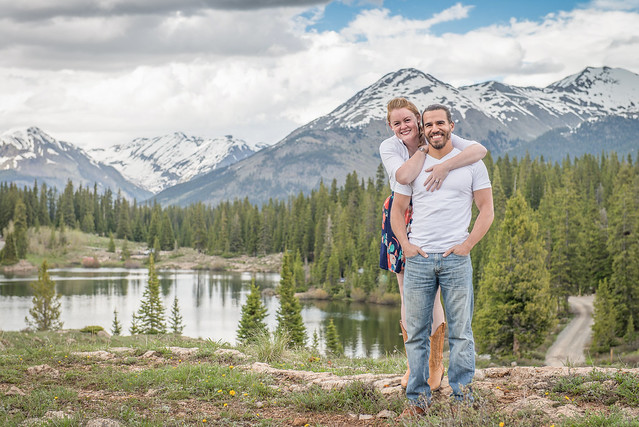
-Tim & Ashley

Instagram: Explore_the_Untamed
www.exploretheuntamed.com

20150614-DSC_0222 by Tim Souza, on Flickr
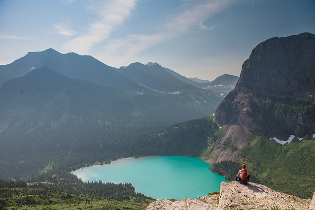
 

Adventurous

Explorer
Connected once again, so I will expound upon the first post with some additional thoughts, as well as the "Why" from my wife, Ashley.


When we first started telling people of our plans to live on the road full-time, the most common responses were “Why?” and “How?”. Some people looked at our plans to quit our jobs and sell our house and belongings as crazy, maybe even foolish. We had a house we just finished fixing up. We had stable jobs. We had friends and family we didn't want to leave behind. Others wanted to know how we could manage to make this lifestyle work. Every once in a while, we got the advice to travel for as long as we could—there's always more money to make, but there's no guarantee of time or health. So here we go, blog post number one on this journey of ours; our attempt to answer the why and how of living full-time on the road.

Ashley's Why

Ever since I can remember I've felt like a restless soul; someone who needs change to stay engaged. As a kid, this manifested in the constant rearrangement of furniture in my room. Creating a newly designed environment. As a teenager, I moved on to frequently evolving fashion choices. As an adult, it has developed into wanderlust; the need to travel, explore, experience new things. There's an ever present pull between the desire to settle down and the desire to move. My future dream is to settle somewhere I love, own a lot of property, build a business, and save every animal possible. But the future dream seems impossible until I've sufficiently satisfied the need to wander.

So there we were, heading into our thirties. We had already done some traveling and moved across the country to a state we had never been to. While for some this seemed like a giant leap of faith, for me it was a stepping stone to a larger adventure. Living in Colorado allowed for the further development of my desires. We were able to hike amazing trails, travel down the random dirt roads we happened upon, and visit small towns with all sorts of different personalities. We were introduced to vast expanses of open space to explore, sometimes going an entire day without running into another person. If Colorado has so much to offer, imagine everything you can find elsewhere if you seek it out.

Tim and I had spoken in the past about doing an extended road trip, but our musings had never come to fruition. The timing never felt right, or we didn't have the funding to feel comfortable in that decision. As I entered my 31st year, the North Winds started blowing (anyone know the reference?). I felt complacent. Things were becoming too routine and I started feeling that need to move again. The difference was, this time the timing was right to do something big. We decided to give ourselves a large enough budget to be on the road for at least a year, but we are hoping to be able to stretch that out even longer. This dream of ours may seem crazy to some, but it's exactly what I need.

DSC_4981 by Tim Souza, on Flickr

“This gypsy heart just needs to wander. Wander to the undiscovered mountains and caves that guard the mysteries of this world. I will unturn every stone, I will walk every unpaved path, I will dive through the darkest seas just to discover the secrets that were only meant for me.” - Chrissie Pinney


The How

When we decided to make this adventure happen, we had a number of things in our favor. We were a dual income family without kids who had been doing a decent job at saving. We also bought a house in the Denver area a few years before the housing boom, which meant if we sold we were bound to make a fair bit of money. This is what created the means for us, so the next step was the planning. What do we live in? Where do we go? How much does it cost? How do we move from a three bedroom house to a truck camper?

What do we live in?
It took us a few tries to arrive at the right decision on this one. I will give you the short version, but you can read the extended version of this story under the “Truck and Camper” section of our website, if you're interested. When making the decision to do a road trip, we owned a 2015 Toyota Tacoma that had a ridiculous amount of off-roading add-ons. The name was Battleship Jones, and he was Tim's baby. That truck took us on all sorts of adventures: camping, off-roading, getting engaged. Although Battleship Jones ate speed bumps for breakfast, his towing capacity wasn't the greatest. Our first attempt at creating a tiny towable living space was a used 1994, 20 foot travel trailer. It was outdated and had significant water damage that required months of blood, sweat, and tears to refurbish. But once it was done, it was beautiful inside. We named him Harvey the RV. Shortly after (mostly) finishing, my parents came to Colorado for a week and we took them around the state for the trailer's inaugural trip. While the trailer worked fine, towing it through the mountains with Battleship Jones turned out to be a bit of a nightmare. Suffice to say, after returning home, Harvey the RV almost immediately went up for sale.

f2076f_47f286bb0e9e4d6b9f2d82dd89bc122f~mv2_d_6016_4016_s_4_2.jpg


On to Plan B. Our next attempt was to order a custom light weight cargo trailer with an off-road package to build out into the perfect tiny home. We went with a black and blue 12 foot trailer on 32” mud tires with an RV door and named him Bruiser. We gave Bruiser a skylight above the bed, a tongue box, outdoor lighting, and an awning. But as Tim started running the electrical for inside the trailer, the deadline for our trip was creeping up quickly. In a last minute decision, we did something I'm still surprised about...We sold the beloved Battleship Jones and bought a 2017 RAM 3500 and a 1995 Lance Truck Camper instead. (Bruiser is a bit of a niche item and is still waiting for the right home—if you might be interested, let us know!).

f2076f_a766e63be8524f7aabda3715571fab2b~mv2_d_4032_3024_s_4_2.jpg


The new set up was (supposedly) move in ready and we named them Lady Godiva and Wobble Baby. With our house under contract and the closing date approaching, we started to move everything into our new house on wheels. Unfortunately, this is where the problems arose. The camper we thought was ready to go had a significant amount of unforeseen issues, including a cracked water tank. On top of that, a week before we closed on the house, we got hit with a hail storm that broke all of the vents and covers on the roof of the camper. Therefore, at the end of June we found ourselves without a house or a working camper. Luckily, we had amazing friends come to the rescue. Our neighbors gave us a place to land for a couple days while we sorted things out and helped us fix everything on the roof before we moved on to friends in Mesa, Colorado where we stayed for 2.5 weeks while the boys fixed the rest of the issues with the camper.

f2076f_7b8e0b6ec38c4f4e94f11ca6b8a1a50c~mv2_d_5299_3537_s_4_2.jpg


Where are we going?
I started the trip planning process months and months in advance of our launch date. I made a trip binder with state road maps and researched each state one by one. As it turns out, it's a bit of a daunting task. Even starting so far in advance, I was only able to research the states we plan to visit in 2018. For every state, I have researched National and State Parks, top attractions, places to hike, must have food, and places to camp, as well as locations of dog parks and vets because I'm a #dogmom. I found the process very helpful because it allowed me to learn the attractions and geography of the different states and gave me a much better idea of the path we would want to follow. Between our launch in July and the end of the year we will move from Colorado through Wyoming, Montana, Alberta, Yukon, Alaska, and British Columbia before taking a winding path across the top of the US and Canada on the way back to Massachusetts for the holidays. In the new year, we plan to swing south and then up the west coast. If anyone has any recommendations of must-see places or has a flat driveway and wants us to swing by, let me know and we'll see if we can make it happen!
 

Adventurous

Explorer
How much does it cost?
This one certainly depends on your priorities. Obviously there is a base monthly cost, which includes things like car and phone payments, storage units, etc. We were lucky enough to be able to pay off Tim's student loans just before hitting the road. While you lose a mortgage, living on the road still costs a fair bit. We like to boondock (find free camping) as much as possible to keeps costs down, but in some places this isn't possible. For instance, when you're visiting large National Parks, it tends to make more sense to stay within the park campgrounds. There's also the cost of gas and food. When you're living in a home on wheels, your gas budget tends to skyrocket. Luckily, since we bought the diesel RAM, our MPGs are much better than they would have been in the Tacoma. We've managed to figure out ways to keep our food budget lower than it used to be by eating less meat (and ice cream *sad face*) and making sure to plan ahead. Since our priorities tend toward activities and staying on the road, we don't plan to take in too much of the restaurant scenes as we travel.

Random costs we also needed to consider are activity costs, health insurance, and dog boarding. Since most National Parks in the U.S don't allow the dogs on trails, we will end up sending them to dog sitters on multiple occasions while we travel. Health insurance was a tricky one for us. We didn't qualify for any good state programs and couldn't afford the cost of Cobra without any income. It took a lot of research, and endless spammy phone calls, but we finally decided on a private plan with nationwide coverage that costs us about $300 a month. All in all, it takes some planning and consideration when deciding on a budget and you can expect to spend at least a couple grand per month while on the road.

Downsizing
This part of the planning process was definitely the most difficult on my end. While Tim did more of the truck/camper planning, I did more of the house selling, packing, and trip planning. As I'm sure many of you can relate to, when owning a house you tend to collect more things than you need. I took a couple months to go through our house room by room and make “keep”, “sell”, and “donate” piles. If we hadn't used something in a while or didn't love it, we didn't keep it. Even still, we were left with enough stuff to jam pack a 7x15 foot storage unit. Selling things was the majority of my frustration—if you don't need the money, I'd skip that part.

Even harder was deciding what to bring on the road with us. Since we have three dogs along for the ride, we had to make room for their food and accessories, including food (this literally takes up about 1/5 of our floor space), leashes, medications, and jackets. Given that we will be in a camp-like setting the majority of the time, picking out the clothes to bring was less of an issues. We brought mostly the same clothes we would for any other camping weekend, and threw in a few jeans and sweaters. The hardest part was choosing the shoes and jackets. We both had a lot of jackets, so we dedicated an entire bin to them. Still, we could only fit about a third of our closet. Eliminating shoes seemed easy for Tim. Casual, hiking sneakers, hiking boots, and sandals. For me, not so much. I ended up with three pairs of sneakers/hikers, my LL Bean boots, and sandals. So far, I think I chose correctly. I think overall, less is more. Truck campers aren't large and the less clutter the better! Especially when you're constantly maneuvering around a 70 pound dog who insists on laying directly in the only floor space available. I'm looking at you, Marley.


Final Thoughts

The process to get here took a lot of work and frustration, and through all of the snafus we tended to wonder how our luck was so bad. But in reality, it also took a lot of luck to get us where we are today. Thanks in great part to the Denver housing market, we are in a position not to work for a while. We are lucky to be healthy enough to go on this adventure. And we're also lucky to have found a partner in each other who wants to upheave their entire life and go make the most of it. Let the adventures begin!
 

Adventurous

Explorer
After 2.5 weeks of technical difficulties, our trip was officially up and running on July 18, 2018! We waved goodbye and hit the road; destination: Tetons. We decided to weave our way up through Colorado to hit a state bucket list item on our way out, Rifle State Falls. I'd had my eye on this place for a while (thanks, Pinterest) and was pretty excited to see if it lived up to the idea in my head.

We leashed up the puppers and hiked a short trail that lead to the top of the falls, which is a triple, 70 foot waterfall. The trail allows you to cross over the top of the falls and down the other side, where you'll find multiple sections of small caves to check out. A few are large enough to duck or climb into, and the general feel of the area was reminiscent of the jungle in Costa Rica.

f2076f_a22c3a125544410c97d1c55804250fc1~mv2_d_3024_4032_s_4_2.jpg


Once you reach the base of the falls, there are side trails that will also lead you up behind the falls for a mistier approach. The park allows camping and was a great stopover on our way out of town.

f2076f_57b4082dec57471187ad9712771797ae~mv2_d_4032_3024_s_4_2.jpg


The next day we made our way out of Colorado, through Utah, and up into Wyoming. Ah, Wyoming. Wind, plains, and broken glass. The broken glass is so abundant we've concluded that it must be the state plant of Wyoming. That said, I'll take free camping where I can get it.

f2076f_cca06e56187b4cb6a392526cd1944663~mv2_d_4032_3024_s_4_2.jpg


For those of you who don't know, in early fall 2017 Tim and I took a dog-free vacation and went up to the Tetons and Yellowstone. We did Yellowstone first and spent a few days searching for all the wildlife we could find in the quiet morning hours and shoving our way through hoards of tourists to see all the other attractions during the day. We enjoyed ourselves, in spite of the growing presence of wildfire smoke from the fires burning in Montana. Sadly, by the time we made it down to the Tetons, the smoke was so thick that the mountains were completely obscured. We ended up heading home early, rather disappointed.

Therefore, even though this was our second time in the park, it was our first time actually seeing the peaks. Consensus: They. Are. Awesome. So craggy and majestic.

Since we arrived on a Friday evening, all the campgrounds were full. Good thing we had an insider tip for a bit of boondocking in the Tetons! (Thanks, Shannon). We headed east from the Moulton Barn and discovered we certainly weren't the only ones in on the secret. Luckily, there was enough room to cozy on into a spot and settle in for the night, mountain view and all.

f2076f_f571818172ab48dd8eb50f0e152cb8b3~mv2_d_6016_2480_s_4_2.jpg


The next morning we nabbed a spot at Colter Bay Campground and spent the morning puttering around in the rain, crossing our fingers that the weather and haze would move out for our big hike the next day. In the afternoon we headed into Jackson Hole to check out the town and drop the dogs off for their overnight stay.

f2076f_64723824ecf2487fb95ca2adc440a188~mv2_d_3024_4032_s_4_2.jpg


f2076f_0c9c95c6b17d448e876f61e2fc3151f5~mv2_d_3024_4032_s_4_2.jpg


The next day we got lucky—most of the haze from this summer's fires moved out overnight and we took the first ferry out of Jenny lake around 7am to hike to Lake Solitude. Pro tip—they give a morning discount for paying in cash!

f2076f_65270ca20f43494a84d22015d42e3b71~mv2_d_3088_2320_s_2.jpg


The trail up through Cascade Canyon to Lake Solitude is about 15 miles and just over 2,600 feet of elevation gain. It was our longest hike to date, and by far the best. It was worth every step, including the ones I felt for days to follow. I cannot stress enough how amazing this hike is. As you hike along the river on the way up you keep thinking “This is a really nice hike.” Then, you reach a certain point, turn around and realize... “This is most amazing vista I've ever seen.”

f2076f_c064f6af3ae64b46871c899e7ca0c439~mv2_d_3024_4032_s_4_2.jpg


f2076f_118f5eb66ae142acb20217cbc7cd80bb~mv2_d_3024_3780_s_4_2.jpg


f2076f_f131cee403554caa9bf20b651f389580~mv2_d_5576_3722_s_4_2.jpg


f2076f_76da2ea5faf44ca183634b8fead0fcc7~mv2_d_4032_3024_s_4_2.jpg


It's like every time we turned a corner the views were more spectacular.

f2076f_74a1ca9f25f3473e9201284871f46bd0~mv2_d_5513_3680_s_4_2.jpg


The trail leads up through fields of wildflowers and cascades and ends with a glacial lake and stunning views. And marmots. All the marmots.

f2076f_ad4f84136be94221b4aa00524edfcc8b~mv2_d_4621_3085_s_4_2.jpg


And impromptu snowball fights. :)

f2076f_c69c17e3e99d4b1d9b677ec121e5b9e1~mv2_d_5350_3571_s_4_2.jpg


The view at the top was just spectacular. The lake is entirely fed by the snow melt, as evidenced by the melting snow fields dotting the valley. It was the perfect place to lay back, close your eyes, and listen to the sounds of nature.

f2076f_16b0d73bf9e04a8abf921befae6a738f~mv2_d_8368_3448_s_4_2.jpg


f2076f_a595be055e7d4a21aa917908010f2ec3~mv2.jpg


Tim though, is apparently into cryotherapy, and decided to take a wee plunge into the lake. Twice, since the first time I didn't focus the shot correctly :)

f2076f_14efa0a5047749ca80b41161456b1eee~mv2_d_5560_3704_s_4_2.jpg


Best part of the hike back down, a new set of views. We exchanged what was in front of us for what was behind us and it was no less breathtaking, perhaps more so.

f2076f_e509936860f248eb8b46aaa2a50cae2a~mv2_d_5637_3763_s_4_2.jpg


f2076f_f15c1e497bdc4bb9b8ee2c37fab39f5a~mv2_d_6016_4016_s_4_2.jpg
 

Adventurous

Explorer
On our way down we decided that our hike would only be made better if we were able to see a bear. We've been lucky enough to see a lot of the other big game animals, but the bear was still eluding us. About two thirds of our way down the mountain we came around a bend and BAM!

f2076f_45d7b6850dd14238bb1a9f839457f2d7~mv2_d_4834_3227_s_4_2.jpg


A giant bull moose casually walking up the trail towards us. This was both awesome and terrifying. Statistically, you are more likely to be killed by a moose than a bear. As I am “calmly” making my way back up the trail away from the moose, Tim is trying to get himself killed by taking photos and falling in ditches. Luckily for us, the moose decided to make his way off the trail and disappear. Private moose showing, check.
As we got closer to the end of the trail, whisperings of a bear started to make their way to our ears. With hope in our eyes, we took off running. If there was a bear, we were going to find it. And we did. He was just on the other side of the river peacefully munching on grass and letting us take all the photographs we wanted, before gliding into the water and swimming away. Lake Solitude Trail: Officially the best ever.

f2076f_92237923323f4ae69268f9c269a65097~mv2.jpg


Later that evening, we made our way over to Moulton Barn hoping to capture a version of the iconic shot. Unfortunately, there was too much haze (again with the wildfires) for a spectacular sunset. I'm sure Tim is disappointed, as he seems to be whenever there is a cloudless sunset, but he was still able to manage this shot:

f2076f_21a168c416814b5ab8e60fa7f91b2369~mv2_d_4096_2144_s_2.jpg


Looks like we will have to come back in the cold months, when wildfire smoke is a near impossibility. Maybe with some fresh snow on the ground :) Although our time in the Tetons was rather short this trip, there was no shortage of smiles and amazement. The bar was certainly set high for the rest of our trip.

f2076f_946877eb4f434f438054ea588f92d8fd~mv2_d_4493_2999_s_4_2.jpg


Next stop, Montana.
 

the deputy

Member
Inspiring. I'm going to somehow force my wife to read this. I've "finally" talked her into a camping trip next month, baby steps they say. Really, enjoying your journey.

Brian.
 

Adventurous

Explorer
Inspiring. I'm going to somehow force my wife to read this. I've "finally" talked her into a camping trip next month, baby steps they say. Really, enjoying your journey.

Brian.

Way to go Brian!

When I first met my wife 10 years ago, she was a definite city girl. Over the years, I was somehow able to talk her into camping and she’s slowly become an outdoor kinda girl. I think once she saw how beautiful the world around her could be she was hooked.

Good luck with your wife! And I appreciate the good words.
 

Adventurous

Explorer
Montana and Our Favorite Bits of Glacier National Park

f2076f_069db20922be49f0b25f1ad7cc42fa2c~mv2_d_2804_2100_s_2.jpg


After leaving the Tetons and heading up into Montana, we traveled the route through Big Sky and Bozeman. We stayed for a few days to hike, attend the Big Sky Farmer's Market for some Flathead Cherries, and catch up on errands.

f2076f_1db12dc690b4490e8a7406bf1b3972ba~mv2.jpg


f2076f_541adad5b99649adaecf83247f640034~mv2.jpg


f2076f_7f7869ba6e904cb6902e4417ffc00be6~mv2.jpg


f2076f_2d0a2f5e8d2b484898b5cc68969743d0~mv2.jpg


After passing through Missoula, we landed in Columbia Falls and made a home for the night at the Super 1 Foods, just outside of Glacier National Park. Shout out to Super 1 Foods; this place is awesome, guys. Besides allowing free overnight parking just outside the park, they also have 25 cent soft serve...who has ever heard of such a thing?? We definitely got our money's worth.

In order to enjoy the park, we once again had to board the dogs. We took them over to Three Dog Ranch (http://www.threedogranchmontana.com) in Whitefish and were able to board them for four nights for a super reasonable fee and felt totally comfortable leaving them there, which is a nice change from how I normally feel leaving my babies. How could I not worry about these faces?!

f2076f_d24555aa767344c9bb81f723f4312205~mv2_d_3024_4032_s_4_2.jpg


Navigating Going to the Sun Road
Glacier National Park has one main road that crosses the park west to east called Going to the Sun Road. The road is about 50 miles long and was first opened in 1933 after over three decades of planning and construction. Due to the nature of where and when it was built, the road is narrow and winding with a number to rock walls that overhang the road. Therefore, vehicles longer than 21 feet and taller than 10 feet are not allowed to drive the majority of the road. Our rig is 23 feet long and 12 feet tall. Ruh roh! Good thing there is a free shuttle that will drive the road for you! Bad news is: we didn't know about this shuttle service until after we rented a car for the day. (The shuttle stops at all major areas, just don't miss the last shuttle of the day that leaves Logan Pass by 7pm!)

Hidden Lake Hike
The first hike we did was to the Hidden Lake Overlook out of Logan Pass. Although it's slightly less than 1.5 miles to the overlook, expect a fair bit of climbing. A good chunk of the trail was somewhat consistent with the stair stepper at the gym, just with much better views. The biggest difference, though, is the amount of furry friends you can make along the way. There is an abundant amount of ground squirrels (larger brown version of the typical grey tree squirrel) that are quite used to humans and will come right up to you, as well as mountain goats. The goats varied from big boys to mamas and babies, but all seemed completely indifferent to human presence; going so far as to walk along the trail with us. (Always remember to give wildlife a safe space because it's WILD! You never know how animals will react).

f2076f_0597c76e94da4d8d85f7266d8bb51383~mv2_d_6016_4016_s_4_2.jpg


f2076f_f2a43b7b10de4151ba850b295e96c8fe~mv2_d_1386_1940_s_2.jpg


f2076f_28ec54b7236b4c6998abafcaa7cb3b19~mv2_d_4515_3014_s_4_2.jpg


f2076f_d4ad8f93c8af420ca1caea46416f81fc~mv2_d_4032_3024_s_4_2.jpg


Once you reach the overlook, you get a nice view of Hidden Lake below. At this point, you can choose to hike another mile and a half down to the lake, which I hear has nice clear water and the opportunity to spot a bear or two. We skipped this part due to time constrictions, but we did wander down the path a quarter mile of so for a different perspective of the lake and more mountain goats.

f2076f_1e38cc580a614c48845d8f222ebc9b0a~mv2_d_4032_3024_s_4_2.jpg


f2076f_dd066482ef4142939a8c76a2c19da55d~mv2_d_4032_3024_s_4_2.jpg


At the end of the hike, we decided to pop across the street to hike a tiny sample of the Highline Trail. This is a 28 mile loop that starts with a narrow shelf trail out of Logan Pass. I've heard great things about it, even if you only do the first 7.5 miles out and back.

f2076f_30506c245b714eb6a71c663826b99737~mv2_d_5439_3159_s_4_2.jpg


f2076f_4a23fa69f1d34999acf985ffc5d1bd56~mv2_d_4032_3024_s_4_2.jpg


f2076f_10d54b8683474d89b70a2de7e23344c8~mv2_d_6016_4016_s_4_2.jpg


f2076f_08017c3cf5834a0a96b705ab5e88a3c4~mv2_d_5288_3530_s_4_2.jpg


St. Mary and Virginia Falls Hike
For Tuesday's outdoor adventure, we decided to take the shuttle up to St. Mary & Virginia Falls. The Hike to Virginia Falls is about 3.5 miles roundtrip, with St. Mary Falls and other cascades as stops along the way. The first quarter mile of the hike took us through some old wildfire burn and then continued into more dense forest filled with thimbleberry bushes (yes, these are edible!).

f2076f_b27001b34e024e0788ffc38f5012f520~mv2_d_3024_4032_s_4_2.jpg


It's an easy hike down to St Mary Falls, which is a three-tier waterfall that drops down 35 feet into an beautiful aqua colored pool below. Theres a footbridge that spans the third tier of the falls, where many hikers choose to take a plunge into the icy water to cool off.

f2076f_6ae7136cf9fe4795826c5e0ab51fc26b~mv2_d_1909_2545_s_2.jpg


As you continue down the path, the crowds lean out and you come across a number of other cascades on your way to Virginia Falls. Make sure to stop and explore those, as well, because they're all noteworthy.

f2076f_505596d728984b85a3e88c271a8fe1a1~mv2_d_3088_2320_s_2.jpg


f2076f_4cc39218b47449ca8232c2d1e3ba33b7~mv2_d_7293_3428_s_4_2.jpg


At the top of the path, you reach Virginia Falls, which is a more accessible 50 foot waterfall. You can get quite close and feel the cool mist spray—feels great after hiking up there in the summer!
 

Adventurous

Explorer
f2076f_28aa7e799246444caa934549941e3a3f~mv2_d_3019_4029_s_4_2.jpg


f2076f_3c21b3d333cc4a58b282707055ae0b3c~mv2_d_3021_4027_s_4_2.jpg


As we made our way back down to St. Mary Falls, a number of people had started jumping into the pool. After watching other people make the leap, we were convinced there weren't any hidden rocks, and decided to jump ourselves. I call this the Penguin Method, since penguins will push a “test” penguin into the water to ensure there aren't any predators lurking before the rest of them jump in :). It was a fun and icy way to end the visit before hiking back out. Although, we did have to stand the entire shuttle ride back to avoid soaking their seats.

f2076f_d86b2ba9f8e54d88a0ca80e6034663ed~mv2_d_3024_4032_s_4_2.jpg


f2076f_b2919c992aa546bc8d39ca07b2b672d1~mv2_d_3024_4032_s_4_2.jpg

Hiking Grinnell Glacier
On our third day in the park, we got up early to drive the almost 2 hours up to the Many Glacier part of the park and hike Grinnell Glacier. BE WARNED, my people, the road from Two Medicine to St. Mary's is WHACK (are you all able to guess my age now?). This is a narrow, old, shelf road without a barrier that I hope has seen better days. There is a ton of heaving and it's a bit like being on a road rollercoaster. For those of us truck campers who are top heavy, this is less than ideal. Travel slowly.

We arrived at Grinnell Glacier Trailhead a bit before 8am and were already amongst a fair number of other hikers. When it comes to hiking in Glacier, if you want to avoid the crowds, get up with the sun. If you don't get there early, you and your 300 other friends will be hiking together. Also, Pro Tip: Always carry bear spray. You are in bear country. If you come face to face with a grizzly, statistics show bear spray is infinitely more effective at deterring an attack than anything else, including a firearm. Even with bear spray in tow, common sense and avoidance is always your best bet for animal encounters.

Funny Side Story: When we were in the grocery store in Columbia Falls we overheard a woman telling her friend how she had been asked by a tourist if you were supposed to spray the bear spray at the bear, or if you sprayed it on yourself like a bug spray. Please, don't mace yourselves, guys.

Grinnell Glacier is definitely our most recommended hike from our park experience. It's 11.4 miles roundtrip with 2,450 feet of elevation gain, but it's well worth it. You have beautiful views the entire way, including the chance for wildlife. There is also a way to cut down the length of the hike by taking the boat across the lakes, although I'm not sure how much mileage it eliminates. The path up is a steady grind and passes through dense forest, thick bushes, and rock ledges. Once you crest the treeline, you'll be hiking through more of a rocky area (although the trail itself isn't too rocky) to the glacier. Be forewarned, a waterfall drops onto a piece of bench cut trail at one point, so be prepared to get a little wet.

f2076f_af7759bedbdb4cb8b76123dfc5b23913~mv2_d_6016_4016_s_4_2.jpg


f2076f_5450344ddc3d42c8814364a278cc5736~mv2_d_4032_3024_s_4_2.jpg


f2076f_8c0c3972433e436abc97962fa66aca1f~mv2_d_3024_4032_s_4_2.jpg


f2076f_f3730fae43fc4cfe89bd1a855954f952~mv2_d_7252_3447_s_4_2.jpg


f2076f_b43ad348baf8452f8632c96e9834ca31~mv2_d_3024_4032_s_4_2.jpg


f2076f_ed269e3a27d14d3fbfda0e7eeb2af459~mv2_d_5576_3313_s_4_2.jpg


f2076f_1ea3f9787d774e7d857a4813b3e3b177~mv2_d_6016_4016_s_4_2.jpg


Grinnell Glacier sits above the top of the trail and the run off creates the glacial lake in front of you. Small icebergs float in the waters and give off nice cool breeze, so make sure you bring extra layers. A few brave souls took a polar bear plunge of sorts while we were there. We took our time at the top, eating lunch and laying in the sun on the rocks.

f2076f_80d9353530cc450185efe7c6dda856d1~mv2_d_4032_3024_s_4_2.jpg


f2076f_d90f299a8fba4d10a456da53c3cdb570~mv2_d_7386_3385_s_4_2.jpg


Overall, the hike took us about 5.5 hours, including about an hour at the top. On the way down, we were inundated with people hiking up, but we also had a fun run in with some big horned sheep who put on a show for us, too.

f2076f_28d812e2c44a4663aa33cf9468e5fa18~mv2_d_3799_2536_s_4_2.jpg


f2076f_da61bc4afce94115acb8e82e2042f3ff~mv2_d_3794_2533_s_4_2.jpg


A bike forum friend of Tim's happened to be camping in Many Glacier at the same time we were there, and was generous enough to lend us his water toys. So after we were done hiking, we went over to Swift Current Lake and took out the kayak and stand up paddle board for a trip around the lake. It was nice to add a little water portion to our trip. We also blew up the donut tube Katy gave us for our trip and had a little float after :) A relaxing way to end our trip!

f2076f_3e8295e3a1ce4f0f8dcab386666dd386~mv2_d_4000_3000_s_4_2.jpg


f2076f_41b17501cde74ea7a893d1ffdc6cf5c8~mv2_d_4032_3024_s_4_2.jpg


f2076f_5df6e31906804b0a9fb09bc9614c6a59~mv2_d_6016_3711_s_4_2.jpg
 

Adventurous

Explorer
Whittier, Alaska
Our first week in Alaska was all rain. The locals tell us it's the rainiest summer they've seen in a long time. Mother nature chose not to show us Denali, so we moved south in search of better weather. Once we hit Anchorage, we saw a break in the weather forecast and decided to keep pushing south to hike Portage Pass. I was in search of that iconic looking Alaskan view I had yet to witness. Once we started driving south from Anchorage, it was as if the entire landscape transformed. The ocean came into view with giant mountains rising straight out of the water and glaciers appeared to be all around us. The views are incredible, which is also why it's such a dangerous stretch of road. Watch out for drivers with wandering eyes!

f2076f_e4e280b14a124409bc1a9762b959b1dd~mv2_d_4032_3024_s_4_2.jpg


The Portage Pass hike leaves out of Whittier, Alaska. This is a tiny coastal town that we knew nothing about before going. As it turns out, the entrance to Whittier is a bit different than most towns. Google Maps didn't give us a warning on this one. “Hmm, the road looks like it goes straight into the mountain. There must be a tunnel.” Was there ever. When you pull up to the toll booth ($13 for passenger vehicles, and yes, they do accept credit cards) they give you a lane number and you pull into one of the six lanes based on the type of vehicle you're driving. Then a monitor will tell you when it's ok for your lane to go. Why so intricate? Turns out the only way in and out of Whittier by car is through a single lane train tunnel. Once the train and the cars on the other side of the tunnel have gone through, then it's your turn. The tunnel is about 2.5 miles long straight through mountain rock. You drive with your tires on either side of the tracks and there are emergency shelters every 1,600 feet or so, just in case. It's a trippy and unusual experience.

f2076f_3a942c0f7ff747279dd6d2b9e7eca3f5~mv2_d_3024_4032_s_4_2.jpg


Portage Pass is a relatively steep hike up to the top of the pass, and once there you can choose to keep going down to the glacial lake. The hike up to the pass runs along hoards of wild raspberry bushes, so if you hit it at the right time of summer you get a free snack along the way. We were relatively late, but Tim climbed through the thorns to snag me one of the last nice red ones.

f2076f_697f4ffbb69742fe9ec8c48f04defb48~mv2_d_6016_4016_s_4_2.jpg

f2076f_8c7d41d4b8ab4003b84fcb453e8f3f0b~mv2_d_6016_4016_s_4_2.jpg

f2076f_703b3294f0bb4401bffa9ff8d8b28cf7~mv2_d_6016_4016_s_4_2.jpg

Turns out it was a bit bitter :)

As we crested the pass we were delighted with the most spectacular views—the Alaska I always imagined. A small pond on the pass, and sweeping mountain views centered on a glacier.

f2076f_a7153baa759d49edb01c1df7eb1f956b~mv2_d_6016_3416_s_4_2.jpg

f2076f_21d232989de3485bbe0ed066a87fc23e~mv2_d_6016_2832_s_4_2.jpg

f2076f_c8b887b0c7034066b8971db99f13b52d~mv2_d_6016_2900_s_4_2.jpg


The dogs were loving life as we let them off leash to swim and quickly found out that the pond was a bit deeper than they anticipated.

f2076f_0f7e683437004979a5d467de0502ef4b~mv2_d_5442_3633_s_4_2.jpg


Continue down to the bottom of the trail and you'll find a black sand beach leading into a large glacial lake. Some people on their way up reported seeing the glacier calve (break off) into the lake multiple times. We spent a lot of time down there playing with the pups and enjoying the stunning surroundings before making our way back up.

f2076f_14891e9d879349d686cb80ae1a78fd18~mv2_d_6016_3740_s_4_2.jpg

f2076f_cdd6458fa02c44c1a07a027c30140080~mv2_d_4847_3236_s_4_2.jpg

f2076f_c4b2990ff2dc4de4a62709487d295038~mv2_d_5352_3241_s_4_2.jpg

f2076f_f77e80fc0ff343a2b01b03b00e3550f9~mv2_d_4761_3339_s_4_2.jpg

f2076f_d36d5ba6344641219a5d937775db074e~mv2_d_6016_4016_s_4_2.jpg

f2076f_f8db13f42dd443e0b87892e5676f65a5~mv2.jpg

f2076f_43d619d02846476cb8d6ce4970fa8b86~mv2_d_4293_2866_s_4_2.jpg

f2076f_cf258a6f71eb4c6fa1ccaf18a87c29ad~mv2_d_4881_3259_s_4_2.jpg

f2076f_38a23061376c4ea4830c80022f215c5e~mv2.jpg

f2076f_851711bc87774c6fad77abb2ed71ae03~mv2_d_6016_4016_s_4_2.jpg


If you head to Alaska, put this hike on your list. After all the rain we had in the beginning, I feel like this hike gave me life. It was exactly what I needed at that time and really got me excited for what was to come on the rest of the peninsula.

Soldotna, Alaska
Soldotna is a landlocked town on the way from Anchorage to Homer. It's a great stop for campers and RV-ers because it's the biggest town in the area and has everything you might need to refuel. There's a Fred Meyer, or Freddy's, in town that the locals tell us is the largest in the country. I'd be inclined to believe them. It's definitely one stop shopping, and as a bonus they allow overnight camping and a dump & fill. For those with diesel rigs, their gas station also has the best price we've seen on DEF. You'll also find a laundromat in town that also offers nice, long showers. Head up the road to Kenai for a yummy pizza at B&H Pizza.

While you're in town, be sure to go check out the wood shop 3 Guys No Wood. We loved our visit here. They will show you the wood shop and how they turn bowls and have all sorts of amazing pieces. They even offer reasonably priced classes if you feel inclined.

f2076f_ce210ff8fdf0417ebf66e071aaf523d8~mv2_d_4032_3024_s_4_2.jpg
 

Adventurous

Explorer
Homer, Alaska
On a clear day, the road from Soldotna to Homer will give you great views of the huge volcano across the bay.

f2076f_1574db3f857b4bb099091f8d173132f2~mv2_d_4032_3024_s_4_2.jpg


We arrived in Homer on another rare sunny day, but it turned out to be our coldest day yet. Who would've known that little spits of land that stick out into the sea in Alaska could be windy? We grabbed a campsite in Mariner Park, which is at the beginning of the spit. It was right on the water, but a bit cheaper than going to the end of the spit. Note, a lot of the town owned parks that allow camping operate on a first come-first serve basis, so get there early. It was here that we met our new friends, Wendy and Tom from Florida.

f2076f_dbe09545abb44f30bba265087f935895~mv2_d_3088_2320_s_2.jpg


They've spent many a summer up in Alaska and had loads of advice on where to go and what to see. They even gave us a fresh smoked salmon filet that Tom had caught on the river. Wendy has an unbelievable memory and should probably write a travel book. I have trouble remembering what I ate for breakfast, but Wendy can tell you the campground in Maine she went to a few years ago that will bring a setup to your campsite for cooking lobster over the fire. One of the great aspects of this RV lifestyle is meeting all sorts of people from around the world who have this one thing in common.

After chatting with Tom and Wendy we made our way down the spit for some lunch. The spit is known to be a bit overpriced, but if you're heading that way, you should definitely get some fried halibut. We went to this tiny stand called AK Fish Fry because they had great reviews. Turns out they do, in fact, know how to fry a fish to perfection.

f2076f_6b241bfb126d4b0fbde471540d8b2ac4~mv2_d_3088_2320_s_2.jpg


The spit has a bunch of cute shops, my favorite being Salty Girls. We were also lucky enough to spot a lone otter right off the dock with the small boats. He kept diving down and bringing crabs up to munch on. It was simultaneously adorable and disturbing as he ripped their legs off the eat them. This is the one I most regret not having the good camera for, so we took mental photos. Wendy told me that when the water is clear you might also be able to spot starfish in this area, but we didn't see any.

f2076f_9ccc8394da7946bca33ec648deb65e83~mv2_d_4032_3024_s_4_2.jpg

f2076f_6b241bc3405c4075b28ea4192aceb45f~mv2_d_4032_3024_s_4_2.jpg

f2076f_b141e67aff9a470ba9d5f28d0a95904c~mv2_d_3024_4032_s_4_2.jpg

f2076f_992cb57a041a43a4badeefb8ff1278e4~mv2_d_4032_3024_s_4_2.jpg


If you have dogs, or even just want a more off the beaten path beach to go to, head down to Bishops Beach down by Old Town. The locals drive their vehicles right onto the beginning of the beach to hang out and the dogs all play off leash. (If you have small dogs this is not recommended because they're snack-sized for the local eagles). The dogs had an absolute blast playing here—Marley's first time at the ocean! If you're lucky you might even spot some seal heads bobbing off shore.

f2076f_9bf8492994d046d7a33d4a9e581b0f55~mv2_d_4032_3024_s_4_2.jpg

f2076f_9b464fc89cc74f4eaa5b2e79b658d0b6~mv2_d_4032_3024_s_4_2.jpg

f2076f_0d6c6a0171fd40298740e0b88cd6aec6~mv2.jpg


Fun side note, as you walk on the beaches in Homer, you'll notice black lumps of varying sizes all over the place that look like coal. Turns out, they are! There's an underwater coal seam on the Kenai Peninsula near Homer that the ocean breaks pieces off of and washes ashore during high tide. The locals can often be found collecting these hunks of coal; they will later be used to heat houses throughout the winter.
If you're staying at Mariner Park, it's a short walk down the street to Three J's Pizza—we got good pizza and a nice view for dinner. They're located right on the shallows during low tide and tons of birds hang out just outside to have their own dinner.

f2076f_cd4d1c1ebab44ea58a36d7301ed3a8ac~mv2_d_4032_3024_s_4_2.jpg

f2076f_cbc4e0e8a80e44d8bc0f3fff7d9fb118~mv2_d_4032_3024_s_4_2.jpg


Our second day in Homer was intermittently rainy, so we decided to head onto the spit to visit a few shops we missed and get a drink at the Salty Dawg Saloon. The Salty Dawg seems like a mix of tourist and local, and includes a patio and pool table in the back. The interesting thing is that the entire bar is filled with signed dollar bills. It appears to be a tradition dating back decades, and if you pass through feel free to pin up your own signed bill. Don't expect a large variety of beers though. It's slim pickings, and although most of it is local, everything is either bottled or canned.

f2076f_3d3f893c591d45ee8e7f72c7f8b6408b~mv2_d_3088_2320_s_2.jpg

f2076f_2c31a74733ef4b88885367f619d189f5~mv2_d_3024_4032_s_4_2.jpg

f2076f_06148703dd6e4ada9d946e63645f0b37~mv2_d_3024_4032_s_4_2.jpg

f2076f_fee0a25da01443c89b6b6a6a1265e5fb~mv2_d_4032_3024_s_4_2.jpg

f2076f_31edf899fcf34199b3a4695cf1d1f706~mv2_d_4032_3024_s_4_2.jpg


If you're into jewelry, the local tradition is using mammoth tusk and walrus tusk ivory in their pieces. The ivory is harvested from the permafrost in Alaska and has been used in jewelry for centuries. We stopped into High Tide Arts on the spit and the owner, Leslie Klaar, makes all sorts of nice jewelry. Her husband is a hunting guide who collects big game sheds (antlers) and makes knives with antler handles. They were both great at creating traditional pieces with modern flair.
 

Adventurous

Explorer
The Russian River
After a couple days in Homer, we were ready to hop to the next place, and headed to the Russian River. We heard whispers of bears here, so we couldn't pass it up. We got a campsite for the night right along the river and hiked a couple miles in to the Russian River Falls. The river is home to one of the hardest races we've ever seen: The Salmon Run. This is one of the most fascinating and gruesome things we've witnessed. Every year, the salmon swim upstream to spawn. They use the protected areas under the river banks to lay and fertilize their eggs, and then they die. Their remains help nourish the entire environment of that area. Lots of the fish don't make it all the way upstream, however. They get badly beaten on the rocks as they launch themselves upstream, they die of exhaustion, or they get scooped up by bear or fishermen. All along the stream and at the falls you can pinpoint the favorite bear hangouts based on the amount of fish remains in that area. That's also where the magpies and seagulls will be.

When we made it to the falls, we were amazed at the sheer number of fish. Thousands of salmon were making their best attempts to jump up the several levels of falls. Some were exhausted and hanging out in little pools to rest. Some had already succumbed to their journey. The falls were relentless and damaging. Their resolve to make it to the top was admirable, to say the least. We stayed there for at least an hour trying to catch a fish on camera at the perfect moment as it leapt from the water. We cheered when they made it. We felt for them when they got washed down a level. Even though we didn't spot any bears, it was quite the experience.

f2076f_2972eb8ceab34de4815cb61f6b721fde~mv2_d_5212_3479_s_4_2.jpg

f2076f_917460f64d2d443ca88483011ea49192~mv2_d_6016_4016_s_4_2.jpg

f2076f_3e02793c045a47d4afea806b3808e024~mv2_d_5080_3391_s_4_2.jpg

f2076f_13883b99bb8d4a47b06161487baa4fc3~mv2_d_4217_2815_s_4_2.jpg

f2076f_0dccf5e23c554e3f99be0e7ee85336df~mv2_d_5296_3536_s_4_2.jpg

f2076f_4634ed9aa49041779242599c55d504e0~mv2_d_6016_4016_s_4_2.jpg


The next morning we got up early to walk the river trails in search of the seemingly elusive bear. It was crisp, with fog coming off the water. The fishermen were quietly reeling in fish up and down the river. We failed on the bear front, though. We were told that a fair number of the fishermen have been charged by the mama bears that frequent the area lately, though, so maybe that's a good thing.

f2076f_64286745ae7c4d34bf9549570a69d10a~mv2_d_4032_3024_s_4_2.jpg

f2076f_77df61e2c9e5491689364d825b170ca8~mv2_d_3024_4032_s_4_2.jpg

f2076f_d5484ecf7fcb48569f446ca3974e1385~mv2_d_3088_2320_s_2.jpg


Seward, Alaska
After walking the Russian River that morning, we booked it down to Seward for a noon wildlife boat tour with Major Marine. We were originally going to pay a lot more to go on a small 6 person whale tour because we figured we would get a lot closer to marine life near the shore in the smaller boat. However, after finding out that it was late in the season and most of the whales had already migrated to warmer waters, we decided to go with the cheaper tour. Seward was insanely windy, but luckily once we got out on the water the wind died down significantly. I chose one of the shortest tours offered, but it turns out that 5 hours on a tour boat still feels like an entire day.

We got the first sunny day in Seward in weeks, so we were able to go pretty far out to see Bear Glacier, the longest glacier in the Kenai Fjords National Park measuring 13 miles long and 2 miles wide. We also saw what the captain described as “the last whale in Destruction Bay”. It was a lone humpback who made a couple appearances for us. Other wildlife included otters, sea lions, sea birds, a puffin, harbor seals, and a bald eagle. It was a great cruise for people who have limited mobility, limited time, or prefer to have sights delivered to them. For us, it was a bit lackluster. Next time we will be more likely to choose one of the kayak tours.

f2076f_a65b7b34107b45e69f3548acaa928ffd~mv2_d_4226_2821_s_4_2.jpg

f2076f_d5d91de2013d45baa758ee0cdd35fd25~mv2_d_2050_1369_s_2.jpg

f2076f_83b3b807c4594feb94ce7dfdb0ec458f~mv2_d_4032_3024_s_4_2.jpg

f2076f_16d26c8a588641cb86d6fcd7b6647349~mv2_d_4032_3024_s_4_2.jpg


One of the gems we discovered in Seward was our boondocking site. On the road to Exit Glacier & Kenai Fjords National Park we discovered small, free pulloffs in the trees. We were initially deterred by signs that looked like no camping signs, but they turned out to be area use rules. It allowed us to back off the road just far enough that we felt super secluded and a small path lead down to the river so the dogs could play. It was quiet and made for the perfect sleeping conditions.

f2076f_a18f9d7e99394a1783eb6e90a039166a~mv2_d_3024_4032_s_4_2.jpg

f2076f_b07ae9058ed34bf896bd27e9db49484e~mv2_d_4032_3024_s_4_2.jpg

f2076f_4998ccca3d2949cbb9eb1df37bed8ef1~mv2_d_4032_3024_s_4_2.jpg
 

Adventurous

Explorer
The next day we drove to the southern part of Seward to hike to Tonsina Point. It's a nice, quiet hike through thick rainforest that leads out to the ocean. Fun fact, the Pacific Coastal Temperate Rainforest runs from southern Alaska all the way to northern California and is the largest coastal temperate rainforest in the world. I had no idea there was rainforest all the way up here, but it sure shows in the forest. Everything is very green and mossy while the air is cool and damp.

f2076f_c76cb0d1b3ec4e44b8c9cfc4f7a4a70d~mv2_d_4032_3024_s_4_2.jpg


Tonsina Point was a nice section of beach at the confluence of the river and ocean. Some salmon were still hanging around, but they had certainly seen better days. Beautifully worn driftwood dotted the shore. Seagulls hung around the water's edge until Rigby and Marley scattered them.

f2076f_dd0b136db31e482496f289d2c691edf5~mv2_d_4032_3024_s_4_2.jpg

f2076f_9448ca13ce334ab3b6de67ecbf7b2b65~mv2_d_4032_3024_s_4_2.jpg

f2076f_fe711aa10bf74930874f806673103ce2~mv2_d_4032_3024_s_4_2.jpg

f2076f_f0fe39b130064ca2a5ed62ff047e0422~mv2_d_3024_4032_s_4_2.jpg

f2076f_e8193305bd504887a4b505a1bd765f42~mv2_d_4032_3024_s_4_2.jpg

f2076f_96661487cf394f0ca91da7f0fd55cb8c~mv2_d_4032_3024_s_4_2.jpg


After our hike we popped over to Lowell Point, which is a common departure point for a lot of the kayak tours. The low tide had stranded a number of moon jellyfish on the shore. They're an odd type of jellyfish without tentacles and look more like a clear, gelatinous hockey puck (Tim contends they look more like breast implants).

f2076f_483085392d40428aa18e8be5c4dac06e~mv2_d_4032_3024_s_4_2.jpg


Our last stop in Seward was to Exit Glacier in the Kenai Fjords National Park. If we had more time and less dogs on this trip, we would have hiked up the glacier, but instead we did the small loop around for a view. If you go to this park, you might notice a bunch of signs with years on them, starting on the road in. These are interesting to pay attention to because they're marking the location of the glacier in that year so you can see the extent to which the glacier has receded.

f2076f_b56b6bc0b9834777b6784935f16134da~mv2_d_4032_3024_s_4_2.jpg

f2076f_8fcefba188e843e5b676813ede7e7121~mv2_d_3024_4032_s_4_2.jpg


On the road back to Anchorage
Instead of staying in Seward that night, we decided to head up to the little town of Moose Pass. Moose Pass boasts a few shops as well as a free wet stone powered by the town's old waterwheel on which you can sharpen your knives. They also allow boondocking right down by the large lake just outside of town where you can often spy moose in the early mornings.

f2076f_90ec3f556a0c4ea198f4ddab7d5a8efe~mv2_d_3024_4032_s_4_2.jpg

f2076f_6de63ca39f9746338a2aa490e41a4c9a~mv2_d_4032_3024_s_4_2.jpg


Since we had yet to spy any bears in the wild, we decided to stop at the Alaskan Wildlife Conservation Center on our way back to Anchorage. This is a sanctuary for big game animals who have found themselves orphaned or injured in the wild and is SO worth the $15 entry fee. I will be doing a separate post about it soon.

The town of Girdwood is also a small detour on the way back to Anchorage, and although we did not end up stopping, I have heard it's quite nice.

We also got an inside tip from a local about a stop along the road back to Anchorage called Beluga Point. If you hit it at the right time, just before high tide, you might be able to spot Beluga Whales as they come in with the tide to fish. We went out on the point of land in a grove of trees facing the ocean, all alone, and just as we did three whales passed right in front of us. It felt like a private showing and it was really exciting. The views from this point are also really nice.

f2076f_63f1b55c792d4082b722065d1f0f5038~mv2_d_6016_4016_s_4_2.jpg

f2076f_c07108cf4e7c4e6986b8cb73fc3cbbed~mv2_d_3088_2320_s_2.jpg

f2076f_17b232e446cd43a1868e62b2380e6674~mv2_d_4032_3024_s_4_2.jpg


Things we learned from the Kenai
  1. The weather does what it wants, regardless of season. Bring those layers!
  2. Befriend a local, or someone who has spent significant time in an area. If you're nice and trustworthy looking, they just might share their favorite things with you.
  3. Eat the fish, all the fish. So fresh and so yummy.
  4. The whole peninsula is most definitely bear country, both brown and black. Carry bear spray at all times and know how to use it.
  5. Chugach (pronounced Choo-gash) National Forest is absolutely spectacular, a true gem. In fact, it may very well be more scenic than some National Parks we have visited...
 

Forum statistics

Threads
185,424
Messages
2,874,295
Members
224,720
Latest member
Bad Taste
Top